File:LocationMauritius.png
קפיצה לניווט
קפיצה לחיפוש
אין גרסה ברזולוציה גבוהה יותר.
LocationMauritius.png (248 × 117 פיקסלים, גודל הקובץ: 3 ק"ב, סוג MIME: image/png)
כיתובים
כיתובים
נא להוסיף משפט שמסביר מה הקובץ מייצג

|
יש ליצור מחדש את התמונה locator map הזו באמצעות גרפיקה וקטורית כדוגמת קובץ SVG. לפעולה זו מספר יתרונות, כפי שניתן לקרוא (באנגלית) בדף Commons:Media for cleanup. אם ברשותכם קובץ SVG, אנא העלו אותו. לאחר מכן, החליפו תבנית זו בתבנית
{{vector version available|שם הקובץ.svg}} |
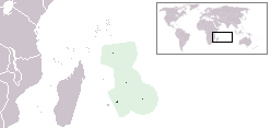
Location map for the Mauritius.
Originally created for English Wikipedia by Vardion.
| |
תמונה זו שוחררה לרשות הציבור על ידי היוצר שלה, Vardion במיזם Wikimedia Commons. זה תקף בכל העולם. במקרה ששחרור לרשות הציבור לא אפשרי מבחינה חוקית: |
היסטוריית הקובץ
ניתן ללחוץ על תאריך/שעה כדי לראות את הקובץ כפי שנראה באותו זמן.
| תאריך/שעה | תמונה ממוזערת | ממדים | משתמש | הערה | |
|---|---|---|---|---|---|
| נוכחית | 01:28, 16 בינואר 2012 | | 117 × 248 (3 ק"ב) | Ras67 (שיחה | תרומות) | cropped |
| 14:02, 1 ביוני 2008 |  | 119 × 250 (5 ק"ב) | Panos84 (שיחה | תרומות) | {{Information= Location of the island nation of Mauritius and its exclusive economic zone. |Source= Own work |Date= 01 June 2008 |Author= Panos84 (Panagiotis V. Lazaridis) }} | |
| 02:55, 5 במרץ 2008 |  | 119 × 250 (5 ק"ב) | Panos84 (שיחה | תרומות) | Location of the island nation of Mauritius and its exclusive economic zone. | |
| 18:32, 12 בדצמבר 2004 |  | 115 × 250 (5 ק"ב) | EugeneZelenko (שיחה | תרומות) | Location map for the Mauritius.<br/>Originally created for English Wikipedia by Vardion.<br/>{{PD}}<br/>Category:Country locator maps |
אין באפשרותך לדרוס את הקובץ הזה.
שימוש בקובץ
הדפים הבאים משתמשים בקובץ הזה:
- Atlas of Mauritius
- Locator maps of countries of Africa
- Maps of Mauritius
- Top 200 locator map images that should use vector graphics
- User:Ramiy/Location Maps
- User:Rei-artur/by/Mapas de localização de Países)
- File:British Indian Ocean Territory in its region (small islands magnified).svg
- File:DodoRangeMauritius.gif
- File:French Southern and Antarctic Lands in its region (Scattered islands in the Indian Ocean only) (small islands magnified).svg
- File:French Southern and Antarctic Lands wo Antarctica in its region (small islands magnified).svg
- File:Mauritius in its region (small islands magnified).svg
- File:Seychelles in its region (small islands magnified).svg
- Category:Female handball players from Mauritius
- Category:Female sportspeople from Mauritius
- Category:Women's beach handball players from Mauritius
.svg)
_(small_islands_magnified).svg)
.svg)
.svg)
.svg)
שימוש גלובלי בקובץ
אתרי הוויקי השונים הבאים משתמשים בקובץ זה:
- שימוש באתר als.wikipedia.org
- שימוש באתר am.wikipedia.org
- שימוש באתר ar.wikipedia.org
- שימוש באתר arz.wikipedia.org
- שימוש באתר ban.wikipedia.org
- שימוש באתר be-tarask.wikipedia.org
- שימוש באתר be.wikipedia.org
- שימוש באתר bg.wikipedia.org
- שימוש באתר bjn.wikipedia.org
- שימוש באתר bo.wikipedia.org
- שימוש באתר bpy.wikipedia.org
- שימוש באתר bs.wikipedia.org
- שימוש באתר ca.wikipedia.org
- שימוש באתר cv.wikipedia.org
- שימוש באתר da.wikipedia.org
- שימוש באתר de.wiktionary.org
- שימוש באתר en.wikipedia.org
- User:DanielZM/test
- User:Chris huh/List of African countries
- Portal:Africa/Countries/Selected country
- Portal:Africa/Countries/Selected country/33
- Outline of Mauritius
- List of Mauritius-related topics
- Category:Roman Catholic dioceses in Mauritius
- Wikipedia:Graphics Lab/Map workshop/Archive/Nov 2009
- Wikipedia:Graphics Lab/Map workshop/Archive/Jan 2010
- List of non-marine molluscs of Mauritius
- List of moths of Mauritius
- List of butterflies of Mauritius
- שימוש באתר en.wikinews.org
- שימוש באתר en.wiktionary.org
- שימוש באתר eo.wikipedia.org
- שימוש באתר eo.wiktionary.org
- שימוש באתר es.wikipedia.org
- שימוש באתר es.wikinews.org
- שימוש באתר et.wiktionary.org
- שימוש באתר ext.wikipedia.org
- שימוש באתר fa.wikipedia.org
- שימוש באתר fiu-vro.wikipedia.org
צפייה בשימושים גלובליים נוספים של קובץ זה.