File:Map Cleomenean War-en.svg
מתוך Wikimedia Commons
קפיצה לניווט
קפיצה לחיפוש

גודל התצוגה המקדימה הזאת מסוג PNG של קובץ ה־SVG הזה: 431 × 542 פיקסלים. רזולוציות אחרות: 191 × 240 פיקסלים | 382 × 480 פיקסלים | 611 × 768 פיקסלים | 814 × 1,024 פיקסלים | 1,628 × 2,048 פיקסלים.
לקובץ המקורי (קובץ SVG, הגודל המקורי: 431 × 542 פיקסלים, גודל הקובץ: 982 ק"ב)
מידע על הקובץ
נתונים מובְנים
כיתובים
כיתובים
נא להוסיף משפט שמסביר מה הקובץ מייצג
תוכן עניינים
תקציר[עריכה]
| תיאורMap Cleomenean War-en.svg |
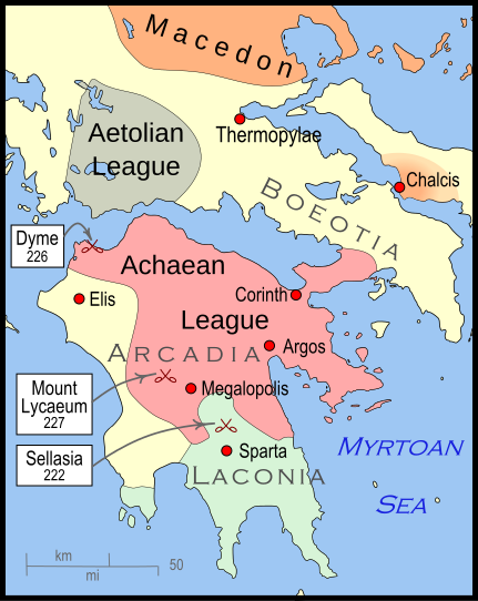
English: Mainland Greece during the time of the Cleomenean War, ca. 228 BCE |
| תאריך יצירה | |
| מקור | נוצר על־ידי מעלה היצירה |
| יוצר | MapMaster |
| גרסאות אחרות |
[עריכה]
|
References[עריכה]
The map itself was built using File:Greece map blank.svg, adding the now-drained Lake Copais. Towns were placed using geographic coordinates.
The borders of the various political entities were taken from several sources:
- Chamoux, François (2002) Hellenistic civilization, Wiley-Blackwell, ISBN 9780631222422, p. 206, for the Achaean League. I did not use this for the Aetolian League, since this map shows the later and larger borders of the Aetolian League, after the Cleomenean War.
- Gabbert, Janice J. (1997) Antigonus II Gonatas: a political biography, Routledge, ISBN 9780415018999 , p. 33, for the area under the control of Macedon.
- Shepherd, William (1911) "The Growth of Roman Power in Asia Minor", Historical Atlas, Henry Holt and Company. p. 33, was used as the primary reference for the Aetolian League.
- Shepherd, William (1911) "Greece under Theban Headship", Historical Atlas, Henry Holt and Company. p. 17, was used as the primary reference for the Spartan borders. When there was a conflict with the Chamoux map, I used the Chamoux map.
Any additional information on borders and areas under control would be very welcome.
Similar maps[עריכה]

רישיון[עריכה]
אני, בעל זכויות היוצרים על עבודה זו, מפרסם בזאת את העבודה תחת הרישיון הבא:
הקובץ הזה מתפרסם לפי תנאי רישיון קריאייטיב קומונז ייחוס-שיתוף זהה 3.0 לא מותאם.
- הנכם רשאים:
- לשתף – להעתיק, להפיץ ולהעביר את העבודה
- לערבב בין עבודות – להתאים את העבודה
- תחת התנאים הבאים:
- ייחוס – יש לתת ייחוס הולם, לתת קישור לרישיון, ולציין אם נעשו שינויים. אפשר לעשות את זה בכל צורה סבירה, אבל לא בשום צורה שמשתמע ממנה שמעניק הרישיון תומך בך או בשימוש שלך.
- שיתוף זהה – אם תיצרו רמיקס, תשנו, או תבנו על החומר, חובה עליכם להפיץ את התרומות שלך לפי תנאי רישיון זהה או תואם למקור.
היסטוריית הקובץ
ניתן ללחוץ על תאריך/שעה כדי לראות את הקובץ כפי שנראה באותו זמן.
| תאריך/שעה | תמונה ממוזערת | ממדים | משתמש | הערה | |
|---|---|---|---|---|---|
| נוכחית | 04:57, 12 בינואר 2010 |  | 542 × 431 (982 ק"ב) | MapMaster (שיחה | תרומות) | {{Information |Description={{en|1=A map of Greece during the Cleomenean War}} |Source={{own}} |Author=MapMaster |Date=11 January 2010 |Permission= |other_versions= }} Category:Maps of the history of Greece |
אין באפשרותך לדרוס את הקובץ הזה.
שימוש בקובץ
הדפים הבאים משתמשים בקובץ הזה:
- File:Cleomenean War Overview.svg (הפניה של קובץ)
- File:Cleomenes War detail 1.svg
- File:Map Cleomenean War-en.svg
- File:Map Cleomenean War-es.svg
- File:Map Cleomenean War-fr.svg
- File:Map Cleomenean War-he.svg
- File:Map Cleomenean War-hu.svg
- File:Map Cleomenean War-it.svg
- File:Map Cleomenean War-pt.svg
- File:Map Cleomenean War-zh.svg
- File:Map Cleomenean War (geo)-pt.svg
- Template:Other versions/Map Cleomenean War
- Category:Cleomenean War
שימוש גלובלי בקובץ
אתרי הוויקי השונים הבאים משתמשים בקובץ זה:
- שימוש באתר ar.wikipedia.org
- שימוש באתר bg.wikipedia.org
- שימוש באתר ca.wikipedia.org
- שימוש באתר el.wikipedia.org
- שימוש באתר en.wikipedia.org
- שימוש באתר et.wikipedia.org
- שימוש באתר he.wikipedia.org
- שימוש באתר it.wikipedia.org
- שימוש באתר ja.wikipedia.org
- שימוש באתר ko.wikipedia.org
- שימוש באתר nl.wikipedia.org
- שימוש באתר sh.wikipedia.org
- שימוש באתר tr.wikipedia.org
- שימוש באתר uk.wikipedia.org
- שימוש באתר vi.wikipedia.org
- שימוש באתר www.wikidata.org
- שימוש באתר zh.wikipedia.org


