File:Map Dutch World scris.png
Jump to navigation
Jump to search
ഈ പ്രിവ്യൂവിന്റെ വലിപ്പം: 800 × 351 പിക്സലുകൾ. മറ്റ് റെസലൂഷനുകൾ: 320 × 140 പിക്സലുകൾ | 640 × 281 പിക്സലുകൾ | 1,425 × 625 പിക്സലുകൾ.
പൂർണ്ണ വലിപ്പം (1,425 × 625 പിക്സൽ, പ്രമാണത്തിന്റെ വലിപ്പം: 61 കെ.ബി., മൈം തരം: image/png)
തലവാചകം
തലവാചകങ്ങൾ
ഈ പ്രമാണം എന്തിനെ പ്രതിനിധീകരിക്കുന്നുവെന്ന ഒറ്റവരി വിശദീകരണം ചേർക്കുക
ചുരുക്കം[തിരുത്തുക]
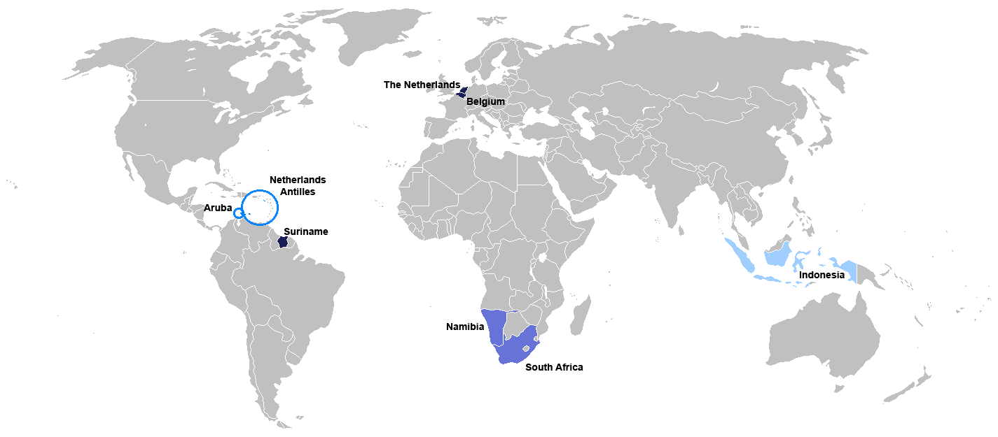
New map for Dutch-speaking world with country names. Modified version of Image:Map Dutch World nou.png
Deutsch: Legende:
- Dunkelblau: Mutter- und Mehrheitssprache
- Blau: Afrikaans (Tochtersprache)
- Hellblau: Zweit- oder nicht offizielle Sprache bzw. weiterhin vorhandene Kenntnis
English: English: Legend:
- Dark blue: native and majority language
- Blue: Afrikaans (daughter language)
- Light blue: secondary (non-official language), where some knowledge persists
Français : Français : Légende:
- Bleu foncé : langue maternelle et majoritaire
- Bleu : Afrikaans («langue fille»)
- Bleu clair : langue secondaire ou non officielle
Italiano: Italiano: Legenda:
- Blu scuro: lingua madre e maggioritaria
- Blu: Afrikaans (lingua affiliata)
- Blu chiaro: seconda lingua e/o non ufficiale, dove la sua conoscenza persiste sino ad oggi
Nederlands: Nederlands: Legenda:
- Donkerblauw: Moedertaal en belangrijkste taal
- Blauw: Afrikaans (dochtertaal)
- Lichtblauw: secundaire taal (niet-officiële taal), waar enkele kennis bestaat
Português: Português: Legenda:
- Azul escuro: língua mãe e majoritária
- Azul: Africâner (língua descendente)
- Azul claro: língua secundária (não oficial), onde ainda persiste algum conhecimento
Română: Română: Legendă:
- Albastru închis: limbă naţională
- Albastru: Afrikaans
- Albastru deschis: limbă secundară, neoficială
Español: Español : Leyenda:
- Azul obscuro : lengua materna y mayoritaria
- Azul : Afrikaans (lengua «hija»)
- Azul claro : lengua secundaria (no oficial), donde aún persiste conocimiento de ella.

|
ഈ പ്രമാണത്തേക്കാളും മെച്ചമായ File:Map of the Dutch World.svg എന്ന പ്രമാണം ഉള്ളതിനാൽ അതുപയോഗിക്കാൻ താത്പര്യപ്പെടുന്നു. ഉല്ലംഘിത പ്രമാണങ്ങൾ മായ്ക്കാൻ ഉഭയകക്ഷി സമ്മതം ആവശ്യമുണ്ടെന്ന് ദയവായി ശ്രദ്ധിക്കുക.
|

|
ഈ ചിത്രത്തിന്റെ ഒരു വെക്റ്റർ പതിപ്പ് (SVG) File:Map of the Dutch World.svg ലഭ്യമാണ്.
ഈ ചിത്രത്തിനേക്കാൾ മികച്ച റസല്യൂഷൻ ആവശ്യമെങ്കിൽ ഈ റാസ്റ്റർ ചിത്രത്തിനു പകരം അതുപയോഗിക്കേണ്ടതാണ്. File:Map Dutch World scris.png → File:Map of the Dutch World.svg
വെക്റ്റർ ഗ്രാഫിക്സിനെക്കുറിച്ച് കൂടുതൽ അറിയണമെന്നുണ്ടെങ്കിൽ, എസ്.വി.ജി.യിലേയ്ക്കുള്ള മാറ്റം എന്ന താൾ കാണുക. മീഡിയവിക്കിയിൽ എസ്.വി.ജി.യ്ക്കുള്ള പിന്തുണ എന്നുമൊരു താൾ നിലവിലുണ്ട്. |
 |
അനുമതി[തിരുത്തുക]
ഈ സൃഷ്ടിയുടെ പകർപ്പവകാശ ഉടമയായ ഞാൻ, താഴെ പറയുന്ന അനുമതിയിൽ ഈ സൃഷ്ടി ഇതിനാൽ പ്രസിദ്ധീകരിക്കുന്നു:

|
സ്വതന്ത്ര സോഫ്റ്റ്വേർ സമിതി പ്രസിദ്ധീകരിച്ചിട്ടുള്ള ഗ്നു സ്വതന്ത്ര പ്രമാണ അനുവാദപത്രം പതിപ്പ് 1.2 അല്ലെങ്കിൽ പുതിയ പതിപ്പുകൾ പ്രകാരം; മാറ്റമില്ലാത്ത ഭാഗങ്ങളില്ലാതെ, മുൻചട്ടയിലെ എഴുത്തുകൾ ഇല്ലാതെ, പിൻചട്ടയിലെ എഴുത്തുകൾ ഇല്ലാതെ പകർത്താനും, വിതരണം ചെയ്യാനും ഒപ്പം/അല്ലെങ്കിൽ ഈ പ്രമാണത്തിൽ മാറ്റം വരുത്തുവാനും ഉള്ള അവകാശങ്ങൾ നൽകുന്നു. ഗ്നു സ്വതന്ത്ര പ്രമാണ അനുവാദപത്രം എന്ന തലക്കെട്ടിൽ അനുവാദപത്രത്തിന്റെ ഒരു പകർപ്പ് ഉൾപ്പെടുത്തിയിട്ടുണ്ട്. |
| ഈ പ്രമാണത്തിന് അനുമതി നൽകപ്പെട്ടിരിക്കുന്നത് ക്രിയേറ്റീവ് കോമൺസ് ആട്രിബ്യൂഷൻ-ഷെയർ എലൈക് 3.0 അൺപോർട്ടഡ് അനുവാദപത്ര പ്രകാരമാണ്. | ||
| ||
| ജി.എഫ്.ഡി.എൽ. അനുവാദപത്രത്തിന്റെ അനുമതി പുതുക്കലിന്റെ ഭാഗമായാണ് ഈ ടാഗ് ചേർക്കപ്പെട്ടിരിക്കുന്നത്. |
പ്രമാണ നാൾവഴി
ഏതെങ്കിലും തീയതി/സമയ കണ്ണിയിൽ ഞെക്കിയാൽ പ്രസ്തുതസമയത്ത് ഈ പ്രമാണം എങ്ങനെയായിരുന്നു എന്നു കാണാം.
| തീയതി/സമയം | ലഘുചിത്രം | അളവുകൾ | ഉപയോക്താവ് | അഭിപ്രായം | |
|---|---|---|---|---|---|
| നിലവിലുള്ളത് | 19:06, 7 ജൂലൈ 2010 | | 1,425 × 625 (61 കെ.ബി.) | Hooiwind (സംവാദം | സംഭാവനകൾ) | deeper colours so it is easier to see the countries on a smaller scale + removal of "minority dots", geographically confusing and pretty arbitrary. |
| 17:46, 16 ഫെബ്രുവരി 2007 |  | 1,425 × 625 (34 കെ.ബി.) | Danutz (സംവാദം | സംഭാവനകൾ) | New map for Dutch-speaking world with country names. Modified version of Image:Map Dutch World nou.png English: Legend: *Dark blue: native language *Blue: administrative language *Light blue: secondary, non-official language *Green square: minori |
ഈ പ്രമാണത്തിനു മുകളിൽ മറ്റൊരു പ്രമാണം ചേർക്കാൻ താങ്കൾക്ക് കഴിയില്ല.
പ്രമാണത്തിന്റെ ഉപയോഗം
താഴെ കാണുന്ന 2 താളുകളിൽ ഈ ചിത്രം ഉപയോഗിക്കുന്നു:
പ്രമാണത്തിന്റെ ആഗോള ഉപയോഗം
താഴെ കൊടുത്തിരിക്കുന്ന മറ്റ് വിക്കികൾ ഈ പ്രമാണം ഉപയോഗിക്കുന്നു:
- jv.wikipedia.org സംരംഭത്തിലെ ഉപയോഗം
- nl.wikibooks.org സംരംഭത്തിലെ ഉപയോഗം
- sat.wikipedia.org സംരംഭത്തിലെ ഉപയോഗം