File:Map of Ohio NA.png
קפיצה לניווט
קפיצה לחיפוש

גודל התצוגה המקדימה הזאת: 800 × 542 פיקסלים. רזולוציות אחרות: 320 × 217 פיקסלים | 640 × 434 פיקסלים | 1,024 × 694 פיקסלים | 1,280 × 867 פיקסלים | 1,967 × 1,333 פיקסלים.
לקובץ המקורי (1,967 × 1,333 פיקסלים, גודל הקובץ: 2.02 מ"ב, סוג MIME: image/png)
כיתובים
כיתובים
נא להוסיף משפט שמסביר מה הקובץ מייצג
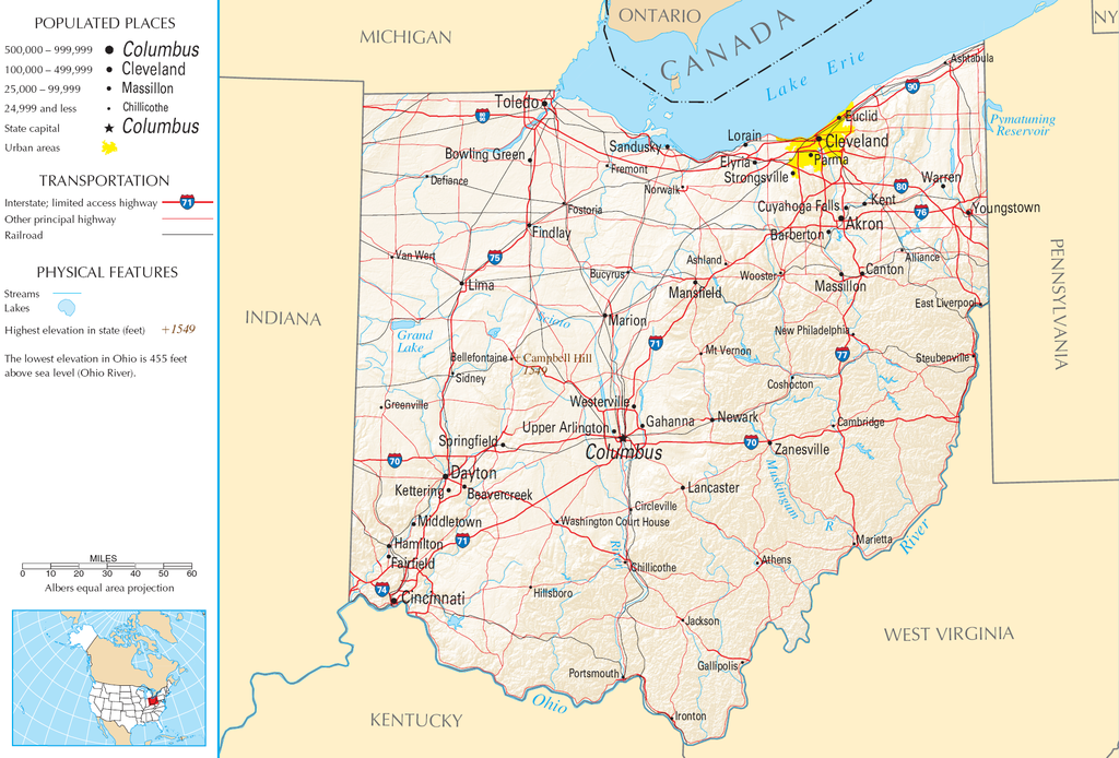
| תיאור | Map of Ohio |
| מקור | National Atlas |
| יוצר |
This map was obtained from an edition of the National Atlas of the United States. Like almost all works of the U.S. federal government, works from the National Atlas are in the public domain in the United States.
Online access: NationalAtlas.gov | 1970 print edition: Library of Congress, Perry-Castañeda Library
|
היסטוריית הקובץ
ניתן ללחוץ על תאריך/שעה כדי לראות את הקובץ כפי שנראה באותו זמן.
| תאריך/שעה | תמונה ממוזערת | ממדים | משתמש | הערה | |
|---|---|---|---|---|---|
| נוכחית | 11:21, 30 באוגוסט 2007 | | 1,333 × 1,967 (2.02 מ"ב) | Conscious (שיחה | תרומות) | cropped |
| 08:02, 15 באוגוסט 2006 |  | 1,640 × 2,122 (2.17 מ"ב) | Huebi~commonswiki (שיחה | תרומות) | {{Information| |Description=Map of Ohio |Source=[http://www.nationalatlas.gov National Atlas] }} Category:Maps of the United States Category:Maps of Ohio {{PD-USGov-Atlas}} |
אין באפשרותך לדרוס את הקובץ הזה.
שימוש בקובץ
אין דפים המשתמשים בקובץ זה.
שימוש גלובלי בקובץ
אתרי הוויקי השונים הבאים משתמשים בקובץ זה:
- שימוש באתר arz.wikipedia.org
- שימוש באתר de.wikipedia.org
- שימוש באתר en.wikipedia.org
- שימוש באתר es.wikipedia.org
- שימוש באתר eu.wikipedia.org
- שימוש באתר fr.wikipedia.org
- שימוש באתר gl.wikipedia.org
- שימוש באתר hr.wiktionary.org
- שימוש באתר hsb.wikipedia.org
- שימוש באתר hu.wikipedia.org
- שימוש באתר incubator.wikimedia.org
- שימוש באתר io.wikipedia.org
- שימוש באתר it.wikipedia.org
- שימוש באתר ja.wikipedia.org
- שימוש באתר kk.wikipedia.org
- שימוש באתר mk.wikipedia.org
- שימוש באתר mr.wikipedia.org
- שימוש באתר nl.wikipedia.org
- שימוש באתר rue.wikipedia.org
- שימוש באתר ru.wikipedia.org
- שימוש באתר stq.wikipedia.org
- שימוש באתר sw.wikipedia.org
- שימוש באתר szl.wikipedia.org
- שימוש באתר zea.wikipedia.org