File:Map of Shootings at Kent State University in 1970.jpg
קפיצה לניווט
קפיצה לחיפוש
גודל התצוגה המקדימה הזאת: 770 × 600 פיקסלים. רזולוציות אחרות: 308 × 240 פיקסלים | 616 × 480 פיקסלים | 986 × 768 פיקסלים | 1,200 × 935 פיקסלים.
לקובץ המקורי (1,200 × 935 פיקסלים, גודל הקובץ: 364 ק"ב, סוג MIME: image/jpeg)
כיתובים
כיתובים
נא להוסיף משפט שמסביר מה הקובץ מייצג
תקציר[עריכה]
| תיאור |
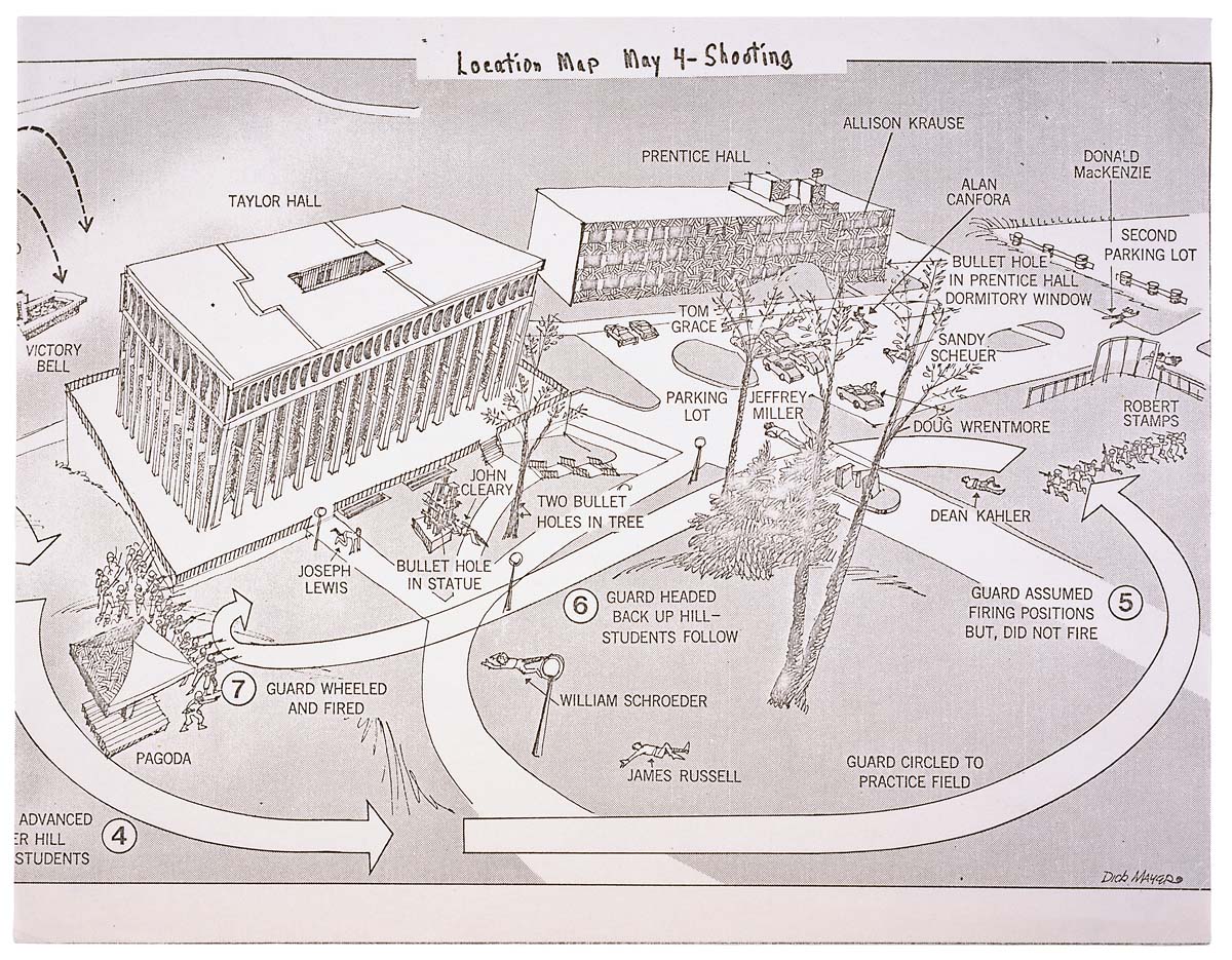
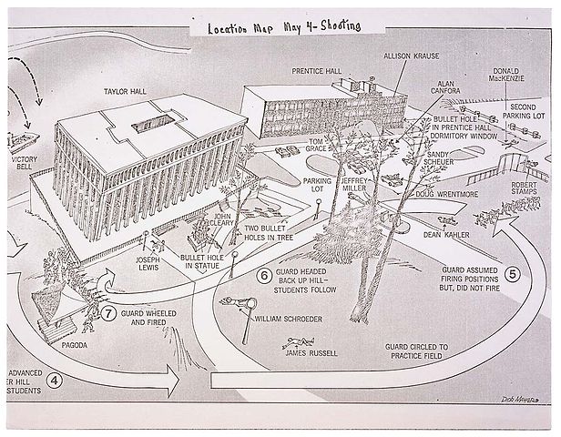
English: This is a printed map detailing the locations of structures, troop movements, bullet hole locations, and locations of casualties at the Kent State shooting of May 4, 1970. |
|||
| תאריך יצירה | 5/04/1970 | |||
| מקור | https://catalog.archives.gov/id/596837 | |||
| יוצר | President (1969-1974 : Nixon). President's Commission on Campus Unrest. | |||
| אישורים והיתרים (שימוש חוזר בקובץ זה) |
|
רישיון[עריכה]
This work is in the public domain in the United States because it is a work prepared by an officer or employee of the United States Government as part of that person’s official duties under the terms of Title 17, Chapter 1, Section 105 of the US Code.
Note: This only applies to original works of the Federal Government and not to the work of any individual U.S. state, territory, commonwealth, county, municipality, or any other subdivision. This template also does not apply to postage stamp designs published by the United States Postal Service since 1978. (See § 313.6(C)(1) of Compendium of U.S. Copyright Office Practices). It also does not apply to certain US coins; see The US Mint Terms of Use.
|
 | |
| הקובץ הזה זוהה כקובץ חופשי מכל מגבלה ידועה תחת חוק זכויות היוצרים, כולל כל הזכויות הקשורות והסמוכות. | ||
היסטוריית הקובץ
ניתן ללחוץ על תאריך/שעה כדי לראות את הקובץ כפי שנראה באותו זמן.
| תאריך/שעה | תמונה ממוזערת | ממדים | משתמש | הערה | |
|---|---|---|---|---|---|
| נוכחית | 01:26, 9 ביוני 2008 | | 935 × 1,200 (364 ק"ב) | Goldfishbutt (שיחה | תרומות) | {{Information |Description={{en|1=This is a printed map detailing the locations of structures, troop movements, bullet hole locations, and locations of casualties at the Kent State shooting of May 4, 1970.}} |Source=http://arcweb.archives.gov/arc/arch_res |
אין באפשרותך לדרוס את הקובץ הזה.
שימוש בקובץ
אין דפים המשתמשים בקובץ זה.
שימוש גלובלי בקובץ
אתרי הוויקי השונים הבאים משתמשים בקובץ זה:
- שימוש באתר af.wikipedia.org
- שימוש באתר de.wikipedia.org
- שימוש באתר en.wikipedia.org
- שימוש באתר en.wikibooks.org
- שימוש באתר en.wikiquote.org
- שימוש באתר fr.wikipedia.org
- שימוש באתר he.wikipedia.org
- שימוש באתר it.wikipedia.org
- שימוש באתר ja.wikipedia.org
- שימוש באתר nl.wikipedia.org
- שימוש באתר no.wikipedia.org
- שימוש באתר sv.wikipedia.org
- שימוש באתר zh.wikipedia.org