File:Map of traditional provinces of Libye-en.svg
קפיצה לניווט
קפיצה לחיפוש

גודל התצוגה המקדימה הזאת מסוג PNG של קובץ ה־SVG הזה: 625 × 599 פיקסלים. רזולוציות אחרות: 250 × 240 פיקסלים | 501 × 480 פיקסלים | 801 × 768 פיקסלים | 1,068 × 1,024 פיקסלים | 2,136 × 2,048 פיקסלים | 969 × 929 פיקסלים.
לקובץ המקורי (קובץ SVG, הגודל המקורי: 969 × 929 פיקסלים, גודל הקובץ: 106 ק"ב)
כיתובים
כיתובים
נא להוסיף משפט שמסביר מה הקובץ מייצג
| תיאור |
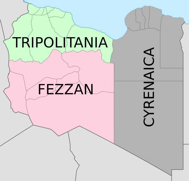
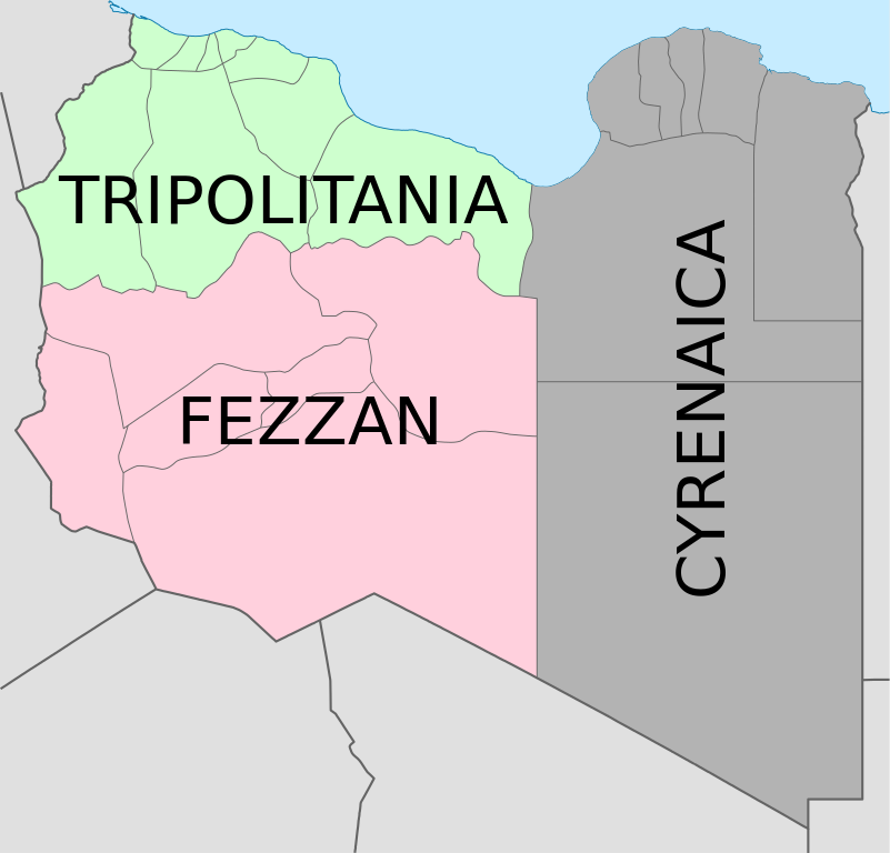
Deutsch: Historische provinzen (Governorates) Libyens English: Map of the three Governorates of Libya based on the borders of today's governorates. After independence in 1951, until 1963, Libya was divided into three governorates (muhafazat): Cyrenaica, Tripolitania, and Fezzan. The eastern border between Tripolitania and Fezzan was before 1969 slightly different: the northern part of Al Jufrah District in today's Fezzan belonged to Tripolitania, see here File:Ottoman Provinces Of Present day Libyapng.png. Español: Mapa de las tres governorates de Libia: Tripolitania, Fezzan, y Cirenaica. Français : Carte en anglais des trois provinces historiques (gouvernorats) de la Libye contemporaine. |
| תאריך יצירה | (UTC) |
| מקור | |
| יוצר |
|
| גרסאות אחרות |
|


| זוהי תמונה מרוטשת, זאת אומרת שהתמונה שונתה בצורה דיגיטלית מהמקור. Modifications: translation in english. את התמונה המקורית ניתן לראות ב: Map of traditionnal provinces of Libye fr.svg. השינוי בוצע על ידי Bourrichon.
|
אני, בעל זכויות היוצרים על היצירה הזאת, מפרסם אותה בזאת תחת הרישיונות הבאים:
הקובץ הזה מתפרסם לפי תנאי רישיון קריאייטיב קומונז ייחוס 3.0 לא מותאם.
- הנכם רשאים:
- לשתף – להעתיק, להפיץ ולהעביר את העבודה
- לערבב בין עבודות – להתאים את העבודה
- תחת התנאים הבאים:
- ייחוס – יש לתת ייחוס הולם, לתת קישור לרישיון, ולציין אם נעשו שינויים. אפשר לעשות את זה בכל צורה סבירה, אבל לא בשום צורה שמשתמע ממנה שמעניק הרישיון תומך בך או בשימוש שלך.

|
מוענקת בכך הרשות להעתיק, להפיץ או לשנות את המסמך הזה, לפי תנאי הרישיון לשימוש חופשי במסמכים של גנו, גרסה 1.2 או כל גרסה מאוחרת יותר שתפורסם על־ידי המוסד לתוכנה חופשית; ללא פרקים קבועים, ללא טקסט עטיפה קדמית וללא טקסט עטיפה אחורית. עותק של הרישיון כלול בפרק שכותרתו הרישיון לשימוש חופשי במסמכים של גנו. |
הנכם מוזמנים לבחור את הרישיון הרצוי בעיניכם.
יומן העלאה מקורי
[עריכה]
This image is a derivative work of the following images:
- File:Map_of_traditionnal_provinces_of_Libye_fr.svg licensed with Cc-by-3.0, GFDL
- 2011-02-25T14:34:29Z Пакко 969x929 (120204 Bytes) upg
- 2011-02-25T13:46:48Z Xfigpower 970x931 (162661 Bytes) {{Information |Description={{fr|les trois provinces mappées sur la arte actuelle de la LibyeLes couleurs sont celles symbolisées par le drapeau}} |Source=*[[:File:Libya_location_map.svg|]] |Date=2011-02-25 13:29 (UTC) |Auth
Uploaded with derivativeFX
היסטוריית הקובץ
ניתן ללחוץ על תאריך/שעה כדי לראות את הקובץ כפי שנראה באותו זמן.
| תאריך/שעה | תמונה ממוזערת | ממדים | משתמש | הערה | |
|---|---|---|---|---|---|
| נוכחית | 08:36, 24 באוגוסט 2021 | | 929 × 969 (106 ק"ב) | أحمد الغرباوي (שיחה | תרומות) | File uploaded using svgtranslate tool (https://svgtranslate.toolforge.org/). Added translation for ar. |
| 15:44, 6 בדצמבר 2020 |  | 929 × 969 (104 ק"ב) | ידידיה צ' צבאן (שיחה | תרומות) | File uploaded using svgtranslate tool (https://svgtranslate.toolforge.org/). Added translation for he. | |
| 03:46, 12 באוקטובר 2011 |  | 929 × 969 (104 ק"ב) | Spesh531 (שיחה | תרומות) | updated to current internal boundaries | |
| 12:50, 30 באוגוסט 2011 |  | 929 × 969 (147 ק"ב) | Orange Tuesday (שיחה | תרומות) | see http://www.crwflags.com/fotw/flags/ly_1951.html for source on traditional colours | |
| 01:40, 30 באוגוסט 2011 |  | 929 × 969 (124 ק"ב) | Hellerick (שיחה | תרומות) | Found no information on "traditional association" | |
| 20:24, 13 ביוני 2011 |  | 929 × 969 (147 ק"ב) | Kmusser (שיחה | תרומות) | shift colors to match traditional association | |
| 11:04, 29 באפריל 2011 |  | 929 × 969 (125 ק"ב) | Hellerick (שיחה | תרומות) | Neutral colors; + foreign nations borders | |
| 13:02, 16 במרץ 2011 |  | 929 × 969 (121 ק"ב) | Bourrichon (שיחה | תרומות) | typo | |
| 13:01, 16 במרץ 2011 |  | 929 × 969 (121 ק"ב) | Bourrichon (שיחה | תרומות) | +bug typo | |
| 12:58, 16 במרץ 2011 |  | 929 × 969 (112 ק"ב) | Bourrichon (שיחה | תרומות) | {{Information |Description={{de|Historische provinzen (Governorates) Libyens}} {{en| Map of the three '''{{w|Governorates of Libya}}'''. After independence in 1951, until 1963, Libya was divided into three governorates (''{{w|muhafazat}}''): '''{{w|Cyrena |
אין באפשרותך לדרוס את הקובץ הזה.
שימוש בקובץ
הדפים הבאים משתמשים בקובץ הזה:
- File:Map of traditional provinces of Libye-ar.png
- File:Map of traditional provinces of Libye-ar.svg
- File:Map of traditional provinces of Libye-ka.png
- File:Map of traditional provinces of Libye-no.svg
- File:Map of traditional provinces of Libye-pt.svg
- File:Map of traditionnal provinces of Libye-en.svg (הפניה של קובץ)
- File:Ottoman Provinces Of Present day Libya.png
- Category:Cyrenaica
- Category:Postage stamps of Cyrenaica
- Category:Stamps of Italian Libya
שימוש גלובלי בקובץ
אתרי הוויקי השונים הבאים משתמשים בקובץ זה:
- שימוש באתר ar.wikipedia.org
- שימוש באתר ast.wikipedia.org
- שימוש באתר az.wikipedia.org
- שימוש באתר bs.wikipedia.org
- שימוש באתר ca.wikipedia.org
- שימוש באתר cs.wikipedia.org
- שימוש באתר diq.wikipedia.org
- שימוש באתר en.wikipedia.org
- History of Libya
- Libya
- Geography of Libya
- Demographics of Libya
- Politics of Libya
- Economy of Libya
- Mass media in Libya
- Transport in Libya
- Armed Forces of the Libyan Arab Jamahiriya
- Foreign relations of Libya under Muammar Gaddafi
- Fatimid Caliphate
- Idris of Libya
- List of cities in Libya
- Operation Sonnenblume
- Libyan dinar
- List of heads of state of Libya
- Districts of Libya
- Great Man-Made River
- List of colonial governors of Italian Cyrenaica
- List of heads of government of Libya
- Music of Libya
- Elections in Libya
- Karamanli dynasty
- Ahmed Karamanli
- Culture of Libya
- Central Bank of Libya
- Public Scout and Girl Guide Movement
- General People's Congress (Libya)
- Human rights in Libya
- Subdivisions of Libya
- Provinces of Libya
- Islamic Tripolitania and Cyrenaica
- Ottoman Tripolitania
- Italian colonization of Libya
- History of Libya under Muammar Gaddafi
- Chadian–Libyan War
- Ancient Libya
- Template:Libya topics
- Media of Libya
צפייה בשימושים גלובליים נוספים של קובץ זה.