-
Map of Kievan Rus in Spanish
-
Map of Kievan Rus in Russian
-
Map of Russian regions belonging to Siberia
-
Subdivisions of the Tsardom of Russia in 1708
-
Subdivisions of the Russian Empire in 1914
-
Subdivisions of Mexico (in Russian)
-
Administrative subdivisions of Krasnoyarsk
-
Soviet Caucasus in 1957-1991
-
Ob-Yenisei Canal
-
Map of the regions of Russia with their postal codes
-
The Magic Roundabout (officially known as the Greenstead Roundabout) in Colchester
-
Map of the Extreme North territories (Russia)
-
Map of the Smaller Road of Life (WWII)
-
Siege of Leningrad, September 21, 1941
-
WWII: Two Lines War (1940)
-
The Metropolitan Green Belt among the green belts of England
-
"Coloring book" map of Ocenia
-
Tibet according to different claims
-
Arctic voyage of the submarine K-524
-
Map of the world in Soviet-like color-scheme
-
The Pennines
-
Philippines location map
-
Philippines location map
-
Central Russia
-
United Deep Waterway System of European Russia
-
Hernán Cortés' possessions in Mexico
-
Amelia Earhart flight route
-
Greek state alliances in 362 BCE
-
Blank map for the northern river reversal
-
Ice Age glacial lakes of Siberia and Central Asia
-
Constituent entities of the Federation of South Arabia
-
Yugoslavia under Axis occupation in 1941-1943
-
Location map of Transcaucasia
-
Location map of the Siberian Federal District (political)
-
Location map of the Siberian Federal District (physical)
-
Location map of the Urals Federal District (political)
-
Location map of the Urals Federal District (physical)
-
Location map of the North Caucasian Federal District (political)
-
Location map of the North Caucasian Federal District (physical)
-
Location map of the Southern Federal District (political)
-
Location map of the Southern Federal District (physical)
-
Soviet Union location map (1980s)
-
Soviet Union location map (1980s, no rivers)
-
Soviet Union location map (1937)
-
Soviet Union location map (1937, no rivers)
-
The world as of 1937
-
Blank topographic map of the British Isles
-
Blank political map of the Caucasus in 1903.
-
Maria Island, Tasmania.
-
Krasnoyarsk metro as planned in the 1990s
-
River Derwent at Hobart, Tasmania
-
The route of the ship Zarya, and the rescue party lead by Kolchak (1901-1902)
-
The Russian Polar Expedition of 1900-1902.
-
Crimean Federal District
-
Map of Aleksandr Kolchak's attempt to save Eduard von Toll.
-
Soviet Union location map (1980s, oblast-level division)
-
Soviet Union subdivisions by type
-
Map of Southern Russia
-
Old City of Jerusalem blank map
-
Map of the Roman Empire during the First Tetrarchy.
-
Physical location map of Eurasia.
-
Political location map of Eurasia.
-
Maya civilization
-
Yaxchilán
-
Derwent River basin (Tasmania)
-
Mayan trade routes
-
Lenné Triangle, Berlin during the Cold War
-
Steinstücken during the Cold War
-
Jersey Shore shark attacks (1916)
-
Russian Black Sea coast
-
Railways of Moscow Oblast
-
Railways of Moscow
-
West Ukrainian People's Republic
-
Provinces of Prussia in 1806
-
Groznenskaya Oblast in 1949
-
Solar Neighborhood
-
Greater Bashkiria in 1922
-
Counties of Pomerania in 1939
-
Mariana Trench location
-
North-South Transport Corridor
-
1917-1928 Soviet Ukraine borders formation
-
Administrative division of Central Chernozem Oblast in 1930
-
Zimnyaya Vishnya fire scheme
-
Smaller Bashkiria in 1919
-
Appellation court districts of Russia
-
Cassation court districts of Russia
-
Arbitration appeal court districts of Russia
-
National state delimitation of Central Asia (1924-1925)
-
North-Eastern Rus principalities (13th century)
-
North-Eastern Rus principalities (14th century)
-
Scheme of Sebastopolis Octogon
-
The seats in the State Duma of Russia in 2007
-
The seats in the State Duma of Russia in 2011
-
The seats in the State Duma of Russia in 2016
-
MICEX Index graph
-
RTSI graph
-
International reserve of the Russian Federation
-
Krasnoyarsk population graph
-
Egyptian license plate for tourist busses
-
The Amur River level during the flood of 2013.
-
Former Soviet standard for paper formats.
-
Neodymium glass transmission spectrum.
-
Diagram of true and visible horizon.
-
Struysky Earth curvature nomograph.
-
Natural landmark placeholder image.
-
Dohyo for sumo
-
Consonants of the Russian linguistic alphabet
-
Vowels of the Russian linguistic alphabet
-
Bosnian Cyrillic alphabet
-
Kazakh Latin alphabet table (2018)
-
Kazakh Latin alphabet table (2021)
-
Magomed Shatayev's signature
 Map of Kievan Rus in Spanish
 Map of Kievan Rus in Russian
 Map of Russian regions belonging to Siberia
 Subdivisions of the Tsardom of Russia in 1708
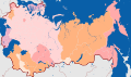 Subdivisions of the Russian Empire in 1914
 Subdivisions of Mexico (in Russian)
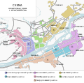 Administrative subdivisions of Krasnoyarsk
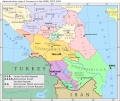 Soviet Caucasus in 1957-1991
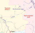 Ob-Yenisei Canal
 Map of the regions of Russia with their postal codes
 The Magic Roundabout (officially known as the Greenstead Roundabout) in Colchester
 Map of the Extreme North territories (Russia)
 Map of the Smaller Road of Life (WWII)
 Siege of Leningrad, September 21, 1941
 WWII: Two Lines War (1940)
 The Metropolitan Green Belt among the green belts of England
 "Coloring book" map of Ocenia
 Tibet according to different claims
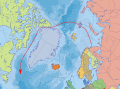 Arctic voyage of the submarine K-524
 Map of the world in Soviet-like color-scheme
 The Pennines
 Philippines location map
 Philippines location map
 Central Russia
 United Deep Waterway System of European Russia
 Hernán Cortés' possessions in Mexico
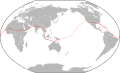 Amelia Earhart flight route
 Greek state alliances in 362 BCE
 Blank map for the northern river reversal
 Ice Age glacial lakes of Siberia and Central Asia
 Constituent entities of the Federation of South Arabia
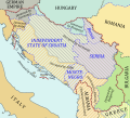 Yugoslavia under Axis occupation in 1941-1943
 Location map of Transcaucasia
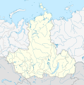 Location map of the Siberian Federal District (political)
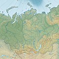 Location map of the Siberian Federal District (physical)
 Location map of the Urals Federal District (political)
 Location map of the Urals Federal District (physical)
 Location map of the North Caucasian Federal District (political)
 Location map of the North Caucasian Federal District (physical)
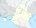 Location map of the Southern Federal District (political)
 Location map of the Southern Federal District (physical)
 Soviet Union location map (1980s)
 Soviet Union location map (1980s, no rivers)
 Soviet Union location map (1937)
 Soviet Union location map (1937, no rivers)
 The world as of 1937
 Blank topographic map of the British Isles
 Blank political map of the Caucasus in 1903.
 Maria Island, Tasmania.
 Krasnoyarsk metro as planned in the 1990s
 River Derwent at Hobart, Tasmania
 The route of the ship Zarya, and the rescue party lead by Kolchak (1901-1902)
 The Russian Polar Expedition of 1900-1902.
 Crimean Federal District
 Map of Aleksandr Kolchak's attempt to save Eduard von Toll.
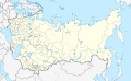 Soviet Union location map (1980s, oblast-level division)
 Soviet Union subdivisions by type
 Map of Southern Russia
 Old City of Jerusalem blank map
 Map of the Roman Empire during the First Tetrarchy.
 Physical location map of Eurasia.
 Political location map of Eurasia.
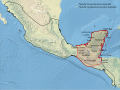 Maya civilization
 Yaxchilán
 Derwent River basin (Tasmania)
 Mayan trade routes
 Lenné Triangle, Berlin during the Cold War
 Steinstücken during the Cold War
 Jersey Shore shark attacks (1916)
 Russian Black Sea coast
 Railways of Moscow Oblast
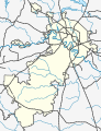 Railways of Moscow
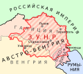 West Ukrainian People's Republic
 Provinces of Prussia in 1806
 Groznenskaya Oblast in 1949
 Solar Neighborhood
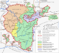 Greater Bashkiria in 1922
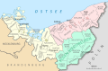 Counties of Pomerania in 1939
 Mariana Trench location
 North-South Transport Corridor
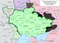 1917-1928 Soviet Ukraine borders formation
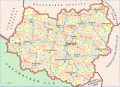 Administrative division of Central Chernozem Oblast in 1930
 Zimnyaya Vishnya fire scheme
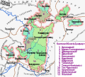 Smaller Bashkiria in 1919
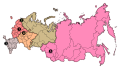 Appellation court districts of Russia
 Cassation court districts of Russia
 Arbitration appeal court districts of Russia
 National state delimitation of Central Asia (1924-1925)
 North-Eastern Rus principalities (13th century)
 North-Eastern Rus principalities (14th century)
 Scheme of Sebastopolis Octogon
.svg)

.svg)


.svg)


.svg)
.svg)


.svg)
.svg)
.svg)
.svg)


.svg)

.svg)


.svg)


.svg)


.svg)
.svg)

.svg)


.svg)


 Map of the world made in my own projection
 Another map projection invented by me
 A physical map in a version of this projection (1).
 A physical map in a version of this projection (2).
 Gauss Krueger map zones on globe
 Gauss Krueger map zones on flat surface
 Grid of World Map 1:2,500,000 sheets


 Krasnoyarskiy Kray
 Arkhangelskaya Oblast
 Divnogorsk
 Kemerovo
 Mari El
 Volgogradskaya Oblast
 Kurskaya Oblast
 Jewish Autonomous Oblast
 Kurganskaya Oblast
 Nenetskiy Autonomous Okrug
 Orlovskaya Oblast
 Igarka
 Yalta
Yalta Dyatlovichi
 Schärding
 Braunau am Inn
 Ried im Innkreis
 Divnogorsk (2020), hatched
 Divnogorsk (2020), without crown
 Divnogorsk (2020), crowned

_(vector).svg)


.svg)


 Soviet-time COA of Chelyabinsk
 Soviet-time COA of Divnogorgsk
 Soviet-time COA of Divnogorsk
 Soviet-time COA of Yeysk
 Soviet-time COA of Yeysk
 Prince Vladimir's seal
 Drug Enforcement Administration logo
 Russia 1 TV channel logo
 Russian military roundel
 Russian police roundel
 Benelux star
 East Slavic cube
 DR3 channel
 East Germany
 Turkistan Legion
 WikiProject Scouting Japan
 Cross of Novgorod
 Transnistrian ruble sign
 Rotor FC banner
 International Organization of Journalists


 Krasnoyarskiy Kray
 Volgogradskaya Oblast
 Krasnodarskiy Kray
 Permskaya Oblast
 Belgorodskaya Oblast
 Irkutskaya Oblast
 US UK flags blending
 Block of flags of Serbia, UK, Spain, and Russia
 My Australian flag proposal
 Río Negro Province (Argentina)
 Mari El
 Possible 52-star US flag
 Turkic Council
 Kurskaya Oblast
 City of Yalta (2005-2015)
 City of Yalta
 City of Vorkuta
 Solar eclipse flag for the Earth
 Friuli-Venezia Giulia
 Ilovlinskiy Rayon
 Lingua Franca Nova (2004)
 Lingua Franca Nova (2008)
 Radishchev
 Divnogorsk (2020)
 Great River flag of Mississippi


.svg)


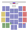 The seats in the State Duma of Russia in 2007
 The seats in the State Duma of Russia in 2011
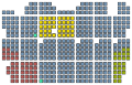 The seats in the State Duma of Russia in 2016
 MICEX Index graph
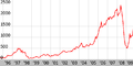 RTSI graph
 International reserve of the Russian Federation
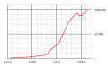 Krasnoyarsk population graph
 Egyptian license plate for tourist busses
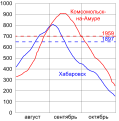 The Amur River level during the flood of 2013.
 Former Soviet standard for paper formats.
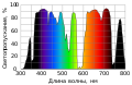 Neodymium glass transmission spectrum.
 Diagram of true and visible horizon.
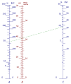 Struysky Earth curvature nomograph.
 Natural landmark placeholder image.
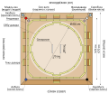 Dohyo for sumo
 Consonants of the Russian linguistic alphabet
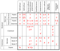 Vowels of the Russian linguistic alphabet
 Bosnian Cyrillic alphabet
 Kazakh Latin alphabet table (2018)
 Kazakh Latin alphabet table (2021)
 Magomed Shatayev's signature


.svg)


.svg)