File:Mediterraneo centrale 300 a.C. - epoca di Agatocle.png
Vai alla navigazione
Vai alla ricerca

Dimensioni di questa anteprima: 800 × 523 pixel. Altre risoluzioni: 320 × 209 pixel | 640 × 419 pixel | 1 024 × 670 pixel | 1 280 × 837 pixel | 1 639 × 1 072 pixel.
File originale (1 639 × 1 072 pixel, dimensione del file: 1,72 MB, tipo MIME: image/png)
Didascalie
Didascalie
Aggiungi una brevissima spiegazione di ciò che questo file rappresenta
Dettagli[modifica]
| Descrizione |
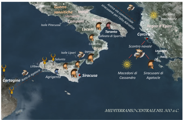
Italiano: Mediterraneo centrale 300 a.C. - epoca di Agatocle |
| Data | |
| Fonte | Opera propria |
| Autore | Stella |
Licenza[modifica]
Io, detentore del copyright su quest'opera, dichiaro di pubblicarla con la seguente licenza:
Questo file è disponibile in base alla licenza Creative Commons Attribuzione-Condividi allo stesso modo 4.0 Internazionale
- Tu sei libero:
- di condividere – di copiare, distribuire e trasmettere quest'opera
- di modificare – di adattare l'opera
- Alle seguenti condizioni:
- attribuzione – Devi fornire i crediti appropriati, un collegamento alla licenza e indicare se sono state apportate modifiche. Puoi farlo in qualsiasi modo ragionevole, ma non in alcun modo che suggerisca che il licenziante approvi te o il tuo uso.
- condividi allo stesso modo – Se remixi, trasformi o sviluppi il materiale, devi distribuire i tuoi contributi in base alla stessa licenza o compatibile all'originale.
Cronologia del file
Fare clic su un gruppo data/ora per vedere il file come si presentava nel momento indicato.
| Data/Ora | Miniatura | Dimensioni | Utente | Commento | |
|---|---|---|---|---|---|
| attuale | 14:36, 30 giu 2017 | | 1 639 × 1 072 (1,72 MB) | Stella (discussione | contributi) | User created page with UploadWizard |
Impossibile sovrascrivere questo file.
Utilizzo del file
Nessuna pagina utilizza questo file.
Utilizzo globale del file
Anche i seguenti wiki usano questo file:
- Usato nelle seguenti pagine di it.wikipedia.org:
Metadati
Categorie:
- Agathocles of Syracuse
- Maps of the history of ancient Sicily
- Maps of the history of the Mediterranean
- Maps of the Adriatic Sea
- Carthaginian civilization
- Maps of the Ionian Sea
- Maps of Magna Graecia
- Old Maps of the Italian Peninsula in History
- Maps of Southern Italy in History
- Roman conquest of Italy
- Maps of Syrakousai
- History of Syrakousai