File:Near east lrg.jpg
둘러보기로 이동
검색으로 이동

미리 보기 크기: 451 × 599 픽셀 다른 해상도: 181 × 240 픽셀 | 361 × 480 픽셀 | 578 × 768 픽셀 | 771 × 1,024 픽셀 | 1,542 × 2,048 픽셀 | 2,987 × 3,967 픽셀
원본 파일 (2,987 × 3,967 픽셀, 파일 크기: 2.62 MB, MIME 종류: image/jpeg)
캡션
설명
이 파일이 나타내는 바에 대한 한 줄 설명을 추가합니다
| 설명 |
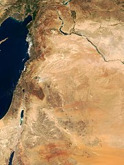
This true-color image of the region was taken on September 10, 2000, by the MODerate-resolution Imaging Spectroradiometer (MODIS) flying aboard NASA's Terra spacecraft. The image shows the lands of Israel along the eastern shore of the Mediterranean Sea, with the countries of Jordan to the southeast and Syria to the Northeast. The region known as the West Bank lies between the two countries. Running from north to south, the Jordan River links the Sea of Galilee to the Dead Sea. Click the image to enlarge it, and to see the borders drawn in. Image courtesy Jacques Descloitres, MODIS Land Group, NASA GSFC |
| 날짜 | image taken on 10. Sep. 2000 |
| 출처 | http://earthobservatory.nasa.gov/Newsroom/NewImages/Images/modis_near_east_lrg.jpg |
| 저자 | NASA, earthobservatory, http://earthobservatory.nasa.gov/ |
| 저작권 (이 파일을 인용하기) |
PD-USGov-NASA |
| 이 파일은 NASA에서 제작하였으므로 퍼블릭 도메인입니다. NASA의 저작권 정책에 따르면 NASA의 자료는 명시하지 않는 이상 저작권의 보호를 받지 않습니다. (Template:PD-USGov, 또는 NASA 저작권 정책 문서, JPL 그림 사용 정책을 참고하세요.) | ||
 |
주의사항:
|
파일 역사
날짜/시간 링크를 클릭하면 해당 시간의 파일을 볼 수 있습니다.
| 날짜/시간 | 섬네일 | 크기 | 사용자 | 설명 | |
|---|---|---|---|---|---|
| 현재 | 2015년 2월 5일 (목) 20:27 | | 2,987 × 3,967 (2.62 MB) | Capricorn4049 (토론 | 기여) | Cropped < 1 % horizontally and 1 % vertically using CropTool with precise mode. |
| 2005년 6월 5일 (일) 09:29 |  | 3,002 × 4,002 (1.96 MB) | Prolineserver (토론 | 기여) | near east, PD-USGov-NASA |
이 파일을 덮어쓸 수 없습니다.
이 파일을 사용하는 문서
다음 문서 5개가 이 파일을 사용하고 있습니다:
이 파일을 사용하고 있는 모든 위키의 문서 목록
다음 위키에서 이 파일을 사용하고 있습니다:
- ar.wikipedia.org에서 이 파일을 사용하고 있는 문서 목록
- arz.wikipedia.org에서 이 파일을 사용하고 있는 문서 목록
- ast.wikipedia.org에서 이 파일을 사용하고 있는 문서 목록
- ba.wikipedia.org에서 이 파일을 사용하고 있는 문서 목록
- ca.wikipedia.org에서 이 파일을 사용하고 있는 문서 목록
- ckb.wikipedia.org에서 이 파일을 사용하고 있는 문서 목록
- el.wikipedia.org에서 이 파일을 사용하고 있는 문서 목록
- en.wikipedia.org에서 이 파일을 사용하고 있는 문서 목록
- eo.wikipedia.org에서 이 파일을 사용하고 있는 문서 목록
- eo.wikiquote.org에서 이 파일을 사용하고 있는 문서 목록
- es.wikipedia.org에서 이 파일을 사용하고 있는 문서 목록
- eu.wikipedia.org에서 이 파일을 사용하고 있는 문서 목록
- fa.wikipedia.org에서 이 파일을 사용하고 있는 문서 목록
- fr.wikipedia.org에서 이 파일을 사용하고 있는 문서 목록
- gl.wikipedia.org에서 이 파일을 사용하고 있는 문서 목록
- he.wikipedia.org에서 이 파일을 사용하고 있는 문서 목록
- id.wikipedia.org에서 이 파일을 사용하고 있는 문서 목록
- is.wikipedia.org에서 이 파일을 사용하고 있는 문서 목록
- it.wikipedia.org에서 이 파일을 사용하고 있는 문서 목록
- ja.wikipedia.org에서 이 파일을 사용하고 있는 문서 목록
- kbp.wikipedia.org에서 이 파일을 사용하고 있는 문서 목록
- ko.wikipedia.org에서 이 파일을 사용하고 있는 문서 목록
이 파일의 더 많은 사용 내역을 봅니다.
메타데이터
분류:
- Near East
- Photos of Asia by the Terra (satellite) MODIS
- Satellite pictures of Iraq
- Satellite pictures of Israel
- Satellite pictures of the State of Palestine
- Satellite pictures of the Palestinian territories
- Satellite pictures of Jordan
- Satellite pictures of Saudi Arabia
- Maps of Iraq
- Maps of Israel
- Maps of the Levant
- Maps of Jordan
- Maps of Saudi Arabia
- Geography of Syria
- Maps of Syria
- Satellite pictures of Syria
- Greater Israel