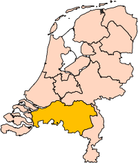
File:Noord-Brabant position.svg

לקובץ המקורי (קובץ SVG, הגודל המקורי: 200 × 236 פיקסלים, גודל הקובץ: 158 ק"ב)
כיתובים
כיתובים
תקציר
[עריכה]| תיאורNoord-Brabant position.svg | Location of the province of Noord-Brabant (North Brabant) in the Netherlands. |
| תאריך יצירה | |
| מקור | Own work, based on freely available GIS data |
| יוצר | User:Mtcv |
| אישורים והיתרים (שימוש חוזר בקובץ זה) |
Data: attribution required; my work: PD |
| גרסאות אחרות | I attempted to make an svg version of Image:Noord Brabant-Position.png (with less simplified boundaries) |
Clickable version
[עריכה]
רישיון
[עריכה]
|
בעלי זכויות היוצרים על הקובץ הזה, Centraal Bureau voor de Statistiek, מאשרים לכולם להשתמש בו לכל מטרה, בתנאי שניתן לבעלי הזכויות ייחוס נאות. הפצה, יצירות נגזרות, שימושים מסחריים וכל שימוש אחר מותרים. |
|
Attribution |
|
אישור השימוש בקובץ זה / קבצים אלה עבר וידוא, המאוחסן במערכת VRT. הוא זמין תחת כרטיס מספר #2007041210008226 עבור משתמשים בעלי גישה למערכת זו. כדי לוודא את האישור, אנא פנו למשתמשים בעלי גישה ל-VRT. הקישור לכרטיס : https://ticket.wikimedia.org/otrs/index.pl?Action=AgentTicketZoom&TicketNumber=2007041210008226
|
| This image is (in part or entirely) based on geographical data from Statistics Netherlands (Centraal Bureau voor de Statistiek). Digital geometry files in ESRI format can be downloaded from their website [1].
In particular, boundary data of statistical districts is based on either the Wijk- en buurtkaart 2005, or the Wijk- en buurtkaart 2003 ("CBS/TOPgrenzen"). Data on localities (bevolkingskernen) are from the publication Bevolkingskernen in Nederland 2001. Conditions of use (in Dutch):
Unless otherwise specified, data on waterways and lakes are from the public domain Digital Chart of the World. |
| Annotations InfoField | This image is annotated: View the annotations at Commons |
היסטוריית הקובץ
ניתן ללחוץ על תאריך/שעה כדי לראות את הקובץ כפי שנראה באותו זמן.
| תאריך/שעה | תמונה ממוזערת | ממדים | משתמש | הערה | |
|---|---|---|---|---|---|
| נוכחית | 17:20, 2 במרץ 2019 |  | 236 × 200 (158 ק"ב) | Thayts (שיחה | תרומות) | update |
| 00:49, 3 באוקטובר 2006 |  | 236 × 200 (158 ק"ב) | Mtcv (שיחה | תרומות) | {{Information| |Description=Location of the province of Noord-Holland (North Holland) in the Netherlands. |Source=Own work, based on freely available GIS data |Date=2006-10-03 |Author=User:Mtcv |Permission=Data: attribution required; my work: PD |othe |
אין באפשרותך לדרוס את הקובץ הזה.
שימוש בקובץ
הדפים הבאים משתמשים בקובץ הזה:
- Maps of the Netherlands
- File:Drenthe position.svg
- File:Flevoland position.svg
- File:Friesland position.svg
- File:Gelderland position.svg
- File:Groningen position.svg
- File:Limburg position.svg
- File:Noord-Brabant position.svg
- File:Noord-Holland position.svg
- File:Overijssel position.svg
- File:Provinces of the Netherlands.svg
- File:Utrecht position.svg
- File:Zeeland position.svg
- File:Zuid-Holland position.svg
שימוש גלובלי בקובץ
אתרי הוויקי השונים הבאים משתמשים בקובץ זה:
- שימוש באתר ar.wikipedia.org
- شمال بربنت
- آيندهوفن
- بريدا
- بارله ناساو
- تيلبورخ
- سيرتوخيمبوس
- قالب:بلديات شمال برابنت
- آلبورخ
- ألفن- كام
- أستن
- بيرخ آيك
- فيلدهوفن
- بيرخن أوب زووم
- بيرنهيزه
- بيست (هولندا)
- بلادل
- بوكل
- بوكسمير
- بوكستل
- كرانندونك
- كاوك
- دورنه
- دونجن
- دريميلين
- إيرسل
- إيتن- لور
- خيرتراودنبيرخ
- خيلدروب- ميرلو
- خيميرت- باكل
- خيلزه آن راين
- خورلا
- خرافه (هولندا)
- هارن (شمال برابنت)
- هالدربيرخه
- هيزه- لينده
- هيلموند
- هوسدن
- هيلفارينبيك
- لاربيك
- لانديرد
- لوب أوب زند
- مل آن سينت هوبرت
- موردايك
- نونن (خيرفن آن نيدرفيتن)
- أويرشخوت
- أويسترفايك
- أوسترهاوت
- أوس (هولندا)
- روسل- دي ميردن
- روسيندال
צפייה בשימושים גלובליים נוספים של קובץ זה.
מטא־נתונים
קובץ זה מכיל מידע נוסף, שכנראה הגיע ממצלמה דיגיטלית או מסורק שבהם הקובץ נוצר או עבר דיגיטציה.
אם הקובץ שונה ממצבו הראשוני, כמה מהנתונים להלן עלולים שלא לשקף באופן מלא את הקובץ הנוכחי.
| רוחב | 200 |
|---|---|
| גובה | 236 |


