File:Nuclear weapons test (North Korea, 2009-05-25).jpg
קפיצה לניווט
קפיצה לחיפוש
אין גרסה ברזולוציה גבוהה יותר.
Nuclear_weapons_test_(North_Korea,_2009-05-25).jpg (409 × 569 פיקסלים, גודל הקובץ: 73 ק"ב, סוג MIME: image/jpeg)
כיתובים
כיתובים
נא להוסיף משפט שמסביר מה הקובץ מייצג
תקציר
[עריכה].jpg&action=edit§ion=1)
| תיאור |
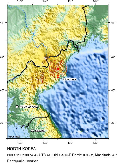
English: earthquake at 41.306°N, 129.029°E (North Korea) related to news that North Korea had performed a nuclear test which has been confirmed by both North Korea and Russia.
Event-ID: us2009hbaf location: 70 km (45 miles) NNW of Kimchaek, North Korea time: 09:54:43 AM at epicenter magnitude: 4.7 (GS) depth: ? |
| תאריך יצירה | |
| מקור | http://neic.usgs.gov/neis/eq_depot/2009/eq_090525_hbaf/neic_hbaf_l.html (USGS NEIC (WDCS-D)) |
| יוצר | United States Geological Survey (USGS) |
רישיון
[עריכה].jpg&action=edit§ion=2)
This image is in the public domain in the United States because it only contains materials that originally came from the United States Geological Survey, an agency of the United States Department of the Interior. For more information, see the official USGS copyright policy.
|
היסטוריית הקובץ
ניתן ללחוץ על תאריך/שעה כדי לראות את הקובץ כפי שנראה באותו זמן.
| תאריך/שעה | תמונה ממוזערת | ממדים | משתמש | הערה | |
|---|---|---|---|---|---|
| נוכחית | 19:51, 25 במאי 2009 | | 569 × 409 (73 ק"ב) | Wolf-Dieter (שיחה | תרומות) | {{Information |Description={{en|1=earthquake at 41.306°N, 129.029°E (North Korea) related to news that North Korea had performed a nuclear test which has been confirmed by both North Korea and Russia. Event-ID: us2009hbaf location: 70 km (45 miles) NNW |
אין באפשרותך לדרוס את הקובץ הזה.
שימוש בקובץ
אין דפים המשתמשים בקובץ זה.
שימוש גלובלי בקובץ
אתרי הוויקי השונים הבאים משתמשים בקובץ זה:
- שימוש באתר ar.wikipedia.org
- שימוש באתר ca.wikipedia.org
- שימוש באתר ckb.wikipedia.org
- שימוש באתר cs.wikipedia.org
- שימוש באתר de.wikinews.org
- שימוש באתר en.wikipedia.org
- שימוש באתר fa.wikipedia.org
- שימוש באתר he.wikipedia.org
- שימוש באתר ko.wikipedia.org
- שימוש באתר mzn.wikipedia.org
- שימוש באתר nl.wikipedia.org
- שימוש באתר www.wikidata.org
- שימוש באתר zh.wikipedia.org
.jpg&oldid=720804495)