File:Péninsule ibérique en 1224.png
Vai alla navigazione
Vai alla ricerca

Dimensioni di questa anteprima: 800 × 600 pixel. Altre risoluzioni: 320 × 240 pixel | 640 × 480 pixel | 1 024 × 768 pixel | 1 280 × 960 pixel | 2 000 × 1 500 pixel.
File originale (2 000 × 1 500 pixel, dimensione del file: 935 KB, tipo MIME: image/png)
Didascalie
Didascalie
Aggiungi una brevissima spiegazione di ciò che questo file rappresenta
Dettagli
[modifica]
| Descrizione |
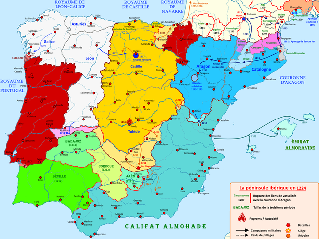
Français : Carte de la péninsule ibérique en 1224 illustrant les principaux évènements de l'époque |
| Data | |
| Fonte | Opera propria |
| Autore | Elryck |
Licenza
[modifica]
Io, detentore del copyright su quest'opera, dichiaro di pubblicarla con la seguente licenza:
Questo file è disponibile in base alla licenza Creative Commons Attribuzione-Condividi allo stesso modo 4.0 Internazionale
- Tu sei libero:
- di condividere – di copiare, distribuire e trasmettere quest'opera
- di modificare – di adattare l'opera
- Alle seguenti condizioni:
- attribuzione – Devi fornire i crediti appropriati, un collegamento alla licenza e indicare se sono state apportate modifiche. Puoi farlo in qualsiasi modo ragionevole, ma non in alcun modo che suggerisca che il licenziante approvi te o il tuo uso.
- condividi allo stesso modo – Se remixi, trasformi o sviluppi il materiale, devi distribuire i tuoi contributi in base alla stessa licenza o compatibile all'originale.
Cronologia del file
Fare clic su un gruppo data/ora per vedere il file come si presentava nel momento indicato.
| Data/Ora | Miniatura | Dimensioni | Utente | Commento | |
|---|---|---|---|---|---|
| attuale | 15:15, 27 ago 2020 | | 2 000 × 1 500 (935 KB) | Elryck (discussione | contributi) | Ajout des pogroms |
| 07:44, 19 ago 2020 |  | 2 000 × 1 500 (924 KB) | Elryck (discussione | contributi) | Correction de la couleur d'empuries | |
| 13:05, 18 ago 2020 |  | 2 000 × 1 500 (925 KB) | Elryck (discussione | contributi) | Uploaded own work with UploadWizard |
Impossibile sovrascrivere questo file.
Utilizzo del file
Le seguenti 2 pagine usano questo file:
Utilizzo globale del file
Anche i seguenti wiki usano questo file:
- Usato nelle seguenti pagine di an.wikipedia.org:
- Usato nelle seguenti pagine di en.wikipedia.org:
- Usato nelle seguenti pagine di es.wikipedia.org:
- Usato nelle seguenti pagine di fr.wikipedia.org:
- Alphonse VIII
- Almohades
- Couronne d'Aragon
- Jacques Ier (roi d'Aragon)
- Ferdinand III (roi de Castille)
- Alphonse IX
- Pierre II (roi d'Aragon)
- Sanche Ier (roi de Portugal)
- Alphonse II (roi de Portugal)
- Histoire du Portugal
- Royaume de Castille
- Royaume de Navarre
- Henri Ier (roi de Castille)
- Royaume de León
- Histoire d'al-Andalus
- Taïfa de Séville
- Sanche VII
- Reconquista
- Troisième période de taïfas
- Histoire de l'Aragon
- Taïfa de Cordoue
- Utilisateur:Mathious Ier/Histoire du Portugal (Brouillon)
- Usato nelle seguenti pagine di it.wikipedia.org:
Metadati
Categorie:
- French-language maps showing history of Europe
- Maps of 13th-century Iberian Peninsula
- Reconquista maps of the Iberian Peninsula
- Iberian kingdoms
- Maps of Al-Andalus
- Maps of the Kingdom of León
- Maps of the taifa kingdoms
- Maps of the Almohad Caliphate
- Territorial evolution of Spain
- Maps of the Crown of Aragon
- Maps of the Kingdom of Castile