File:Palestine - annual report - department of agriculture & forests.Compiled to 15th October 1929 01 (FL184566740 0981528).jpg
קפיצה לניווט
קפיצה לחיפוש

גודל התצוגה המקדימה הזאת: 528 × 600 פיקסלים. רזולוציות אחרות: 211 × 240 פיקסלים | 423 × 480 פיקסלים | 676 × 768 פיקסלים | 902 × 1,024 פיקסלים | 1,803 × 2,048 פיקסלים | 13,887 × 15,770 פיקסלים.
לקובץ המקורי (13,887 × 15,770 פיקסלים, גודל הקובץ: 237.12 מ"ב, סוג MIME: image/jpeg)
כיתובים
כיתובים
נא להוסיף משפט שמסביר מה הקובץ מייצג
תקציר
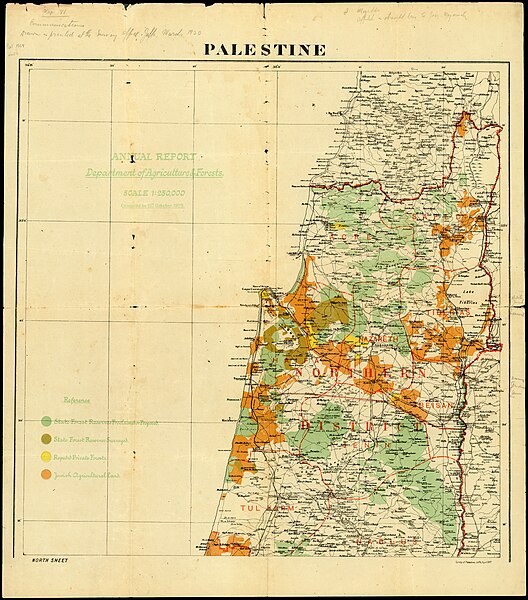
[עריכה]| Palestine - annual report - department of agriculture & forests.Compiled to 15th October 1929
( |
||||||||||||||||||||||||
|---|---|---|---|---|---|---|---|---|---|---|---|---|---|---|---|---|---|---|---|---|---|---|---|---|
| כותרת |
Palestine - annual report - department of agriculture & forests.Compiled to 15th October 1929 |
|||||||||||||||||||||||
| מפרסם |
Survey of Palestine |
|||||||||||||||||||||||
| תיאור |
Palestine - annual report - department of agriculture & forests : Compiled to 15th October 1929. Survey of Palestine 1927. |
|||||||||||||||||||||||
| שפה | אנגלית | |||||||||||||||||||||||
| תאריך הוצאה לאור | מ- 1927 עד 1929 | |||||||||||||||||||||||
| טכניקה | 2 sheets : color ; | |||||||||||||||||||||||
| ממדים | 66 × 58 ס"מ | |||||||||||||||||||||||
| אוסף |
|
|||||||||||||||||||||||
| מיקום נוכחי |
|
|||||||||||||||||||||||
| מיקום הוצאה | יפו | |||||||||||||||||||||||
| חיפוש בקטלוג מרחב | יפו | |||||||||||||||||||||||
| הערות | Includes indication to sub-districts boundaries.; Includes indication of Jewish agricultural lands, and of forests lands. | |||||||||||||||||||||||
| קנה מידה | 1:250,000 cm | |||||||||||||||||||||||
| IE PID | IE184566738 | |||||||||||||||||||||||
| רוזטה שם קובץ | FL184566740 | |||||||||||||||||||||||
| מזהה רשומה בספרייה הלאומית (P3959) | 997009815286305171 | |||||||||||||||||||||||
| חיפוש בקטלוג מרחב | אנגלית | |||||||||||||||||||||||
| חיפוש בקטלוג מרחב | Forests and forestryILand capability for agricultureIAdministrative and political divisionsMapsIsraelSurvey of Palestine | |||||||||||||||||||||||
| מקור/צלם |
|
|||||||||||||||||||||||
| גרסאות אחרות | ||||||||||||||||||||||||
| Jpg / Tif version |
|
|||||||||||||||||||||||

.jpg)

.jpg&action=edit§ion=1)
רישיון
[עריכה].jpg&action=edit§ion=2)
This work created by the United Kingdom Government is in the public domain.
This is because it is one of the following:
HMSO has declared that the expiry of Crown Copyrights applies worldwide (ref: HMSO Email Reply)
|
 |
יצירה זו נוצרה על-ידי מדינת ישראל או הוזמנה על־ידיה, והיא נמצאת בנחלת־הכלל כיוון שהיא עונה על אחד התנאים הקבועים בחוק זכות יוצרים, התשס"ח-2007 בנוגע לפקיעת זכויות היוצרים של המדינה:
|

|
[[Category:]]
היסטוריית הקובץ
ניתן ללחוץ על תאריך/שעה כדי לראות את הקובץ כפי שנראה באותו זמן.
| תאריך/שעה | תמונה ממוזערת | ממדים | משתמש | הערה | |
|---|---|---|---|---|---|
| נוכחית | 03:20, 31 באוגוסט 2023 | | 15,770 × 13,887 (237.12 מ"ב) | Geagea (שיחה | תרומות) | pattypan 22.03 |
אין באפשרותך לדרוס את הקובץ הזה.
שימוש בקובץ
הדף הבא משתמש בקובץ הזה:
.jpg&oldid=800808398)