File:Pentagon road network map 1945.jpg
קפיצה לניווט
קפיצה לחיפוש

גודל התצוגה המקדימה הזאת: 470 × 599 פיקסלים. רזולוציות אחרות: 188 × 240 פיקסלים | 377 × 480 פיקסלים | 1,020 × 1,300 פיקסלים.
לקובץ המקורי (1,020 × 1,300 פיקסלים, גודל הקובץ: 535 ק"ב, סוג MIME: image/jpeg)
כיתובים
כיתובים
נא להוסיף משפט שמסביר מה הקובץ מייצג
This image is in the public domain in the United States because it only contains materials that originally came from the United States Geological Survey, an agency of the United States Department of the Interior. For more information, see the official USGS copyright policy.
|
| תיאור |
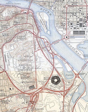
USGS topos covering the area around the Pentagon in Virginia, soon after the road network was built. Note that the Shirley Highway near the south edge of the map was added later, as it opened in 1943. |
|||||||||
| מקור |
|
|||||||||
| Geotemporal data | ||||||||||
| Bounding box |
|
|||||||||
| Georeferencing | ||||||||||
היסטוריית הקובץ
ניתן ללחוץ על תאריך/שעה כדי לראות את הקובץ כפי שנראה באותו זמן.
| תאריך/שעה | תמונה ממוזערת | ממדים | משתמש | הערה | |
|---|---|---|---|---|---|
| נוכחית | 19:31, 21 בינואר 2006 | | 1,300 × 1,020 (535 ק"ב) | SPUI~commonswiki (שיחה | תרומות) | {{PD-USGov-USGS}} USGS topos covering the area around the Pentagon in Virginia, soon after the road network was built. Note that the Shirley Highway near the southwest edge of the map was added later, as it opened in 1943. *North half: [http://historical. |
אין באפשרותך לדרוס את הקובץ הזה.
שימוש בקובץ
הדפים הבאים משתמשים בקובץ הזה:
שימוש גלובלי בקובץ
אתרי הוויקי השונים הבאים משתמשים בקובץ זה:
- שימוש באתר ar.wikipedia.org
- שימוש באתר ast.wikipedia.org
- שימוש באתר ca.wikipedia.org
- שימוש באתר da.wikipedia.org
- שימוש באתר de.wikipedia.org
- שימוש באתר el.wikipedia.org
- שימוש באתר en.wikipedia.org
- שימוש באתר et.wikipedia.org
- שימוש באתר ga.wikipedia.org
- שימוש באתר he.wikipedia.org
- שימוש באתר hr.wikipedia.org
- שימוש באתר hy.wikipedia.org
- שימוש באתר it.wikipedia.org
- שימוש באתר ja.wikipedia.org
- שימוש באתר kn.wikipedia.org
- שימוש באתר pl.wikipedia.org
- שימוש באתר pnb.wikipedia.org
- שימוש באתר tr.wikipedia.org
- שימוש באתר uz.wikipedia.org
- שימוש באתר www.wikidata.org
מטא־נתונים
קטגוריות:
- 1945 maps of Washington, D.C.
- 1945 maps of Virginia
- Road maps of the United States
- Interstate 395 in Arlington County, Virginia
- The Pentagon
- Maps of Arlington National Cemetery
- Maps of rivers in Washington, D.C.
- Boundary Channel (Potomac River)
- Virginia State Route 110
- Virginia State Route 27
- The Pentagon in 1945