File:Ph regions and provinces.svg
둘러보기로 이동
검색으로 이동

SVG 파일의 PNG 형식의 미리보기 크기: 412 × 599 픽셀. 다른 해상도: 165 × 240 픽셀 | 330 × 480 픽셀 | 528 × 768 픽셀 | 704 × 1,024 픽셀 | 1,409 × 2,048 픽셀 | 4,200 × 6,105 픽셀
원본 파일 (SVG 파일, 실제 크기 4,200 × 6,105 픽셀, 파일 크기: 2.97 MB)
캡션
설명
이 파일이 나타내는 바에 대한 한 줄 설명을 추가합니다
파일 설명[편집]
| 설명 |
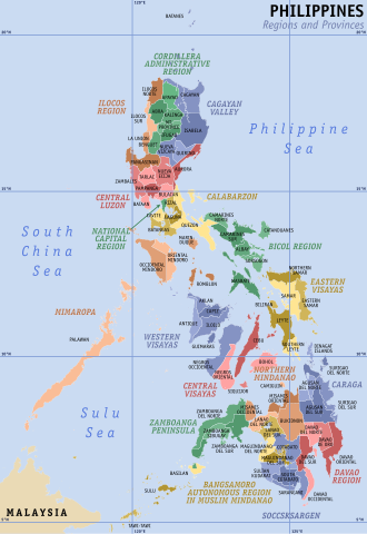
English: Map of the Philippines showing the location of all the regions and provinces.
Notes: The map does not depict cities that are independent of any province. It also does not depict the status of Sabah, the Spratly Islands, and Scarborough Shoal as disputed Philippine territories. |
| 날짜 | |
| 출처 | Own work, based on seav's Ph regions and provinces.png and Felipe Aira's File:PhlMapCit.svg |
| 저자 | HueMan1 |
| 다른 버전 |
|

라이선스[편집]
HueMan1은(는) 아래 작품의 저작권자로서, 해당 저작물을 다음과 같은 라이선스로 배포합니다:

|
GNU 자유 문서 사용 허가서 1.2판 또는 자유 소프트웨어 재단에서 발행한 이후 판의 규정에 따라 본 문서를 복제하거나 개작 및 배포할 수 있습니다. 본 문서에는 변경 불가 부분이 없으며, 앞 표지 구절과 뒷 표지 구절도 없습니다. 본 사용 허가서의 전체 내용은 GNU 자유 문서 사용 허가서 부분에 포함되어 있습니다. |
파일 역사
날짜/시간 링크를 클릭하면 해당 시간의 파일을 볼 수 있습니다.
| 날짜/시간 | 섬네일 | 크기 | 사용자 | 설명 | |
|---|---|---|---|---|---|
| 현재 | 2023년 7월 23일 (일) 05:49 | | 4,200 × 6,105 (2.97 MB) | Hariboneagle927 (토론 | 기여) | + Maguindanao division |
| 2023년 3월 11일 (토) 23:58 |  | 4,200 × 6,105 (2.95 MB) | Hariboneagle927 (토론 | 기여) | Bangsamoro SGA in Cotabato (since Lamitan is shown as part of Zamboanga Peninsula in this map) | |
| 2019년 12월 10일 (화) 15:58 |  | 4,200 × 6,105 (2.94 MB) | HueMan1 (토론 | 기여) | Renamed Compostela Valley to Davao de Oro. | |
| 2019년 8월 9일 (금) 05:09 |  | 4,200 × 6,105 (2.95 MB) | HueMan1 (토론 | 기여) | Minor fixes | |
| 2019년 7월 19일 (금) 12:26 |  | 4,200 × 6,105 (2.95 MB) | HueMan1 (토론 | 기여) | Minor fixes | |
| 2019년 7월 1일 (월) 10:10 |  | 4,200 × 6,105 (2.95 MB) | HueMan1 (토론 | 기여) | User created page with UploadWizard |
이 파일을 덮어쓸 수 없습니다.
이 파일을 사용하는 문서
다음 문서 2개가 이 파일을 사용하고 있습니다:
이 파일을 사용하고 있는 모든 위키의 문서 목록
다음 위키에서 이 파일을 사용하고 있습니다:
- an.wikipedia.org에서 이 파일을 사용하고 있는 문서 목록
- bcl.wikipedia.org에서 이 파일을 사용하고 있는 문서 목록
- be-tarask.wikipedia.org에서 이 파일을 사용하고 있는 문서 목록
- el.wikipedia.org에서 이 파일을 사용하고 있는 문서 목록
- en.wikipedia.org에서 이 파일을 사용하고 있는 문서 목록
- Mindanao
- Philippines
- Spratly Islands
- Luzon
- Metro Manila
- Visayas
- Provinces of the Philippines
- Manila
- Barangay
- Regions of the Philippines
- Cities of the Philippines
- Wikipedia:WikiProject Philippine LGUs/Province template
- Municipalities of the Philippines
- Southern Tagalog
- Quezon City
- Lanao del Sur
- Autonomous Region in Muslim Mindanao
- Valenzuela, Metro Manila
- Kalayaan, Palawan
- List of cities and municipalities in the Philippines
- Portal:Philippines
- Administrative divisions of the Philippines
- Template:Administrative divisions of the Philippines
- Portal:Philippines/Topics
- Territories claimed by the Philippines
- Legislative districts of the Philippines
- Talk:Philippines/Archive 7
- Internal Revenue Allotment
- Outline of the Philippines
- Wikipedia talk:Tambayan Philippines/Archive 16
- Barangay captain
- List of primary local government units of the Philippines
- Template:English official language clickable map/testcases
- Partido (historical province)
- Barangay hall
- Bangsamoro
- Barangay elections
- Negros
- User:Dgfddfgs/sandbox
- Autonomous regions of the Philippines
- User:Sanglahi86/sandbox
- Negros Island Region
- Sub-provinces of the Philippines
- User:Jcisawesomeguy/sandbox
- Special Geographic Area
- Caburacanan
이 파일의 더 많은 사용 내역을 봅니다.