Category:SVG maps of regions of the Philippines
Jump to navigation
Jump to search
Subcategories
This category has the following 3 subcategories, out of 3 total.
Media in category "SVG maps of regions of the Philippines"
The following 17 files are in this category, out of 17 total.
-
 Blank map of the Philippines (primary LGUs).svg 512 × 561; 1.35 MB
-
 COVID-19 pandemic cases in Bangsamoro.svg 2,642 × 1,358; 99 KB
-
 COVID-19 pandemic cases in Calabarzon.svg 802 × 762; 70 KB
-
 COVID-19 pandemic cases in Central Luzon.svg 862 × 751; 52 KB
-
 COVID-19 pandemic cases in the Davao Region.svg 549 × 968; 25 KB
-
 COVID-19 pandemic cases in the Philippines by region (per capita).svg 4,200 × 6,105; 2.02 MB
-
 COVID-19 pandemic cases in the Philippines by region.svg 4,200 × 6,105; 2.02 MB
-
 Federal Republic of the Philippines map (2018 Consultative Committee proposal).svg 1,871 × 2,468; 1.44 MB
-
 Map of Bangsamoro (local government units).svg 1,006 × 580; 1.48 MB
-
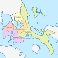 Map of Calabarzon (local government units).svg 512 × 512; 802 KB
-
 Ph administrative map blank.svg 3,937 × 5,723; 1.19 MB
-
 PH Administrative Map lv.svg 512 × 561; 1.67 MB
-
 PH Administrative Map.svg 512 × 561; 2.2 MB
-
 Ph regions and provinces blank.svg 4,200 × 6,105; 2.93 MB
-
 Ph regions and provinces.svg 4,200 × 6,105; 2.97 MB
-
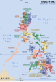
 Provinces of the Philippines.svg 840 × 1,221; 1.92 MB
-
 Regions and provinces of the Philippines-es.svg 512 × 744; 1.42 MB


.svg)

.svg)
.svg)
.svg)


.svg)