File:Principality of Orange (1633).png
둘러보기로 이동
검색으로 이동
미리 보기 크기: 800 × 560 픽셀 다른 해상도: 320 × 224 픽셀 | 640 × 448 픽셀 | 1,024 × 716 픽셀 | 1,280 × 895 픽셀 | 2,276 × 1,592 픽셀
원본 파일 (2,276 × 1,592 픽셀, 파일 크기: 9.11 MB, MIME 종류: image/png)
캡션
설명
이 파일이 나타내는 바에 대한 한 줄 설명을 추가합니다
파일 설명
[편집].png&action=edit§ion=1)
| 설명 |
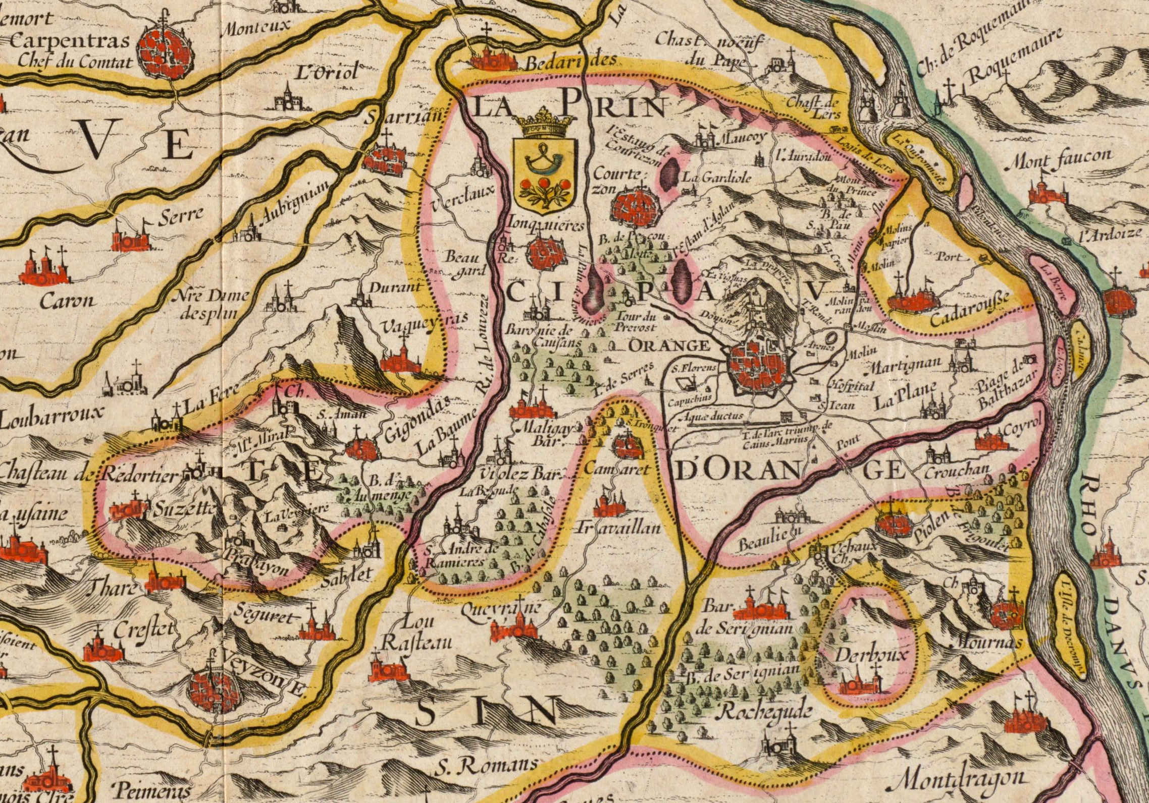
English: Territory of the Principality of Orange. Cropped from a Jan Jansson map from 1633 titled La Principauté d'Orange et comtat de Venaissin. On this map, the south is at the top and the north at the bottom, which explains why the Rhone River is on the right and the city of Carpentras on the left. |
| 날짜 | |
| 출처 | Digital Commonwealth Massachusetts Collection Online |
| 저자 | Jan Jansson (1588-1664) |
라이선스
[편집].png&action=edit§ion=2)
|
이 작품은 미국, 그리고 저작권 보호 기간이 저작자 사후 100년, 또는 그 이하인 모든 국가에서 퍼블릭 도메인입니다. | |
| 이 저작물은 모든 저작인접권을 포함한 저작권법하의 규제로부터 자유로운 것으로 확인되었습니다. | |
파일 역사
날짜/시간 링크를 클릭하면 해당 시간의 파일을 볼 수 있습니다.
| 날짜/시간 | 섬네일 | 크기 | 사용자 | 설명 | |
|---|---|---|---|---|---|
| 현재 | 2019년 9월 14일 (토) 08:51 | | 2,276 × 1,592 (9.11 MB) | Jfblanc (토론 | 기여) | Updrate cropping including the whole Derboux enclave area. |
| 2016년 11월 26일 (토) 19:20 |  | 1,226 × 687 (2.46 MB) | Lubiesque (토론 | 기여) | User created page with UploadWizard |
이 파일을 덮어쓸 수 없습니다.
이 파일을 사용하는 문서
이 파일을 사용하는 문서가 없습니다.
이 파일을 사용하고 있는 모든 위키의 문서 목록
다음 위키에서 이 파일을 사용하고 있습니다:
- azb.wikipedia.org에서 이 파일을 사용하고 있는 문서 목록
- en.wikipedia.org에서 이 파일을 사용하고 있는 문서 목록
- fy.wikipedia.org에서 이 파일을 사용하고 있는 문서 목록
- it.wikipedia.org에서 이 파일을 사용하고 있는 문서 목록
- ko.wikipedia.org에서 이 파일을 사용하고 있는 문서 목록
- vi.wikipedia.org에서 이 파일을 사용하고 있는 문서 목록
.png&oldid=674893410)