File:Pyrenees topographic map-fr.svg
둘러보기로 이동
검색으로 이동

SVG 파일의 PNG 형식의 미리보기 크기: 800 × 475 픽셀. 다른 해상도: 320 × 190 픽셀 | 640 × 380 픽셀 | 1,024 × 608 픽셀 | 1,280 × 760 픽셀 | 2,560 × 1,520 픽셀 | 3,200 × 1,900 픽셀
원본 파일 (SVG 파일, 실제 크기 3,200 × 1,900 픽셀, 파일 크기: 6.3 MB)
캡션
설명
이 파일이 나타내는 바에 대한 한 줄 설명을 추가합니다
![]()
Detailed map of large dimension. For a better viewing, click on the link of the image above.
Carte détaillée de grande dimension. Pour une visualisation optimale, cliquer sur le lien de l'image ci-dessus.
파일 설명
[편집]| 묘사 |
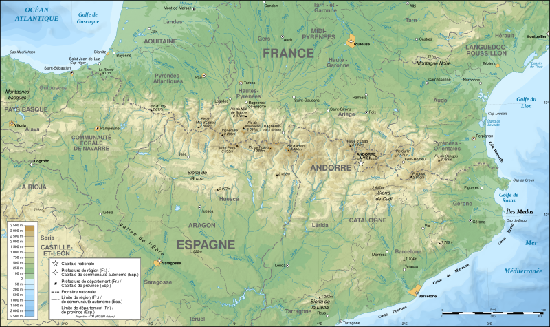
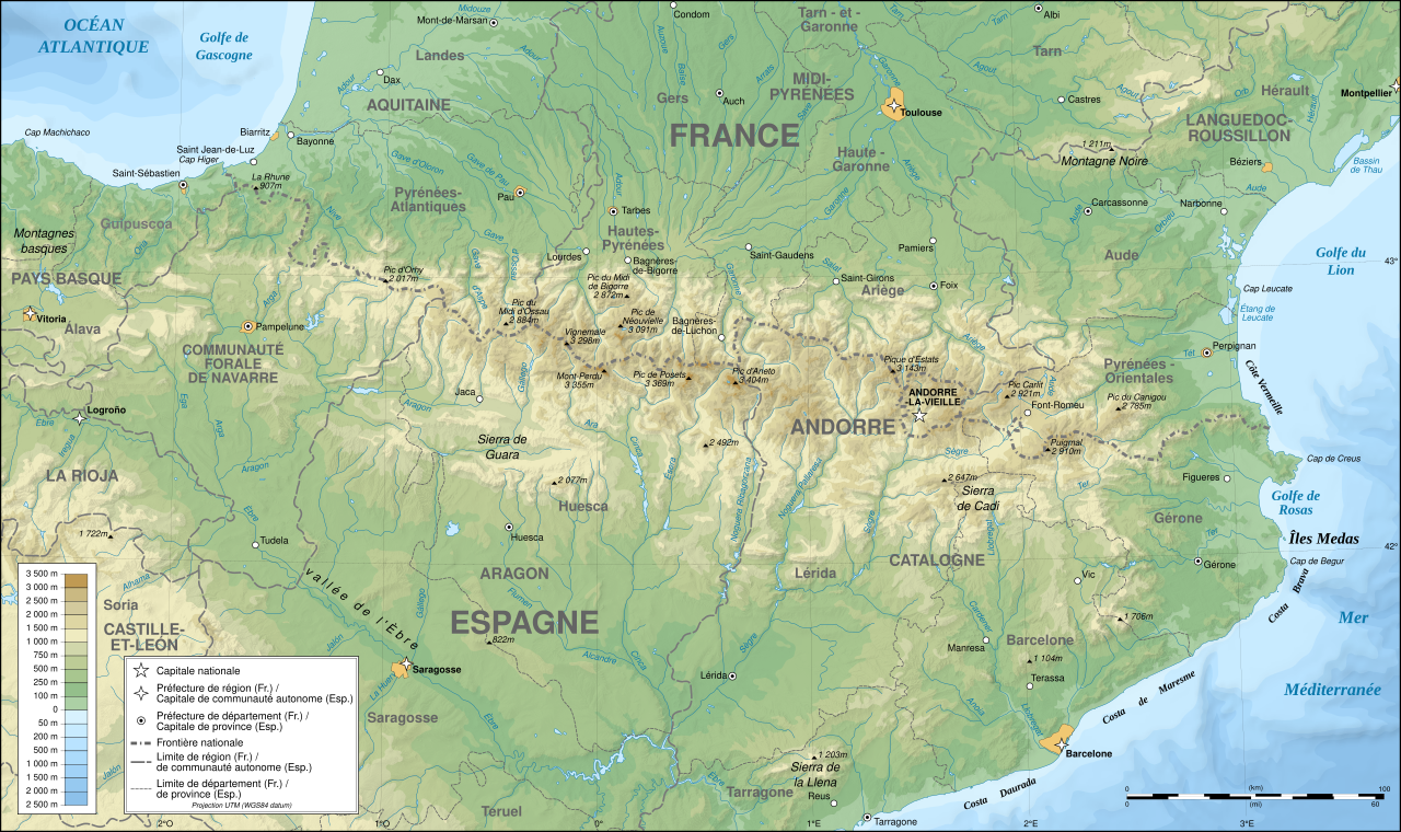
English: Topographic map in French of the Pyrenees mountains.
Note: The shaded relief is a raster image embedded in the SVG file. Français : Carte topographique des Pyrénées en francais.
Note : Le relief ombré est une image bitmap embarquée dans le fichier SVG. Português: Mapa topográfico (em Francês) dos Pirenéus.
Español: Mapa topográfico (en francés) de los Pirineos.
UTM projection; WGS84 datum; shaded relief (composite image of N-W, W and N lightning positions);
|
||
| SVG 발전 | |||
| 날짜 | May 2007 (modified September 2008) | ||
| 출처 |
Own work;
|
||
| 창작자 | |||
| 저작권 (이 파일을 인용하기) |
|
||
| 지리 참고 | 부적절한 경우에 숨기려면 warp_status = skip로 설정하세요. | ||
| 다른 버전 |
[]
|


수상
[편집]
|

이 이미지는 2007년 8월 1일의 오늘의 이미지로 선정되었습니다. 이미지 설명은 다음과 같습니다. 다른 언어들:
Čeština: Francouzská mapa pohoří Pyreneje Dansk: Topografisk kort over Pyrenæerne på fransk. English: Topographic map in French of the Pyrenees mountains. Français : Carte topographique des Pyrénées en français. Magyar: A Pireneusok térképe Nederlands: Franse Topografische kaart van de Pyreneeën Português: Um mapa topográfico em francês, da região dos Pireneus. Română: Hartă topografică a munților Pirinei, Franța. Suomi: Topografinen kartta Ranskasta, Pyreneiden vuorilta. Svenska: Topografisk karta över Pyrenéerna på franska. Русский: Топографическая карта Пиренеев. Українська: Топографічна карта Піренеїв 中文: 法语注释的比利牛斯山地形图 中文(繁體): 庇里牛斯山的法語地形圖 עברית : מפה טופוגרפית בצרפתית של הרי הפירינאים |
라이선스
[편집]
나는 아래 작품의 저작권자로서, 이 저작물을 다음과 같은 라이선스로 배포합니다:

|
GNU 자유 문서 사용 허가서 1.2판 또는 자유 소프트웨어 재단에서 발행한 이후 판의 규정에 따라 본 문서를 복제하거나 개작 및 배포할 수 있습니다. 본 문서에는 변경 불가 부분이 없으며, 앞 표지 구절과 뒷 표지 구절도 없습니다. 본 사용 허가서의 전체 내용은 GNU 자유 문서 사용 허가서 부분에 포함되어 있습니다. |
| 이 파일은 크리에이티브 커먼즈 저작자표시-동일조건변경허락 3.0 Unported 라이선스로 배포됩니다. | ||
| ||
| 이 라이선스 틀은 GFDL 라이선스 변경의 일부로 이 파일에 추가되었습니다. |
- 이용자는 다음의 권리를 갖습니다:
- 공유 및 이용 – 저작물의 복제, 배포, 전시, 공연 및 공중송신
- 재창작 – 저작물의 개작, 수정, 2차적저작물 창작
- 다음과 같은 조건을 따라야 합니다:
- 저작자표시 – 적절한 저작자 표시를 제공하고, 라이센스에 대한 링크를 제공하고, 변경사항이 있는지를 표시해야 합니다. 당신은 합리적인 방식으로 표시할 수 있지만, 어떤 방식으로든 사용권 허가자가 당신 또는 당신의 사용을 지지하는 방식으로 표시할 수 없습니다.
- 동일조건변경허락 – 만약 당신이 이 저작물을 리믹스 또는 변형하거나 이 저작물을 기반으로 제작하는 경우, 당신은 당신의 기여물을 원저작물과 동일하거나 호환 가능한 라이선스에 따라 배포하여야 합니다.
이 라이선스 중에서 목적에 맞는 것을 선택하여 사용할 수 있습니다.
파일 역사
날짜/시간 링크를 클릭하면 해당 시간의 파일을 볼 수 있습니다.
| 날짜/시간 | 섬네일 | 크기 | 사용자 | 설명 | |
|---|---|---|---|---|---|
| 현재 | 2012년 12월 14일 (금) 00:05 | | 3,200 × 1,900 (6.3 MB) | Benh (토론 | 기여) | uses Helvetica over Arial when available. |
| 2008년 9월 23일 (화) 15:49 |  | 3,200 × 1,900 (6.3 MB) | Sting (토론 | 기여) | Using ETOPO1 data for bathymetry; new standard colors | |
| 2007년 7월 2일 (월) 00:25 |  | 3,200 × 1,900 (5.9 MB) | Sting (토론 | 기여) | + projection info in key ; + major cities areas ; some corrections in the rivers | |
| 2007년 6월 25일 (월) 20:30 |  | 3,200 × 1,900 (5.88 MB) | Sting (토론 | 기여) | + key for borders | |
| 2007년 5월 31일 (목) 21:18 |  | 3,200 × 1,900 (5.88 MB) | Sting (토론 | 기여) | Some corrections | |
| 2007년 5월 30일 (수) 18:23 |  | 3,200 × 1,900 (5.88 MB) | Sting (토론 | 기여) | {{Information |Description=Topographic map in French of the Pyrenees mountains |Source=Own work ;<br/>Topographic map : [http://www2.jpl.nasa.gov/srtm NASA Shuttle Radar Topography Mission] (SRTM3 v.2) (public domain) edited with [http:// |
이 파일을 덮어쓸 수 없습니다.
이 파일을 사용하는 문서
다음 문서 78개가 이 파일을 사용하고 있습니다:
- Pyrenees
- User:Bryan/POTY2007-alt
- User:Giorgi Balakhadze/Gallery
- User:JoKalliauer/SVG test suites/Featured details
- User:Pfctdayelise/POTY07 categories/2007 list
- User:Pfctdayelise/POTY07 categories/Diagrams, coats of arms, art and illustrations
- User:Scratchinghead
- User:Sting/Gallery: Regional maps
- User talk:Ayack/Archives 1
- User talk:Sting/Archive 01
- Commons:Bistro/archives/juin 2007
- Commons:Featured picture candidates/File:Settlement map of the Greek tribes before the start of the Peloponnesian War-ru.png
- Commons:Featured picture candidates/Image:Pyrenees topographic map-fr.svg
- Commons:Featured picture candidates/Log/July 2007
- Commons:Featured picture candidates/Log/September 2022
- Commons:Featured pictures/Non-photographic media/Maps
- Commons:Featured pictures/chronological/2007-B
- Commons:Picture of the Year/2007/Galleries/All
- Commons:Picture of the Year/2007/Galleries/Graphic art and maps
- Commons:Picture of the Year/2007/Results/Round 1/Gallery
- Commons:Potd/2007-08 (de)
- Commons:Potd/2007-08 (eo)
- Commons:Potd/2007-08 (fr)
- Commons:Potd/2007-08 (nl)
- Commons:Potd/2007-08 (pl)
- Commons:Potd/2007-08 (pt)
- Commons:Potd/2007-08 (ro)
- Commons:Potd/2007-08 (ru)
- Commons:Potd/2007-08 (tr)
- Commons:Potd/2007-08 (uk)
- Commons:Potd/2007-08 (zh-hant)
- File:218 AC - Iter Gnaei Scipionis in Hispania.png
- File:49 AC - Iter Caesaris in Hispania.png
- File:Pyrenees map shaded relief-fr.svg
- File:Pyrenees relief map with rivers-fr.svg
- File:Pyrenees topo map-blank.jpg
- File:Pyrenees topographic map-ca.svg
- File:Pyrenees topographic map-de.svg
- File:Pyrenees topographic map-en.svg
- File:Pyrenees topographic map-eo.svg
- File:Pyrenees topographic map-es.svg
- File:Pyrenees topographic map-fr.svg
- File:Pyrenees topographic map-it.svg
- File:Pyrenees topographic map-mk.svg
- File:Pyrenees topographic map-pl.svg
- File:Pyrenees topographic map-ru.svg
- Template:Other versions/Pyrenees topographic map
- Template:Potd/2007-08
- Template:Potd/2007-08-01
- Template:Potd/2007-08-01 (ar)
- Template:Potd/2007-08-01 (ast)
- Template:Potd/2007-08-01 (be)
- Template:Potd/2007-08-01 (cs)
- Template:Potd/2007-08-01 (da)
- Template:Potd/2007-08-01 (de)
- Template:Potd/2007-08-01 (en)
- Template:Potd/2007-08-01 (es)
- Template:Potd/2007-08-01 (fi)
- Template:Potd/2007-08-01 (fr)
- Template:Potd/2007-08-01 (he)
- Template:Potd/2007-08-01 (hu)
- Template:Potd/2007-08-01 (is)
- Template:Potd/2007-08-01 (it)
- Template:Potd/2007-08-01 (ja)
- Template:Potd/2007-08-01 (ko)
- Template:Potd/2007-08-01 (nl)
- Template:Potd/2007-08-01 (pam)
- Template:Potd/2007-08-01 (pl)
- Template:Potd/2007-08-01 (pt)
- Template:Potd/2007-08-01 (ro)
- Template:Potd/2007-08-01 (ru)
- Template:Potd/2007-08-01 (sv)
- Template:Potd/2007-08-01 (uk)
- Template:Potd/2007-08-01 (zh-hans)
- Template:Potd/2007-08-01 (zh-hant)
- Template:Potd/2007-08 (zh-hans)
- Category:Borders of France-Spain
- Category:Pyrenees
이 파일을 사용하고 있는 모든 위키의 문서 목록
다음 위키에서 이 파일을 사용하고 있습니다:
- af.wikipedia.org에서 이 파일을 사용하고 있는 문서 목록
- an.wikipedia.org에서 이 파일을 사용하고 있는 문서 목록
- ar.wikipedia.org에서 이 파일을 사용하고 있는 문서 목록
- azb.wikipedia.org에서 이 파일을 사용하고 있는 문서 목록
- ba.wikipedia.org에서 이 파일을 사용하고 있는 문서 목록
- bs.wikipedia.org에서 이 파일을 사용하고 있는 문서 목록
- ca.wikipedia.org에서 이 파일을 사용하고 있는 문서 목록
- cs.wikipedia.org에서 이 파일을 사용하고 있는 문서 목록
- en.wikipedia.org에서 이 파일을 사용하고 있는 문서 목록
- eo.wikipedia.org에서 이 파일을 사용하고 있는 문서 목록
- es.wikipedia.org에서 이 파일을 사용하고 있는 문서 목록
- et.wikipedia.org에서 이 파일을 사용하고 있는 문서 목록
- eu.wikipedia.org에서 이 파일을 사용하고 있는 문서 목록
- fa.wikipedia.org에서 이 파일을 사용하고 있는 문서 목록
- fi.wikipedia.org에서 이 파일을 사용하고 있는 문서 목록
- fr.wikipedia.org에서 이 파일을 사용하고 있는 문서 목록
- Ariège (département)
- Aude (département)
- Andorre
- Sentier de grande randonnée 10
- Haute-Garonne
- Hautes-Pyrénées
- Pyrénées-Atlantiques
- Pyrénées-Orientales
- Pyrénées
- Liste des communes des Hautes-Pyrénées
- Discussion:Liste des communes des Hautes-Pyrénées
- Pau
- Béarn
- Bayonne
- Tarbes
- Adour
- Ariège (rivière)
- Vals (Ariège)
- Catalogne
- Aragon (communauté autonome)
- Huesca
- Bizanos
- Pays basque
- Discussion:Béarn
- Discussion:Pau
- Val d'Aran
- Prades (Pyrénées-Orientales)
- Haute-Navarre
- Lugdunum Convenarum
이 파일의 더 많은 사용 내역을 봅니다.