File:QeshmIsland NASA.jpg
둘러보기로 이동
검색으로 이동

미리 보기 크기: 783 × 600 픽셀 다른 해상도: 313 × 240 픽셀 | 627 × 480 픽셀 | 1,002 × 768 픽셀 | 1,280 × 981 픽셀 | 2,560 × 1,962 픽셀 | 3,850 × 2,950 픽셀
원본 파일 (3,850 × 2,950 픽셀, 파일 크기: 6.31 MB, MIME 종류: image/jpeg)
캡션
설명
이 파일이 나타내는 바에 대한 한 줄 설명을 추가합니다
파일 설명
[편집]
| 설명 |
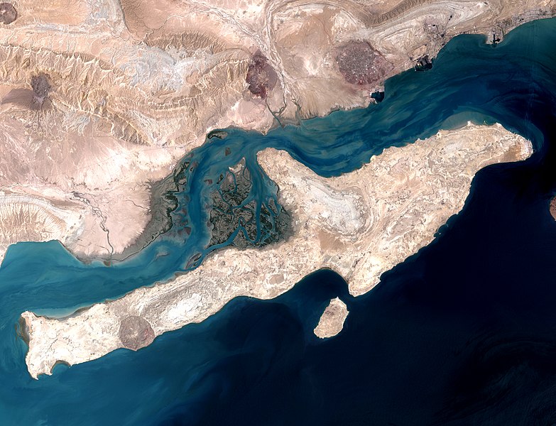
English: Qeshm Island in the Strait of Hormuz, Iran. This image is a combination of two images acquired by the Enhanced Thematic Mapper on NASA’s Landsat 7 satellite
فارسی: تصویر ماهوارهای از جزیرهٔ قشم در تنگهٔ هرمز |
| 날짜 | |
| 출처 | http://earthobservatory.nasa.gov/IOTD/view.php?id=7460 |
| 저자 | NASA image using data provided courtesy of the University of Maryland’s Global Land Cover Facility |
|
이 이미지는 2013년 5월 26일의 오늘의 이미지로 선정되었습니다. 이미지 설명은 다음과 같습니다. English: Qeshm Island in the Strait of Hormuz, Iran. This image is a combination of two images acquired by the Enhanced Thematic Mapper on NASA’s Landsat 7 satellite. 다른 언어들:
English: Qeshm Island in the Strait of Hormuz, Iran. This image is a combination of two images acquired by the Enhanced Thematic Mapper on NASA’s Landsat 7 satellite. Italiano: Isola di Qeshm nello stretto di Hormuz, Iran. Quest'immagine è la combinazione di due foto scattate dall'Enhanced Thematic Mapper Plus installto sul satellite Landsat 7. Magyar: Qeshm-sziget, Irán (A kép a Landsat 7 NASA műhold két képének kombinációjával készült.) Nederlands: Het eiland Qishm in de Straat van Hormuz, Iran. De foto is een combinatie van twee afbeeldingen door NASA’s Landsat 7-satelliet. Русский: Остров Кешм, вид из космоса. 中文: 伊朗霍尔木兹海峡格什姆岛。 |
라이선스
[편집]
| 이 파일은 NASA에서 제작하였으므로 퍼블릭 도메인입니다. NASA의 저작권 정책에 따르면 NASA의 자료는 명시하지 않는 이상 저작권의 보호를 받지 않습니다. (Template:PD-USGov, 또는 NASA 저작권 정책 문서, JPL 그림 사용 정책을 참고하세요.) | ||
 |
주의사항:
|
| 주석 | 이 이미지에는 주석이 있습니다: 공용에서 주석을 보기 |
파일 역사
날짜/시간 링크를 클릭하면 해당 시간의 파일을 볼 수 있습니다.
| 날짜/시간 | 섬네일 | 크기 | 사용자 | 설명 | |
|---|---|---|---|---|---|
| 현재 | 2013년 5월 28일 (화) 00:20 | | 3,850 × 2,950 (6.31 MB) | Lucassosa7 (토론 | 기여) | modificacion de curvas |
| 2009년 7월 27일 (월) 07:36 |  | 3,850 × 2,950 (2.7 MB) | Telim tor (토론 | 기여) | == Summary == {{Information |Description= {{en|Strait of Hormuz with Qeshm Island, Iran. This image is a combination of two images acquired by the Enhanced Thematic Mapper on NASA’s Landsat 7 satellite}} |Source=http://earthobservatory.nasa.gov/IOTD/vie |
이 파일을 덮어쓸 수 없습니다.
이 파일을 사용하는 문서
다음 문서 29개가 이 파일을 사용하고 있습니다:
- Featured Photographs in the Public Domain
- ایران
- User:Miya/sandbox/FP/2013/Galleries/Table
- User talk:Kasir
- Commons:Featured picture candidates/File:QeshmIsland NASA.jpg
- Commons:Featured picture candidates/Log/March 2013
- Commons:Featured pictures/Places/Satellite images
- Commons:Featured pictures/chronological/2013-A
- Commons:Picture of the Year/2013/Candidates
- Commons:Picture of the Year/2013/Galleries/Table
- Commons:Picture of the Year/2013/R1/Gallery/2013-A
- Commons:Picture of the Year/2013/R1/Gallery/ALL
- Commons:Picture of the Year/2013/R1/Gallery/Astronomy
- Commons:Picture of the Year/2013/R1/Gallery/M03
- Commons:Picture of the Year/2013/R1/Results/Candidates
- Commons:Picture of the Year/2013/R1/v/QeshmIsland NASA.jpg
- File:Released to Public Qeshm Island in Persian Gulf (NASA) (477880141).jpg (파일 넘겨주기)
- Template:Potd/2013-05
- Template:Potd/2013-05-26
- Template:Potd/2013-05-26 (en)
- Template:Potd/2013-05-26 (hu)
- Template:Potd/2013-05-26 (it)
- Template:Potd/2013-05-26 (nl)
- Template:Potd/2013-05-26 (ru)
- Template:Potd/2013-05-26 (zh-hans)
- Template:Potd/2013-05 (zh-hans)
- Template:Qeshm Island -year
- Category:2012 in Qeshm Island
- Category:Qeshm Island
_(477880141).jpg&redirect=no)
이 파일을 사용하고 있는 모든 위키의 문서 목록
다음 위키에서 이 파일을 사용하고 있습니다:
- ar.wikipedia.org에서 이 파일을 사용하고 있는 문서 목록
- arz.wikipedia.org에서 이 파일을 사용하고 있는 문서 목록
- az.wikipedia.org에서 이 파일을 사용하고 있는 문서 목록
- be-tarask.wikipedia.org에서 이 파일을 사용하고 있는 문서 목록
- be.wikipedia.org에서 이 파일을 사용하고 있는 문서 목록
- bn.wikipedia.org에서 이 파일을 사용하고 있는 문서 목록
- bn.wikibooks.org에서 이 파일을 사용하고 있는 문서 목록
- bs.wikipedia.org에서 이 파일을 사용하고 있는 문서 목록
- ca.wikipedia.org에서 이 파일을 사용하고 있는 문서 목록
- ceb.wikipedia.org에서 이 파일을 사용하고 있는 문서 목록
- crh.wikipedia.org에서 이 파일을 사용하고 있는 문서 목록
- cs.wikipedia.org에서 이 파일을 사용하고 있는 문서 목록
- cv.wikipedia.org에서 이 파일을 사용하고 있는 문서 목록
- de.wikipedia.org에서 이 파일을 사용하고 있는 문서 목록
- de.wikivoyage.org에서 이 파일을 사용하고 있는 문서 목록
- el.wikipedia.org에서 이 파일을 사용하고 있는 문서 목록
- en.wikipedia.org에서 이 파일을 사용하고 있는 문서 목록
- en.wikivoyage.org에서 이 파일을 사용하고 있는 문서 목록
- es.wikipedia.org에서 이 파일을 사용하고 있는 문서 목록
- Wikipedia:Imágenes destacadas/Lugares/Asia
- Qeshm
- Wikipedia:Recurso del día/801 - 900
- Áreas protegidas de Irán
- Wikipedia:Candidatos a recursos destacados/QeshmIsland NASA.jpg
- Wikipedia:Candidatos a recursos destacados/Febrero-2021
- Plantilla:RDD/855
- Wikipedia:Recurso del día/marzo de 2021
- Wikipedia:Recurso del día/febrero de 2023
- eu.wikipedia.org에서 이 파일을 사용하고 있는 문서 목록
- fa.wikipedia.org에서 이 파일을 사용하고 있는 문서 목록
이 파일의 더 많은 사용 내역을 봅니다.