File:ROC Matsu.png
跳至導覽
跳至搜尋

預覽大小:800 × 444 像素。 其他解析度:320 × 178 像素 | 640 × 355 像素 | 1,000 × 555 像素。
原始檔案 (1,000 × 555 像素,檔案大小:35 KB,MIME 類型:image/png)
說明
說明
添加單行說明來描述出檔案所代表的內容
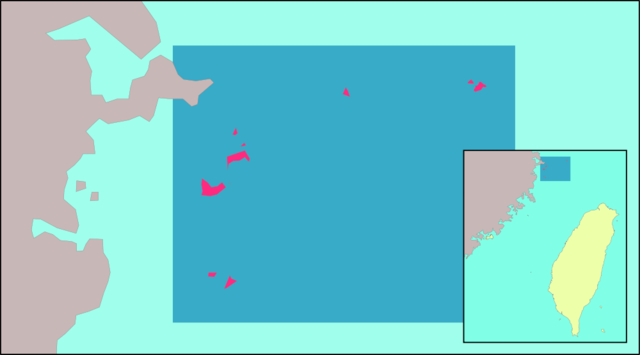
en: Location of Matsu Islands relative to Taiwan and mainland China. Made by uploader using Image:Taiwan Strait.png as base map. Borders were taken from zh:User:試吃那人's locator maps for Taiwanese counties. The faded box idea was borrowed from User:Nichalp's locator maps for Indian states.
zh: 馬祖列島相對於臺灣以及中國大陸的位置圖。上傳者以Image:Taiwan Strait.png為底圖自行製作。縣界來源為zh:User:試吃那人所繪製的臺灣縣市位置圖,淺色框襯托深色地區的創意來源為User:Nichalp所繪製的印度各邦位置圖。

|
已授權您依據自由軟體基金會發行的無固定段落、封面文字和封底文字GNU自由文件授權條款1.2版或任意後續版本,對本檔進行複製、傳播和/或修改。該協議的副本列在GNU自由文件授權條款中。 |
| 此檔案採用創用CC 姓名標示-相同方式分享 3.0 未在地化版本授權條款。 | ||
| ||
| 已新增授權條款標題至此檔案,作為GFDL授權更新的一部份。 |
檔案歷史
點選日期/時間以檢視該時間的檔案版本。
| 日期/時間 | 縮圖 | 尺寸 | 使用者 | 備註 | |
|---|---|---|---|---|---|
| 目前 | 2011年7月16日 (六) 09:47 | | 1,000 × 555(35 KB) | Energiya(留言 | 貢獻) | Zoom on the county |
| 2005年5月16日 (一) 20:14 |  | 362 × 425(11 KB) | Ran(留言 | 貢獻) | Location of the Matsu Islands relative to Taiwan and mainland China. Made by uploader using Image:Taiwan Strait.png as base map. The box idea was borrowed from User:Nichalp's locator maps for small Indian states. {{GFDL}} |
無法覆蓋此檔案。
檔案用途
下列頁面有用到此檔案:
全域檔案使用狀況
以下其他 wiki 使用了這個檔案:
- ca.wikipedia.org 的使用狀況
- cs.wikipedia.org 的使用狀況
- en.wikipedia.org 的使用狀況
- eu.wikipedia.org 的使用狀況
- ko.wikipedia.org 的使用狀況
- uk.wikipedia.org 的使用狀況
- vi.wikipedia.org 的使用狀況
- www.wikidata.org 的使用狀況
- zh-min-nan.wikipedia.org 的使用狀況
- zh-min-nan.wiktionary.org 的使用狀況
- zh.wikipedia.org 的使用狀況
- zh.wiktionary.org 的使用狀況