File:Race to Deir ezzor.svg
Vai alla navigazione
Vai alla ricerca

Dimensioni di questa anteprima PNG per questo file SVG: 800 × 500 pixel. Altre risoluzioni: 320 × 200 pixel | 640 × 400 pixel | 1 024 × 640 pixel | 1 280 × 800 pixel | 2 560 × 1 600 pixel | 1 440 × 900 pixel.
File originale (file in formato SVG, dimensioni nominali 1 440 × 900 pixel, dimensione del file: 7,49 MB)
Didascalie
Didascalie
Aggiungi una brevissima spiegazione di ciò che questo file rappresenta
Dettagli
[modifica]
| Descrizione |
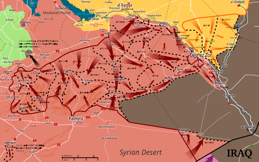
English: Situation of central Syria between July 14 - present. Map shows the advancements during the Central Syrian offensive. Made in Inkscape and influenced by many maps from creators: PetoLucem, A7_Mirza, SouthFront, and MrPenguin20.
Controlled by the Syrian Arab Republic
Controlled by the Syrian opposition
Controlled by the Syrian Democratic Forces
Controlled by the Islamic State of Iraq and the Levant (ISIL, ISIS, IS, Daesh)
Controlled by the Iraqi government |
| Data | |
| Fonte | Opera propria |
| Autore | Rr016 |
Licenza
[modifica]
Io, detentore del copyright su quest'opera, dichiaro di pubblicarla con la seguente licenza:
Questo file è disponibile in base alla licenza Creative Commons Attribuzione-Condividi allo stesso modo 4.0 Internazionale
- Tu sei libero:
- di condividere – di copiare, distribuire e trasmettere quest'opera
- di modificare – di adattare l'opera
- Alle seguenti condizioni:
- attribuzione – Devi fornire i crediti appropriati, un collegamento alla licenza e indicare se sono state apportate modifiche. Puoi farlo in qualsiasi modo ragionevole, ma non in alcun modo che suggerisca che il licenziante approvi te o il tuo uso.
- condividi allo stesso modo – Se remixi, trasformi o sviluppi il materiale, devi distribuire i tuoi contributi in base alla stessa licenza o compatibile all'originale.
Cronologia del file
Fare clic su un gruppo data/ora per vedere il file come si presentava nel momento indicato.
| Data/Ora | Miniatura | Dimensioni | Utente | Commento | |
|---|---|---|---|---|---|
| attuale | 17:11, 22 ott 2017 | | 1 440 × 900 (7,49 MB) | Rr016 (discussione | contributi) | Added recapture of Qaryatayn and other details on the map as per LightandDark2000's request. |
| 19:21, 21 ott 2017 |  | 1 440 × 900 (7,48 MB) | Rr016 (discussione | contributi) | Central Syria Campaign is over. Map is finished. | |
| 12:37, 10 ott 2017 |  | 1 440 × 900 (7,48 MB) | Rr016 (discussione | contributi) | Strange update: ISIS is now attacking HTS positions north of al San? Not sure how they got there. | |
| 20:42, 8 ott 2017 |  | 1 440 × 900 (7,47 MB) | Rr016 (discussione | contributi) | Small update: ISIS east Hama pocket completely taken by SAA, SDF are advancing along Euphrates. | |
| 20:36, 4 ott 2017 |  | 1 440 × 900 (7,47 MB) | Rr016 (discussione | contributi) | Update: east Hama pocket shrinking, SAA advancing towards Mayadin, SDF captures al Suwar, Jafra oil fields, and are advancing along Euphrates. | |
| 18:58, 23 set 2017 |  | 1 440 × 900 (7,46 MB) | Rr016 (discussione | contributi) | Updates and fixes: SAA clears Maadan Euphrates area and crossed the river. SDF is advancing east towards oil wells. Removed some arrows and lines - too much. Also Iraqi forces are moving along their border. | |
| 17:51, 10 set 2017 |  | 1 440 × 900 (7,46 MB) | Rr016 (discussione | contributi) | Update and fixes: SDF has reached Deir ez Zor industrial zone, SAA secured Shoula-Deir road. Removed some dashed lines, there's a bit too much on this map. | |
| 12:55, 10 set 2017 |  | 1 440 × 900 (7,46 MB) | Rr016 (discussione | contributi) | Big update: SAA lifts Deir airbase siege and SDF are pushing south towards Deir ez Zor. | |
| 19:15, 5 set 2017 |  | 1 440 × 900 (7,44 MB) | Rr016 (discussione | contributi) | Siege of Deir ez Zor has been lifted. Uqayribat captured by SAA. | |
| 16:46, 1 set 2017 |  | 1 440 × 900 (7,43 MB) | Rr016 (discussione | contributi) | Update - Uqayribat pocket is being taken by SAA. SAA advance east of al Sukhnah reaching Deir ez Zor governorate. |
Impossibile sovrascrivere questo file.
Utilizzo del file
Le seguenti 5 pagine usano questo file:
Utilizzo globale del file
Anche i seguenti wiki usano questo file:
- Usato nelle seguenti pagine di ar.wikipedia.org:
- Usato nelle seguenti pagine di be.wikipedia.org:
- Usato nelle seguenti pagine di en.wikipedia.org:
- Usato nelle seguenti pagine di es.wikipedia.org:
- Usato nelle seguenti pagine di fa.wikipedia.org:
- Usato nelle seguenti pagine di fr.wikipedia.org:
- Usato nelle seguenti pagine di fr.wikinews.org:
- Usato nelle seguenti pagine di it.wikipedia.org:
- Usato nelle seguenti pagine di pl.wikipedia.org:
- Usato nelle seguenti pagine di pt.wikipedia.org:
- Usato nelle seguenti pagine di ru.wikipedia.org:
- Usato nelle seguenti pagine di www.wikidata.org:
- Usato nelle seguenti pagine di zh.wikipedia.org: