File:Rb-map.png
Rb-map.png (328 × 352 פיקסלים, גודל הקובץ: 13 ק"ב, סוג MIME: image/png)
כיתובים
כיתובים
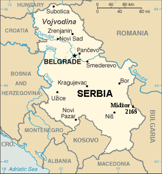
| תיאור | Map of the Republic of Serbia (FIPS 10 country code standard: RB) | |||
| תאריך יצירה | ||||
| מקור | The World Factbook (published by CIA in 2008). | |||
| יוצר | Central Intelligence Agency of the Government of the United States of America | |||
| אישורים והיתרים (שימוש חוזר בקובץ זה) |
|
|||
| גרסאות אחרות | Recommend that Image:Sr-map.png should be deleted and Image:Serbia-CIA WFB Map.png should be spared to show how the map looked before 2008. |
תקציר
[עריכה]
Map of Serbia from The World Factbook archive copy at the Wayback Machine (published by CIA in 2008).
This map is updated with current events; independence of Kosovo and certain faults like BUL. is replaced with BULGARIA. The name of the country is in bold font, like the name of the Autonomous Province of Vojvodina (Northern Serbian province). Also the highest mountain in Serbia (Central Serbia region) is marked at the border with Bulgaria with the name of that peak - Midžor - and added the height in meters.
The name of the file
[עריכה]
The National Geospatial-Intelligence Agency maintains the FIPS 10 country code standard that US Government use.
On 2006-07-11 the following changes have been made:
DELETE the following geopolitical entities and codes:
- YI SERBIA AND MONTENEGRO
- YI01 Crna Gora (Montenegro)
- YI02 Srbija (Serbia)
ADD the following geopolitical entity and code:
- MJ MONTENEGRO
ADD the following geopolitical entity and code:
- RB SERBIA
The notice was issued by:
Randall E. Flynn
Geographer
National Geospatial-Intelligence Agency
GEOnet Names Server at this web-site.
Recommend that Image:Sr-map.png should be deleted and Image:Serbia-CIA WFB Map.png should be spared to show how the map looked before 2008.
רישיון
[עריכה]
This image is in the public domain because it contains materials that originally came from the United States Central Intelligence Agency's World Factbook.
|
 |
For enhancements
[עריכה]
| ברצוני, בעלי זכויות היוצרים על יצירה זו, לשחרר יצירה זו לנחלת הכלל. זה תקף בכל העולם. יש מדינות שבהן הדבר אינו אפשרי על פי חוק, אם כך: אני מעניק לכל אחד את הזכות להשתמש בעבודה זו לכל מטרה שהיא, ללא תנאים כלשהם, אלא אם כן תנאים כאלה נדרשים על פי חוק. |
היסטוריית הקובץ
ניתן ללחוץ על תאריך/שעה כדי לראות את הקובץ כפי שנראה באותו זמן.
| תאריך/שעה | תמונה ממוזערת | ממדים | משתמש | הערה | |
|---|---|---|---|---|---|
| נוכחית | 21:22, 15 בינואר 2014 | | 352 × 328 (13 ק"ב) | Denniss (שיחה | תרומות) | Reverted to version as of 19:30, 14 February 2008 |
| 21:13, 15 בינואר 2014 |  | 352 × 328 (36 ק"ב) | Ivan VA (שיחה | תרומות) | updating borders | |
| 21:12, 15 בינואר 2014 |  | 352 × 328 (36 ק"ב) | Ivan VA (שיחה | תרומות) | vandalizm | |
| 22:29, 2 בינואר 2014 |  | 352 × 328 (13 ק"ב) | No More Cats (שיחה | תרומות) | oops, I got the wrong version | |
| 16:11, 2 בינואר 2014 |  | 352 × 328 (13 ק"ב) | No More Cats (שיחה | תרומות) | Reverted to version as of 12:25, 28 February 2011 - original CIA map | |
| 13:53, 8 באוגוסט 2013 |  | 352 × 328 (36 ק"ב) | Pokrajac (שיחה | תרומות) | Reverted to version as of 21:00, 11 February 2011 | |
| 12:25, 28 בפברואר 2011 |  | 352 × 328 (13 ק"ב) | IJA (שיחה | תרומות) | Reverted to version as of 19:30, 14 February 2008 | |
| 21:00, 11 בפברואר 2011 |  | 352 × 328 (36 ק"ב) | Pokrajac (שיחה | תרומות) | {{Information |Description=Map of the Republic of Serbia (FIPS 10 country code standard: RB) |Source=[https://www.cia.gov/library/publications/the-world-factbook/geos/rb.html The World Factbook] (published by CIA in 2008). |Date=2008-02-28 |Author=Central | |
| 19:30, 14 בפברואר 2008 |  | 352 × 328 (13 ק"ב) | Imbris~commonswiki (שיחה | תרומות) | {{Information |Description=Map of the Republic of Serbia (FIPS 10 country code standard: RB) |Source=[https://www.cia.gov/library/publications/the-world-factbook/geos/rb.html The World Factbook] (published by CIA in 2008). |Date=2008-06-15 |Author=Central |
אין באפשרותך לדרוס את הקובץ הזה.
שימוש בקובץ
הדף הבא משתמש בקובץ הזה:
שימוש גלובלי בקובץ
אתרי הוויקי השונים הבאים משתמשים בקובץ זה:
- שימוש באתר de.wikipedia.org
- שימוש באתר eo.wikipedia.org
- שימוש באתר he.wikipedia.org
- שימוש באתר nl.wiktionary.org
- שימוש באתר to.wikipedia.org