File:Regional Internet Registries world map.svg
Jump to navigation
Jump to search

ഈ SVG പ്രമാണത്തിന്റെ PNG പ്രിവ്യൂവിന്റെ വലിപ്പം: 800 × 353 പിക്സലുകൾ. മറ്റ് റെസലൂഷനുകൾ: 320 × 141 പിക്സലുകൾ | 640 × 283 പിക്സലുകൾ | 1,024 × 452 പിക്സലുകൾ | 1,280 × 565 പിക്സലുകൾ | 2,560 × 1,130 പിക്സലുകൾ | 940 × 415 പിക്സലുകൾ.
പൂർണ്ണ വലിപ്പം (എസ്.വി.ജി. പ്രമാണം, നാമമാത്രമായ 940 × 415 പിക്സലുകൾ, പ്രമാണത്തിന്റെ വലിപ്പം: 1.48 എം.ബി.)
തലവാചകം
തലവാചകങ്ങൾ
ഈ പ്രമാണം എന്തിനെ പ്രതിനിധീകരിക്കുന്നുവെന്ന ഒറ്റവരി വിശദീകരണം ചേർക്കുക
ചുരുക്കം[തിരുത്തുക]
| വിവരണം |
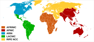
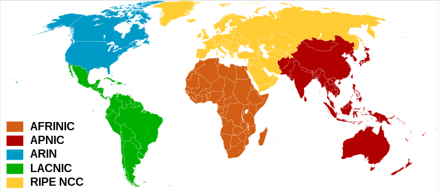
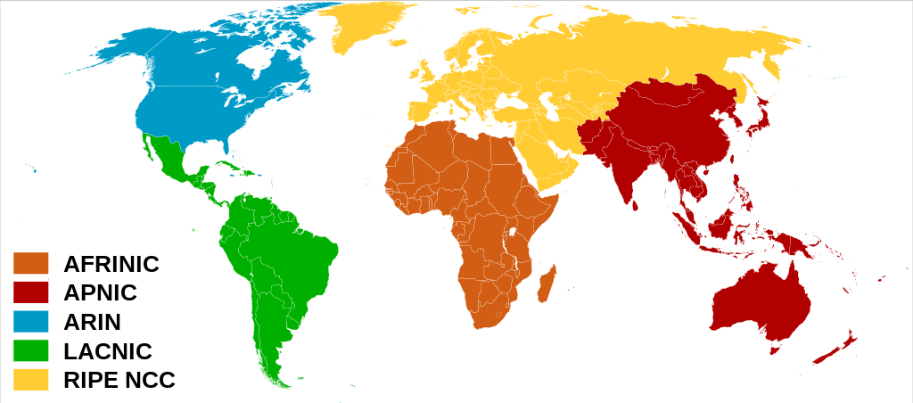
العربية: خريطة العالم بحسب سجلات الإنترنت الإقليمية.
English: Regional Internet Registries world map.
Español: Mapa de Registros Regionales de Internet.
Français : Carte du monde des organisations de registre Internet régional. |
| തീയതി | (UTC) |
| സ്രോതസ്സ് | |
| സ്രഷ്ടാവ് | |
| മറ്റു പതിപ്പുകൾ |
 |
അനുമതി[തിരുത്തുക]
ഈ പ്രമാണത്തിന് അനുമതി നൽകപ്പെട്ടിരിക്കുന്നത് ക്രിയേറ്റീവ് കോമൺസ് ആട്രിബ്യൂഷൻ-ഷെയർ എലൈക് 3.0 അൺപോർട്ടഡ് അനുവാദപത്ര പ്രകാരമാണ്.
- താങ്കൾക്കുള്ള സ്വാതന്ത്ര്യങ്ങൾ:
- പങ്ക് വെയ്ക്കൽ – കൃതി പകർത്താനും, വിതരണം ചെയ്യാനും, പ്രസരിപ്പിക്കാനും
- പുനഃമിശ്രണം ചെയ്യൽ – കൃതി അനുയുക്തമാക്കാൻ
- താഴെ പറയുന്ന ഉപാധികൾ പാലിക്കുക:
- കടപ്പാട് – രചയിതാവോ അനുമതിയുള്ളയാളോ വ്യക്തമാക്കിയിട്ടുള്ള വിധത്തിൽ കൃതിയ്ക്കുള്ള കടപ്പാട് താങ്കൾ നൽകിയിരിക്കണം. താങ്കൾക്കിത് ഏത് വിധത്തിൽ വേണമെങ്കിലും ചെയ്യാവുന്നതാണ്, പക്ഷേ അത് അവർ താങ്കളേയോ താങ്കളുടെ ഉപയോഗത്തേയോ അടിച്ചേൽപ്പിച്ചതു പോലെയാവരുത്.
- ഇതു പോലെ പങ്ക് വെയ്ക്കുക – ഈ സൃഷ്ടിയെ പുനഃമിശ്രണം ചെയ്തോ രൂപാന്തരപ്പെടുത്തിയോ അടിസ്ഥാനപ്പെടുത്തിയോ ഉണ്ടാക്കുന്നവ; താങ്കളുടെ സംഭാവനയടക്കമുള്ള സൃഷ്ടി യഥാർത്ഥ സൃഷ്ടിയുടെ അതേ അല്ലെങ്കിൽ അനുരൂപമായ ഉപയോഗാനുമതിയിൽ മാത്രമേ താങ്കൾ വിതരണം ചെയ്യാവൂ.
യഥാർത്ഥ അപ്ലോഡ് രേഖ[തിരുത്തുക]
This image is a derivative work of the following images:
- File:Rir.gif licensed with Cc-by-sa-2.5, Cc-by-sa-2.5/en
- 2006-04-02T01:24:59Z Dork 300x163 (3093 Bytes) Regional Internet Registries (containing AFRINIC)
- File:BlankMap-World6,_compact.svg licensed with PD-self, PD-self/en
- 2008-12-02T18:21:18Z Lokal Profil 940x415 (1518276 Bytes) Reverted to version as of 14:51, 13 June 2008, new image has non of the complexity (i.e. colouring abilities etc.) of the old
- 2008-12-02T17:29:39Z Harbin 1326x601 (176022 Bytes)
- 2008-12-02T17:26:08Z Harbin 1425x625 (189017 Bytes)
- 2008-06-13T14:51:25Z Lokal Profil 940x415 (1518276 Bytes) Syncing with [[:Image:BlankMap-World6.svg]] version (01:30, March 29, 2008). Sadly enough the validator does not seem to like rdf element of the metadata although it should work acording to http://www.w3schools.com/rdf/rdf_ma
- 2008-02-08T20:55:35Z CarolSpears 940x415 (1528750 Bytes) validated, maybe
- 2007-12-14T19:51:17Z Lokal Profil 940x415 (1529675 Bytes) Readded an ocean object but this one is square instead of the original elliptic one
- 2007-12-14T19:19:56Z Lokal Profil 940x415 (1529845 Bytes) {{Information |Description=Detailed SVG map with grouping enabled to connect all non-contiguous parts of a country's territory for easy colouring. Smaller countries can also be represented by larger circles to show their data
ഡെറിവേറ്റീവ്എഫ്എക്സ് ഉപയോഗിച്ചാണ് അപ്ലോഡ് ചെയ്തത്
പ്രമാണ നാൾവഴി
ഏതെങ്കിലും തീയതി/സമയ കണ്ണിയിൽ ഞെക്കിയാൽ പ്രസ്തുതസമയത്ത് ഈ പ്രമാണം എങ്ങനെയായിരുന്നു എന്നു കാണാം.
| തീയതി/സമയം | ലഘുചിത്രം | അളവുകൾ | ഉപയോക്താവ് | അഭിപ്രായം | |
|---|---|---|---|---|---|
| നിലവിലുള്ളത് | 08:57, 8 ഫെബ്രുവരി 2020 | | 940 × 415 (1.48 എം.ബി.) | Rauisuchian (സംവാദം | സംഭാവനകൾ) | Corrected name to AFRINIC, all capitalized |
| 08:18, 8 ഫെബ്രുവരി 2020 |  | 940 × 415 (1.48 എം.ബി.) | Rauisuchian (സംവാദം | സംഭാവനകൾ) | Change the ARIN and AFRINIC fill colors to those on their logos/websites. | |
| 19:59, 28 ജൂൺ 2011 |  | 940 × 415 (1.48 എം.ബി.) | DOSGuy (സംവാദം | സംഭാവനകൾ) | Moved Dominica, Jamaica, Puerto Rico, Saint Lucia, Saint Vincent and the Grenadines from LACNIC to ARIN. Moved a number of Caribbean islands from RIPE to ARIN. Moved Fiji from RIPE to APNIC. Moved Falkland Islands from RIPE to LACNIC. | |
| 14:59, 17 ഒക്ടോബർ 2010 |  | 940 × 415 (1.48 എം.ബി.) | Ben g (സംവാദം | സംഭാവനകൾ) | The less dominant texts were better | |
| 16:12, 28 ജനുവരി 2009 |  | 940 × 415 (1.48 എം.ബി.) | Sémhur (സംവാദം | സംഭാവനകൾ) | Bigger texts | |
| 12:12, 28 ജനുവരി 2009 |  | 940 × 415 (1.48 എം.ബി.) | Sémhur (സംവാദം | സംഭാവനകൾ) | {{Information |Description= {{en|Regional Internet Registries world map.}} {{fr|Carte du monde des organisations deregistre Internet régional.}} |Source= *File:Rir.gif *File:BlankMap-World6,_compact.svg |Da |
ഈ പ്രമാണത്തിനു മുകളിൽ മറ്റൊരു പ്രമാണം ചേർക്കാൻ താങ്കൾക്ക് കഴിയില്ല.
പ്രമാണത്തിന്റെ ഉപയോഗം
താഴെ കാണുന്ന 3 താളുകളിൽ ഈ ചിത്രം ഉപയോഗിക്കുന്നു:
പ്രമാണത്തിന്റെ ആഗോള ഉപയോഗം
താഴെ കൊടുത്തിരിക്കുന്ന മറ്റ് വിക്കികൾ ഈ പ്രമാണം ഉപയോഗിക്കുന്നു:
- ar.wikipedia.org സംരംഭത്തിലെ ഉപയോഗം
- az.wikipedia.org സംരംഭത്തിലെ ഉപയോഗം
- be.wikipedia.org സംരംഭത്തിലെ ഉപയോഗം
- bn.wikipedia.org സംരംഭത്തിലെ ഉപയോഗം
- ca.wikipedia.org സംരംഭത്തിലെ ഉപയോഗം
- ckb.wikipedia.org സംരംഭത്തിലെ ഉപയോഗം
- de.wikipedia.org സംരംഭത്തിലെ ഉപയോഗം
- en.wikipedia.org സംരംഭത്തിലെ ഉപയോഗം
- eo.wikipedia.org സംരംഭത്തിലെ ഉപയോഗം
- es.wikipedia.org സംരംഭത്തിലെ ഉപയോഗം
- fr.wikipedia.org സംരംഭത്തിലെ ഉപയോഗം
- he.wikipedia.org സംരംഭത്തിലെ ഉപയോഗം
- hu.wikipedia.org സംരംഭത്തിലെ ഉപയോഗം
- ilo.wikipedia.org സംരംഭത്തിലെ ഉപയോഗം
- it.wikipedia.org സംരംഭത്തിലെ ഉപയോഗം
- ja.wikipedia.org സംരംഭത്തിലെ ഉപയോഗം
- ko.wikipedia.org സംരംഭത്തിലെ ഉപയോഗം
- la.wikipedia.org സംരംഭത്തിലെ ഉപയോഗം
- ml.wikipedia.org സംരംഭത്തിലെ ഉപയോഗം
- ms.wikipedia.org സംരംഭത്തിലെ ഉപയോഗം
- nl.wikipedia.org സംരംഭത്തിലെ ഉപയോഗം
- no.wikipedia.org സംരംഭത്തിലെ ഉപയോഗം
- pl.wikipedia.org സംരംഭത്തിലെ ഉപയോഗം
- pt.wikipedia.org സംരംഭത്തിലെ ഉപയോഗം
- ru.wikipedia.org സംരംഭത്തിലെ ഉപയോഗം
- sr.wikipedia.org സംരംഭത്തിലെ ഉപയോഗം
ഈ പ്രമാണത്തിന്റെ കൂടുതൽ ആഗോള ഉപയോഗം കാണുക.