File:Rospuda Valley, Poland.jpg
Pereiti į navigaciją
Jump to search

Šios peržiūros dydis: 800 × 533 taškų. Kitos 5 rezoliucijos: 320 × 213 taškų | 640 × 427 taškų | 1 024 × 683 taškų | 1 280 × 853 taškų | 3 000 × 2 000 taškų.
Pradinė rinkmena (3 000 × 2 000 taškų, rinkmenos dydis: 3,25 MiB, MIME tipas: image/jpeg)
Captions
Captions
Add a one-line explanation of what this file represents
Aprašymas[keisti]
| Aprašymas |
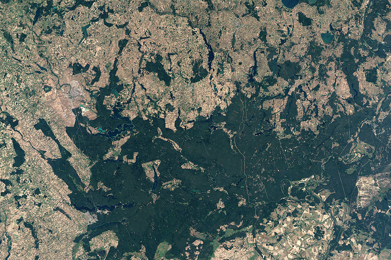
English: NASA’s Landsat 7 satellite captured this image of Rospuda Valley. This true-color image shows a patchwork of peat bog and agricultural fields. In contrast to the nearly uniform deep-green wetlands, the fields appear as close-knit rectangles of varied shades of green and beige. Rospuda River meanders between cultivated fields in the northwest and wetland territory in the southeast, connecting with Lake Necko. Numerous other lakes and ponds appear north and east of Lake Necko, some of them overlapping agricultural areas. |
| Data | |
| Šaltinis | NASA Earth Observatory |
| Autorius | Jesse Allen |
NASA image created by Jesse Allen, using Landsat data provided by the United States Geological Survey.
Licencija[keisti]
| Šis failas licencijuojamas viešajam naudojimui, nes jis buvo sukurtas NASA. NASA autorinių teisių taisyklės nurodo, kad „NASA medžiaga nėra saugoma autorinių teisių, išskyrus pažymėtą“ (NASA autorių teisių taisylės arba JPL paveikslėlių naudojimo tvarka). | ||
 |
Įspėjimai:
|
Rinkmenos istorija
Paspauskite ant datos/laiko, kad pamatytumėte rinkmeną tokią, kokia ji buvo tuo metu.
| Data/Laikas | Miniatiūra | Matmenys | Naudotojas | Paaiškinimas | |
|---|---|---|---|---|---|
| dabartinis | 13:34, 19 balandžio 2009 | | 3 000 × 2 000 (3,25 MiB) | Originalwana (aptarimas | indėlis) | {{Information |Description={{en|1=NASA’s Landsat 7 satellite captured this image of Rospuda Valley. This true-color image shows a patchwork of peat bog and agricultural fields. In contrast to the nearly uniform deep-green wetlands, the fields appear as |
Jūs negalite perrašyti šios rinkmenos.
Rinkmenos naudojimas
Rinkmena nėra naudojama jokiame puslapyje.
Visuotinis rinkmenos naudojimas
Ši rinkmena naudojama šiose viki svetainėse:
- Naudojama en.wikipedia.org
- Naudojama ka.wikipedia.org
- Naudojama lt.wikipedia.org
- Naudojama ru.wikipedia.org
- Naudojama uk.wikipedia.org
- Naudojama zh.wikipedia.org