File:Second Severn Crossing pano 1.jpg
둘러보기로 이동
검색으로 이동
미리 보기 크기: 798 × 138 픽셀 다른 해상도: 320 × 55 픽셀 | 640 × 111 픽셀 | 1,024 × 177 픽셀 | 1,280 × 221 픽셀 | 6,880 × 1,190 픽셀
원본 파일 (6,880 × 1,190 픽셀, 파일 크기: 1.77 MB, MIME 종류: image/jpeg)
캡션
설명
이 파일이 나타내는 바에 대한 한 줄 설명을 추가합니다
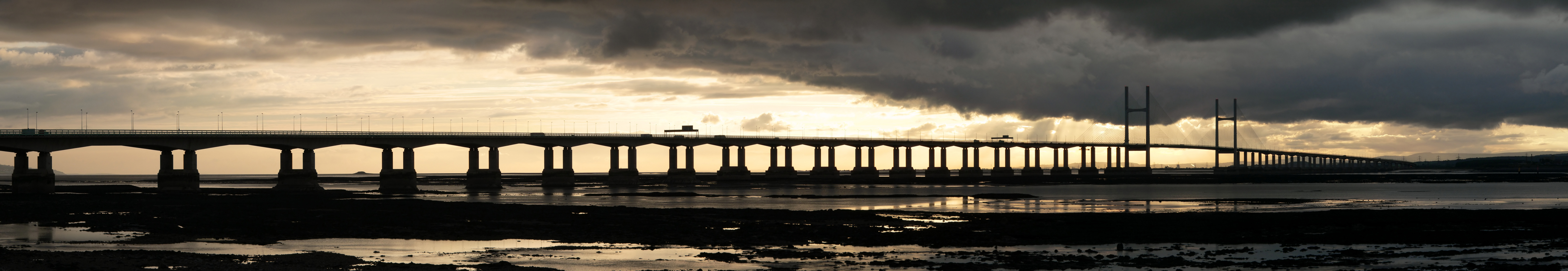
이 이미지는 2009년 10월 30일의 오늘의 이미지로 선정되었습니다. 이미지 설명은 다음과 같습니다. English: The Second Severn Crossing carrying the M4 motorway across the River Severn between Severn Beach near Avonmouth in south west England and Caldicot in south Wales. 다른 언어들:
Bahasa Indonesia: Second Severn Crossing (Jembatan Severn Kedua) yang dilintasi jalan raya M4 melalui Sungai Severn antara Pantai Severn di dekat Avonmouth di barat daya Inggris dan Caldicot di selatan Wales. Bosanski: „Second Severn Crossing“ nosi autoput „M-4“ preko rijeke Severn između Severn Beach-a pored Avonmouth-a u jugozapadnoj Engleskoj i Caldicot-a u južnom Velsu. Čeština: Most Second Severn Crossing, po kterém britská dálnice M4 překonává řeku Severn mezi anglickým Avonmouthem a velšským Caldicotem Dansk: Motorvejsbroen, som fører M4-motorvejen over floden Severn mellem Severn Beach nær Avonmouth i det sydvestlige England og Caldicot i det sydlige Wales. English: The Second Severn Crossing carrying the M4 motorway across the River Severn between Severn Beach near Avonmouth in south west England and Caldicot in south Wales. Español: Segundo puente sobre el río Severn, por el que transcurre la autovía M4 entre Severn Beach (Inglaterra) y Caldicot (País de Gales). Français : Le Second pont sur la rivière Severn, portant l'autoroute M4 entre Severn Beach (Angleterre) et Caldicot (Pays de Galles), vu du coté anglais. Italiano: Il ponte autostradale sul Severn, che collega Severn Beach (in Inghilterra) a Caldicot (in Galles), visto dalla sponda inglese. Magyar: Az angliai Severn-folyót átszelő M4-es autópálya hídja (Avonmouth, délnyugat Anglia és Caldicot, dél Wales között) Nederlands: De Second Severn Crossing, een brug die de Britse autosnelweg M4 over de Severn (de langste rivier van het Verenigd Koninkrijk) draagt, tussen het Engelse dorp Severn Beach (nabij Bristol) en het Welshe stadje Caldicot. Português: Segunda Ponte do Severn (substituta da antiga Ponte do Severn) que cruza o Rio Severn no Reino Unido. Македонски: Вториот премин на реката Северн со автопатот M4 помеѓу југозападна Англија и јужен Велс. বাংলা : সেভেন সেভার্ন ক্রসিংয়ের ওপর অবস্থিত এম৪ সড়কপথ। সেভার্ন নদীর দুই প্রান্ত; পশ্চিম ইংল্যান্ডের অ্যাভনমাউথ ও দক্ষিণ ওয়েলসের ক্যালডিকট অঞ্চলকে যুক্ত করে এর অবস্থান। |
파일 설명
[편집]| 설명 |
English: The Second Severn Crossing carrying the M4 motorway across the River Severn between Severn Beach near Avonmouth in south west England and Caldicot in south Wales. This view, composed from 16 separate images, is looking west from the English side. The bridge has a total span of 5.1 km and includes a cable-stayed section called the Shoots Bridge which spans the shipping channel between the two towers. The River Severn has a vast tidal range - the point from which this photograph was taken would be covered at high tide.
Français : Le Second pont sur la rivière Severn, portant l'autoroute M4 entre Severn Beach (Angleterre) et Caldicot (Pays de Galles), vu du coté anglais. Le pont a une portée totale de 5,1 km et possède une section nommée Shoots Bridge par dessus le chenal navigable. La rivière Severn à une très forte marée. Le point d'où la photo a été prise est couvert par les hautes eaux. Cette vue panoramique est constituée à partir de 16 images séparées. |
| 날짜 | |
| 출처 | 자작 |
| 저자 | Yummifruitbat |
| 저작권 (이 파일을 인용하기) |
CC-BY-SA 2.5 |
| 다른 버전 | 이 파일은 다음으로 파생됨: Severn Crossing banner.jpg |
| 카메라 위치 | | 이 지역의 다른 사진을 보기: OpenStreetMap |
|---|
|

라이선스
[편집]
나는 아래 작품의 저작권자로서, 이 저작물을 다음과 같은 라이선스로 배포합니다:
이 파일은 크리에이티브 커먼즈 저작자표시-동일조건변경허락 2.5 일반 라이선스로 배포됩니다.
- 이용자는 다음의 권리를 갖습니다:
- 공유 및 이용 – 저작물의 복제, 배포, 전시, 공연 및 공중송신
- 재창작 – 저작물의 개작, 수정, 2차적저작물 창작
- 다음과 같은 조건을 따라야 합니다:
- 저작자표시 – 적절한 저작자 표시를 제공하고, 라이센스에 대한 링크를 제공하고, 변경사항이 있는지를 표시해야 합니다. 당신은 합리적인 방식으로 표시할 수 있지만, 어떤 방식으로든 사용권 허가자가 당신 또는 당신의 사용을 지지하는 방식으로 표시할 수 없습니다.
- 동일조건변경허락 – 만약 당신이 이 저작물을 리믹스 또는 변형하거나 이 저작물을 기반으로 제작하는 경우, 당신은 당신의 기여물을 원저작물과 동일하거나 호환 가능한 라이선스에 따라 배포하여야 합니다.
파일 역사
날짜/시간 링크를 클릭하면 해당 시간의 파일을 볼 수 있습니다.
| 날짜/시간 | 섬네일 | 크기 | 사용자 | 설명 | |
|---|---|---|---|---|---|
| 현재 | 2006년 9월 14일 (목) 22:40 | 6,880 × 1,190 (1.77 MB) | Yummifruitbat (토론 | 기여) | {{Information |Description=The Second Severn Crossing carrying the M4 motorway across the River Severn between Severn Beach near Avonmouth in south west [ |
이 파일을 덮어쓸 수 없습니다.
이 파일을 사용하는 문서
다음 문서 39개가 이 파일을 사용하고 있습니다:
- River
- User:Dschwen/FP2006
- User:Yummifruitbat
- Commons:Featured picture candidates/Image:Second Severn Crossing pano 1.jpg
- Commons:Featured picture candidates/Log/October 2006
- Commons:Featured pictures/Places/Architecture/Bridges
- Commons:Featured pictures/Places/Panoramas
- Commons:Featured pictures/chronological/2006-B
- Commons:Picture of the Year/2006/gallery
- Commons:Picture of the Year/2006/gallery0
- Commons:Picture of the Year/2006/gallery large
- Commons:Potd/2009-10 (da)
- Commons:Potd/2009-10 (de)
- Commons:Potd/2009-10 (eo)
- Commons:Potd/2009-10 (nl)
- Commons:Potd/2009-10 (pt)
- Commons:Potd/2009-10 (tr)
- Commons talk:Featured picture candidates/Archive candidate list
- File:Severn Crossing banner.jpg
- Template:Potd/2009-10
- Template:Potd/2009-10-30
- Template:Potd/2009-10-30 (bn)
- Template:Potd/2009-10-30 (bs)
- Template:Potd/2009-10-30 (cs)
- Template:Potd/2009-10-30 (da)
- Template:Potd/2009-10-30 (en)
- Template:Potd/2009-10-30 (es)
- Template:Potd/2009-10-30 (fr)
- Template:Potd/2009-10-30 (hu)
- Template:Potd/2009-10-30 (id)
- Template:Potd/2009-10-30 (it)
- Template:Potd/2009-10-30 (mk)
- Template:Potd/2009-10-30 (nl)
- Template:Potd/2009-10-30 (pam)
- Template:Potd/2009-10-30 (pt)
- Template:Potd/2009-10-30 (ru)
- Template:Potd/2009-10-30 (zh-hans)
- Template:Potd/2009-10-30 (zh-hant)
- Template:Potd/2009-10 (zh-hans)
이 파일을 사용하고 있는 모든 위키의 문서 목록
다음 위키에서 이 파일을 사용하고 있습니다:
- bn.wikipedia.org에서 이 파일을 사용하고 있는 문서 목록
- crh.wikipedia.org에서 이 파일을 사용하고 있는 문서 목록
- cv.wikipedia.org에서 이 파일을 사용하고 있는 문서 목록
- da.wikipedia.org에서 이 파일을 사용하고 있는 문서 목록
- de.wikipedia.org에서 이 파일을 사용하고 있는 문서 목록
- en.wikipedia.org에서 이 파일을 사용하고 있는 문서 목록
- en.wikibooks.org에서 이 파일을 사용하고 있는 문서 목록
- fr.wikipedia.org에서 이 파일을 사용하고 있는 문서 목록
- hu.wikipedia.org에서 이 파일을 사용하고 있는 문서 목록
- id.wikipedia.org에서 이 파일을 사용하고 있는 문서 목록
- ko.wikipedia.org에서 이 파일을 사용하고 있는 문서 목록
- krc.wikipedia.org에서 이 파일을 사용하고 있는 문서 목록
- lbe.wikipedia.org에서 이 파일을 사용하고 있는 문서 목록
- mg.wikipedia.org에서 이 파일을 사용하고 있는 문서 목록
- mk.wikipedia.org에서 이 파일을 사용하고 있는 문서 목록
- no.wikipedia.org에서 이 파일을 사용하고 있는 문서 목록
- os.wikipedia.org에서 이 파일을 사용하고 있는 문서 목록
- pam.wikipedia.org에서 이 파일을 사용하고 있는 문서 목록
- pl.wikipedia.org에서 이 파일을 사용하고 있는 문서 목록
- pt.wikipedia.org에서 이 파일을 사용하고 있는 문서 목록
- ru.wikipedia.org에서 이 파일을 사용하고 있는 문서 목록
- ru.wikinews.org에서 이 파일을 사용하고 있는 문서 목록
- sah.wikipedia.org에서 이 파일을 사용하고 있는 문서 목록
- uk.wikipedia.org에서 이 파일을 사용하고 있는 문서 목록
- vi.wikipedia.org에서 이 파일을 사용하고 있는 문서 목록
- xal.wikipedia.org에서 이 파일을 사용하고 있는 문서 목록
- zh.wikipedia.org에서 이 파일을 사용하고 있는 문서 목록