File:Serbia-WW1-4.jpg
קפיצה לניווט
קפיצה לחיפוש
גודל התצוגה המקדימה הזאת: 799 × 271 פיקסלים. רזולוציות אחרות: 320 × 109 פיקסלים | 1,023 × 347 פיקסלים.
לקובץ המקורי (1,023 × 347 פיקסלים, גודל הקובץ: 99 ק"ב, סוג MIME: image/jpeg)
כיתובים
כיתובים
נא להוסיף משפט שמסביר מה הקובץ מייצג

|
This map has been uploaded by Electionworld from en.wikipedia.org to enable the |
תקציר[עריכה]
| תיאור |
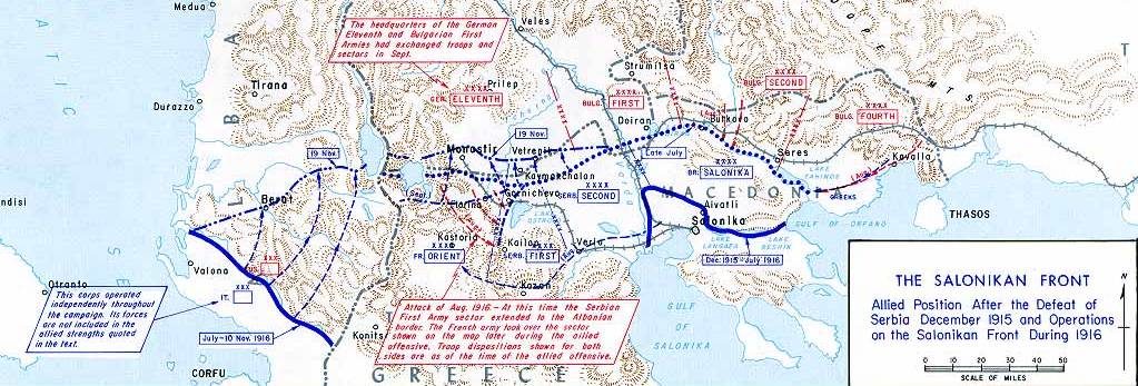
English: Operations at the border of Greece and Serbia, 1916.
his map was created by the Department of Military Art and Engineering, at the U.S. Military Academy (West Point). The initial version was created under the supervision of General Vincent Esposito in 1959. It is now available on the West Point |
||||||
| תאריך יצירה | |||||||
| מקור | West Point | ||||||
| יוצר | General Vincent Esposito | ||||||
| אישורים והיתרים (שימוש חוזר בקובץ זה) |
|
||||||
| גרסאות אחרות |
  |
||||||

היסטוריית הקובץ
ניתן ללחוץ על תאריך/שעה כדי לראות את הקובץ כפי שנראה באותו זמן.
| תאריך/שעה | תמונה ממוזערת | ממדים | משתמש | הערה | |
|---|---|---|---|---|---|
| נוכחית | 21:55, 21 בדצמבר 2006 | 347 × 1,023 (99 ק"ב) | Electionworld (שיחה | תרומות) | {{ew|en|Cglassey}} == Summary == Operations at the border of Greece and Serbia, 1916. his map was created by the Department of Military Art and Engineering, at the U.S. Military Academy (West Point). The initial version was created under the supervision |
אין באפשרותך לדרוס את הקובץ הזה.
שימוש בקובץ
הדפים הבאים משתמשים בקובץ הזה:
שימוש גלובלי בקובץ
אתרי הוויקי השונים הבאים משתמשים בקובץ זה:
- שימוש באתר ar.wikipedia.org
- שימוש באתר azb.wikipedia.org
- שימוש באתר az.wikipedia.org
- שימוש באתר be-tarask.wikipedia.org
- שימוש באתר be.wikipedia.org
- שימוש באתר bg.wikipedia.org
- שימוש באתר bs.wikipedia.org
- שימוש באתר ca.wikipedia.org
- שימוש באתר de.wikipedia.org
- שימוש באתר el.wikipedia.org
- שימוש באתר en.wikipedia.org
- History of modern Macedonia (Greece)
- Maurice Sarrail
- Macedonian front
- Battle of Doiran (1917)
- Greece during World War I
- Monastir offensive
- Autonomous Province of Korçë
- Bulgarian occupation of Albania
- World War I in Albania
- Battle of the Crna Bend (1917)
- User:GerardM/Battles including the Ottoman Empire
- User:Falcaorib
- User:BoDr12/sandbox
- שימוש באתר es.wikipedia.org
- שימוש באתר fa.wikipedia.org
- שימוש באתר fr.wikipedia.org
- שימוש באתר he.wikipedia.org
- שימוש באתר hr.wikipedia.org
- שימוש באתר hu.wikipedia.org
צפייה בשימושים גלובליים נוספים של קובץ זה.