File:South Africa Western Cape relief location map.svg
Jump to navigation
Jump to search

ഈ SVG പ്രമാണത്തിന്റെ PNG പ്രിവ്യൂവിന്റെ വലിപ്പം: 749 × 600 പിക്സലുകൾ. മറ്റ് റെസലൂഷനുകൾ: 300 × 240 പിക്സലുകൾ | 600 × 480 പിക്സലുകൾ | 959 × 768 പിക്സലുകൾ | 1,279 × 1,024 പിക്സലുകൾ | 2,558 × 2,048 പിക്സലുകൾ | 1,214 × 972 പിക്സലുകൾ.
പൂർണ്ണ വലിപ്പം (എസ്.വി.ജി. പ്രമാണം, നാമമാത്രമായ 1,214 × 972 പിക്സലുകൾ, പ്രമാണത്തിന്റെ വലിപ്പം: 1.98 എം.ബി.)
തലവാചകം
തലവാചകങ്ങൾ
ഈ പ്രമാണം എന്തിനെ പ്രതിനിധീകരിക്കുന്നുവെന്ന ഒറ്റവരി വിശദീകരണം ചേർക്കുക
| വിവരണം |
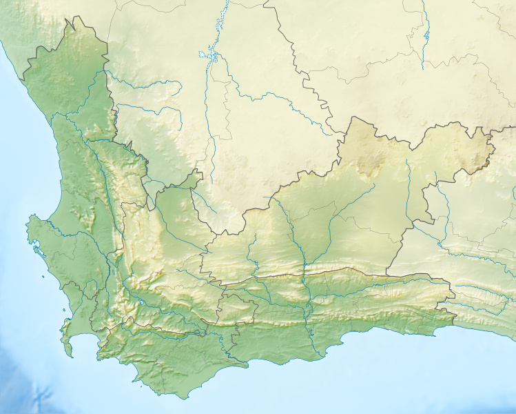
English: Relief location map of the Western Cape
Equirectangular projection, N/S stretching 118%. Geographic limits of the map:
|
| തീയതി | |
| സ്രോതസ്സ് |
|
| സ്രഷ്ടാവ് | Htonl |
| അനുമതി (ഈ പ്രമാണത്തിന്റെ പുനരുപയോഗം) |
ഈ സൃഷ്ടിയുടെ പകർപ്പവകാശ ഉടമയായ ഞാൻ, താഴെ പറയുന്ന അനുമതിയിൽ ഈ സൃഷ്ടി ഇതിനാൽ പ്രസിദ്ധീകരിക്കുന്നു: ഈ പ്രമാണത്തിന് അനുമതി നൽകപ്പെട്ടിരിക്കുന്നത് ക്രിയേറ്റീവ് കോമൺസ് ആട്രിബ്യൂഷൻ-ഷെയർ എലൈക് 3.0 അൺപോർട്ടഡ് അനുവാദപത്ര പ്രകാരമാണ്.
|
| മറ്റു പതിപ്പുകൾ | File:South Africa Western Cape location map.svg |
പ്രമാണ നാൾവഴി
ഏതെങ്കിലും തീയതി/സമയ കണ്ണിയിൽ ഞെക്കിയാൽ പ്രസ്തുതസമയത്ത് ഈ പ്രമാണം എങ്ങനെയായിരുന്നു എന്നു കാണാം.
| തീയതി/സമയം | ലഘുചിത്രം | അളവുകൾ | ഉപയോക്താവ് | അഭിപ്രായം | |
|---|---|---|---|---|---|
| നിലവിലുള്ളത് | 19:44, 4 ജനുവരി 2013 | | 1,214 × 972 (1.98 എം.ബി.) | Htonl (സംവാദം | സംഭാവനകൾ) | {{Information |Description ={{en|1=Relief location map of the Western Cape Equirectangular projection, N/S stretching 118%. Geographic limits of the map: * N: 30.25° S * S: 35.0° S * W: 17.5° E * E: 24.5° E}} |Source ... |
ഈ പ്രമാണത്തിനു മുകളിൽ മറ്റൊരു പ്രമാണം ചേർക്കാൻ താങ്കൾക്ക് കഴിയില്ല.
പ്രമാണത്തിന്റെ ഉപയോഗം
ഈ പ്രമാണം വിക്കിയിലെ താളുകളിലൊന്നിലും ഉപയോഗിക്കുന്നില്ല.
പ്രമാണത്തിന്റെ ആഗോള ഉപയോഗം
താഴെ കൊടുത്തിരിക്കുന്ന മറ്റ് വിക്കികൾ ഈ പ്രമാണം ഉപയോഗിക്കുന്നു:
- ar.wikipedia.org സംരംഭത്തിലെ ഉപയോഗം
- ban.wikipedia.org സംരംഭത്തിലെ ഉപയോഗം
- be.wikipedia.org സംരംഭത്തിലെ ഉപയോഗം
- bg.wikipedia.org സംരംഭത്തിലെ ഉപയോഗം
- ceb.wikipedia.org സംരംഭത്തിലെ ഉപയോഗം
- de.wikipedia.org സംരംഭത്തിലെ ഉപയോഗം
- Tafelbucht
- Boulders Beach
- Saldanha Bay
- Montagu-Pass
- Wikipedia:Kartenwerkstatt/Positionskarten/Afrika
- Dyer Island (Südafrika)
- False Bay
- Vorlage:Positionskarte Südafrika Westkap
- Duiker Island
- Benutzer:Pechristener/Baustelle
- Dassen Island
- Benutzer:Olga Ernst/Walker Bay (Südafrika)
- Walker Bay (Südafrika)
- Matroosberg
- Outeniqua-Pass
- Still Bay
- Sankt-Helena-Bucht
- Bergwerk Steenkampskraal
- Robinson-Pass (Südafrika)
- Garcias-Pass
- en.wikipedia.org സംരംഭത്തിലെ ഉപയോഗം
- Stellenbosch
- Cederberg
- False Bay
- Chapman's Peak
- Blombos Cave
- Dassen Island
- Rondevlei Nature Reserve
- Seal Island, South Africa
- Marloth Nature Reserve
- Karoo National Park
- Dimension Data Pro-Am
- BOS 400
- De Hoop Nature Reserve
- Duiker Island
- Hex River Mountains
- Arniston (East Indiaman)
- Boosmansbos Wilderness Area
- Johanna (East Indiaman)
ഈ പ്രമാണത്തിന്റെ കൂടുതൽ ആഗോള ഉപയോഗം കാണുക.