File:Sumatra.A2001190.0359 lrg.jpg
원본 파일 (4,400 × 3,400 픽셀, 파일 크기: 1.81 MB, MIME 종류: image/jpeg)
캡션
설명
파일 설명
[편집]
- Source: NASA Visible Earth. [1]
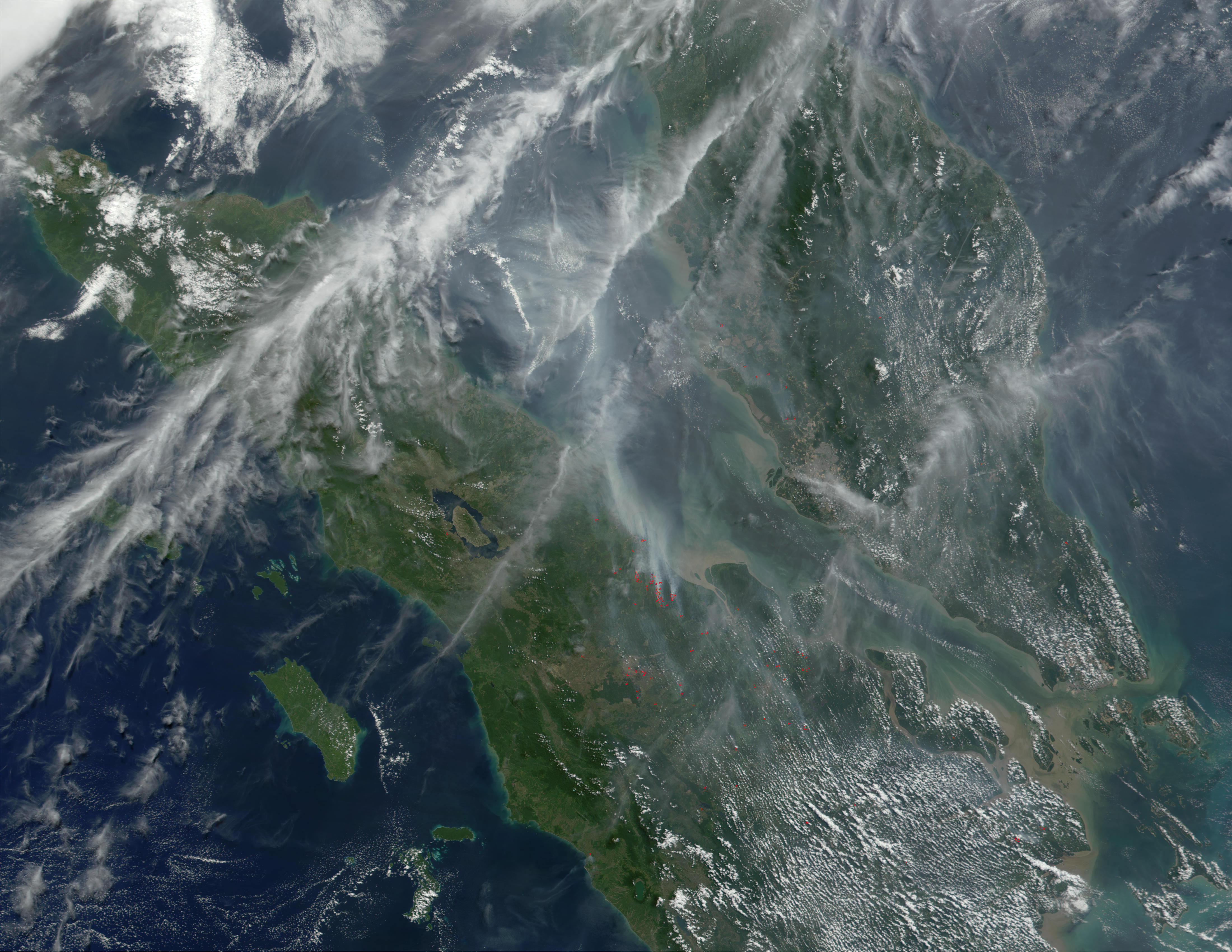
Haze over Malaysia
At least once a year for a period lasting from a week to several months, northern Sumatra is obscured by smoke and haze produced by agricultural burning and forest fires. These data products from the Multi-angle Imaging SpectroRadiometer (MISR) document the presence of airborne particulates on March 13, 2002. On the left is an image acquired by MISR’s 70-degree backward- viewing camera. On the right is a map of aerosol optical depth, a measure of the abundance of atmospheric particulates. This product utilized a test version of the MISR retrieval that incorporates an experimental set of aerosol mixtures. The haze has completely obscured northeastern Sumatra and part of the Strait of Malacca, which separates Sumatra and the Malaysian Peninsula. A northward gradient is apparent as the haze dissipates in the direction of the Malaysian landmass. Each panel covers an area of about 760 kilometers x 400 kilometers.
Haze conditions had posed a health concern during late February (when schools in some parts of North Sumatra were closed), and worsened considerably in the first two weeks of March. By mid-March, local meteorology officials asked residents of North Sumatra’s provincial capital, Medan, to minimize their outdoor activities and wear protective masks. Poor visibility at Medan airport forced a passenger plane to divert to Malaysia on March 14, and visibility reportedly ranged between 100 and 600 meters in some coastal towns southeast of Medan.
The number and severity of this year’s fires was exacerbated by dry weather conditions associated with the onset of a weak to moderate El Niño. The governments of Indonesia, Malaysia, and Brunei have agreed to ban open burning in plantation and forest areas. The enforcement of such fire bans, however, has proven to be an extremely challenging task.
라이선스
[편집]
| 이 파일은 NASA에서 제작하였으므로 퍼블릭 도메인입니다. NASA의 저작권 정책에 따르면 NASA의 자료는 명시하지 않는 이상 저작권의 보호를 받지 않습니다. (Template:PD-USGov, 또는 NASA 저작권 정책 문서, JPL 그림 사용 정책을 참고하세요.) | ||
 |
주의사항:
|
파일 역사
날짜/시간 링크를 클릭하면 해당 시간의 파일을 볼 수 있습니다.
| 날짜/시간 | 섬네일 | 크기 | 사용자 | 설명 | |
|---|---|---|---|---|---|
| 현재 | 2005년 10월 7일 (금) 11:14 | | 4,400 × 3,400 (1.81 MB) | ChongDae (토론 | 기여) | *Source: NASA Visible Earth. [http://visibleearth.nasa.gov/view_rec.php?id=1860] '''Haze over Malaysia''' At least once a year for a period lasting from a week to several months, northern Sumatra is obscured by smoke and haze produced by agricultural |
이 파일을 덮어쓸 수 없습니다.
이 파일을 사용하는 문서
다음 문서 1개가 이 파일을 사용하고 있습니다:
이 파일을 사용하고 있는 모든 위키의 문서 목록
다음 위키에서 이 파일을 사용하고 있습니다:
- ar.wikipedia.org에서 이 파일을 사용하고 있는 문서 목록
- bn.wikipedia.org에서 이 파일을 사용하고 있는 문서 목록
- fr.wikipedia.org에서 이 파일을 사용하고 있는 문서 목록
- id.wikipedia.org에서 이 파일을 사용하고 있는 문서 목록
- it.wikipedia.org에서 이 파일을 사용하고 있는 문서 목록
- ko.wikipedia.org에서 이 파일을 사용하고 있는 문서 목록
- pl.wikipedia.org에서 이 파일을 사용하고 있는 문서 목록
- sr.wikipedia.org에서 이 파일을 사용하고 있는 문서 목록
- uk.wikipedia.org에서 이 파일을 사용하고 있는 문서 목록