<nowiki>མ་ལིའུ་ཅ་མཚོ་འགག; Malakkasund; Selat Melaka; Strait of Malacca; Малака; آبنائے ملاکا; آبنائے ملاکا; Melacký prieliv; Малаккська протока; Seulat Malaka; 马六甲海峡; 믈라카 해협; Malakkafjørður; Malaka Markolo; Малачки Проток; Malajski prolaz; آبنائے ملاکا; মালাক্কা প্রণালী; détroit de Malacca; Selat Melaka; سلت ملاک; Cieśnina Malakka; मलाक्क्याची सामुद्रधुनी; 马六甲海峡; eo biển Malacca; მალაკიშ საროტი; Malakas šaurums; Straat van Malakka; Малајски мореуз; ᱢᱟᱞᱟᱠᱠᱟ ᱮᱥᱴᱮᱨᱮᱴ; Strjitte fan Malakka; Estreito de Malaca; Strait o Malacca; Strooss vu Malakka; Malakkasundet; Malakkastredet; Malakka boğazı; Selat Malaka; Selat Malaka; 馬六甲海峽; دەربەندی مالاکا; Strait of Malacca; مضيق ملقا; Strizh-mor Malaka; ช่องแคบมะละกา; မလက္ကာရေလက်ကြား; 馬六甲海峽; Malaka-szoros; Strâmtoarea Malacca; Estrech de Malaca; Malakako itsasartea; Straat Malakka; Estrechu de Malaca; estret de Malaca; Малакка боғаҙы; Straße von Malakka; Mā-lăk-gă Hāi-hiĕk; Малакскі праліў; تنگه مالاکا; 马六甲海峡; Tengava Malakayê; მალაკის სრუტე; マラッカ海峡; Fretum Malaccense; Selat Malaka; Malackasundet; Estrecho han Malacca; מצר מלאקה; Малакка бугазы; Malakka boʻgʻozi; मलक्का जलडमरूमध्य; మలక్కా జలసంధి; Malakansalmi; Struat faan Malakka; Strait of Malacca; Στενό της Μαλάκα; மலாக்கா நீரிணை; Stretto di Malacca; मलक्का जलसन्धि; Malakka Boğazı; Malaccastrædet; Малацкая пратока; Малаккский пролив; Mâ-liuk-kap Hói-hia̍p; ច្រកមលក្កា; Մալակկայի նեղուց; ਮਲੱਕਾ ਪਣਜੋੜ; Estrecho de Malaca; Estreito de Malaca; Malacca Hái-kiap; Malaka väin; Malacký průliv; Malakos sąsiauris; Melaški preliv; Kipot ng Malaka; 馬六甲海峽; Малакка кысыгы; Selat Malaka (estretso); Mlango wa Malakka; മലാക്കാ കടലിടുക്ക്; Malajski prolaz; Strasse von Malakka; Culfor Malacca; Малајски мореуз; Stretajo di Malaka; Estreito de Malaca; Malajski prolaz; Strait of Malacca; Selat Malaka; estrecho de mar del sudeste asiático; মালয় উপদ্বীপ এবং ইন্দোনেশিয়ার সুমাত্রা দ্বীপের মধ্যবর্তী প্রণালী; détroit entre la péninsule malaise et l'île indonésienne de Sumatra; supitan kang mapan antarané Indonésia lan Malaysia; пратока паміж Індакітаем і Суматрай; eo biển nằm giữa bán đảo Mã Lai và đảo Sumatra, nối Biển Đông và Ấn Độ Dương; estret que separa la península de Malaca de l'illa indonèsia de Sumatra; 位于马来半岛与苏门答腊岛之间的海峡; Meerenge zwischen Sumatra und der Malaiischen Halbinsel; Via de navegação marítima; strait in Malaysia; мореуз између Малајског полуострва и индонежанског острва Суматра, који повезује Сингапурски мореуз и Јужно кинеско море, на југоистоку, са Андаманским морем које граничи са Индијским океаном, на северозападу; 位於馬來半島與蘇門答臘島之間的海峽; مضيق في ماليزيا; Malezya Yarımadası ve Sumatra adası arasında 805 km uzunluğunda dar bir boğaz; マレー半島とスマトラ島を隔てる海峡; strait between the Malay Peninsula and the Indonesian island of Sumatra; strait in Malaysia; salah satu selat di dunia; cieśnina pomiędzy Półwyspem Malajskim a Sumatrą; zeestraat tussen Indonesië en Maleisië; 位於馬來半島與蘇門答臘島之間的海峽; selat di antara Semenanjung Tanah Melayu dan Sumatera; пролив между Малайским полуостровом и Суматрой; మలేషియా ఇండోనేషియాల మధ్య ఉన్న జలసంధి; Malakan niemimaan ja Sumatran välinen salmi; Vía de navegación marítima; markolo inter la Malaka Duoninsulo kaj insulo Sumatro en suda Azio; strait between the Malay Peninsula and the Indonesian island of Sumatra, linking the Singapore Strait and the Southern China Sea, to the south-east, with the Andaman Sea bordering the Indian Ocean, to the north-west; மலாயத் தீபகற்பத்துக்கும் சுமாத்திராத் தீவுக்குமிடையிலான நீரிணை; Estrecho de Melaka; Malacca-szoros; Молуккский пролив; Малайский пролив; Малакский пролив; Malakkastraße; Straße von Malacca; Malakka-Straße; Meerenge von Malakka; Малајски пролаз; 麻六甲海峽; 馬六甲海峽; Tengava Malakka; Malacca Boğazı; Malaka Boğazı; آبنائے ملکا; Selat Malaka (sund); מצר מלקה; מצרי מאלאקה; מיצרי מאלקה; מיצרי מלקה; מצרי מאלקה; מיצר מלקה; מיצרי מאלאקה; מצרי מלקה; मलक्का जलसन्धि; मलक्का जलसंधि; క్రా జలసంధి; 말라카 해협; 말라까 해협; 말라까해협; மலாக்கா நீரிணைவு; மலாக்கா ஜலசந்தி; détroit de Kra; Selat Malaka; मलाक्का सामुद्रधुनी; Malakan salmi; eo biển Ma-lắc-ca; Strizh-mor Melaka; تنگه ملاکا; خلیج عقبه; تنگه ی ملاکا; تنگهی ملاکا; シンガポール海峡; Strjitte Malakka; Malakkastrædet; Kipot ng Malacca; Пролива Малака; Малайски проток; Малакски проток; ច្រកម៉ាឡាកា; Selat Kra; Sempitan Malaka; Malajski tjesnac; Malaccastredet; Malakkasundet; Straat van Malakka; Straat Malacca; Straat van Malacca; Malacca Strait; Strait of Malacca; Malakka Boʻgʻozi; Malakka bo‘g‘ozi; Malakka Bo‘g‘ozi; Malakka bo`g`ozi; Malakka Bo`g`ozi; Malakka bo'g'ozi; Malakka Bo'g'ozi; Estreito de Málaca; Malacca Strait; Strait of Kra; Kra Strait; مضيق ملقة; πορθμός της Μαλάκα; Πορθμός της Μαλάκκα; Malacký prieliv; Malakkský prieliv</nowiki>
Strait of Malacca
strait between the Malay Peninsula and the Indonesian island of Sumatra
The Strait of Malacca is a narrow, 930 km (580 mile) stretch of water between the Malaysian peninsula (in western Malaysia) and the island of Sumatra (in western Indonesia). It is named after the state of Melaka, Malaysia.
This is a main category requiring frequent diffusion and maybe maintenance. As many pictures and media files as possible should be moved into appropriate subcategories.
Subcategories
This category has the following 12 subcategories, out of 12 total.


 120618-N-HI414-116 (7420190944).jpg 2,100 × 1,500; 411 KB
 After SunSet Near Singapur - panoramio.jpg 3,072 × 2,304; 1.54 MB
 Bukit Melawati cannons.jpg 2,016 × 1,512; 919 KB
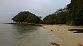 Cape Rachado Beach.jpg 1,056 × 592; 81 KB
 Coast of Port Dickson District and Jimah Power Plant.jpg 4,032 × 3,024; 493 KB
 Hujung Tanjung 3 - panoramio.jpg 1,280 × 1,024; 365 KB
 Islands and ship, Strait of Malacca.jpg 3,072 × 2,304; 1.82 MB
 Islands, Strait of Malacca 2.jpg 3,072 × 2,304; 2.35 MB
 Islands, Strait of Malacca.jpg 3,072 × 2,304; 1.89 MB
 IWM A 28615.JPG 1,389 × 573; 72 KB
 Lexis Hibiscus Port Dickson.jpg 2,300 × 1,520; 1.04 MB
 Malacca Malaysia Malacca-Straits-Mosque-09.jpg 5,127 × 3,418; 5.45 MB
 Melaka-looking-south-from-St-Pauls-Hill-2177.jpg 2,048 × 1,536; 1.7 MB
 Melaka-looking-south-from-St-Pauls-Hill-2178.jpg 2,048 × 1,536; 1.7 MB
 Melaka-mud-flats-N-of-Pulau-Melaka-2233.jpg 2,048 × 1,536; 1.58 MB
 Melaka-shore-2236.jpg 2,048 × 1,536; 1.68 MB
 Melaka-strait.jpg 2,592 × 1,944; 1.9 MB
 Panama canal lock sizes.png 708 × 545; 79 KB
 Panamakanal Schiffsgroessen.svg 693 × 673; 1.13 MB
 Ship on the Strait of Malacca from Bukit Melawati.jpg 2,016 × 1,512; 421 KB
 Ships in the Malacca Strait.jpg 5,472 × 3,080; 9.29 MB
 Ships in the Malacca Straits near Singapore, April 16 2014. (14231680091).jpg 3,888 × 2,592; 2.04 MB
 Strait of Malacca after sunset 2009 - panoramio (29311344).jpg 3,072 × 2,304; 2.7 MB
 Sumatra.A2001190.0359 lrg.jpg 4,400 × 3,400; 1.81 MB
 Target practice.jpg 608 × 913; 450 KB
 Wavesoversunset.jpg 5,397 × 3,598; 2.06 MB
.jpg)


.jpg)
.jpg)


_during_a_transit_of_the_Strait_of_Malacca.jpg)