File:Survey of Palestine, Cæsarea (FL28027725 3805118).jpg
קפיצה לניווט
קפיצה לחיפוש

גודל התצוגה המקדימה הזאת: 545 × 599 פיקסלים. רזולוציות אחרות: 218 × 240 פיקסלים | 437 × 480 פיקסלים | 699 × 768 פיקסלים | 932 × 1,024 פיקסלים | 1,863 × 2,048 פיקסלים | 11,071 × 12,169 פיקסלים.
לקובץ המקורי (11,071 × 12,169 פיקסלים, גודל הקובץ: 159.15 מ"ב, סוג MIME: image/jpeg)
כיתובים
כיתובים
נא להוסיף משפט שמסביר מה הקובץ מייצג
תקציר
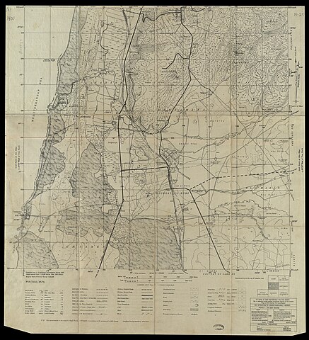
[עריכה]| Cæsarea
( |
||||||||||||||||||||||||
|---|---|---|---|---|---|---|---|---|---|---|---|---|---|---|---|---|---|---|---|---|---|---|---|---|
| אומן |
|
|||||||||||||||||||||||
| כותרת |
Cæsarea |
|||||||||||||||||||||||
| מפרסם |
Survey of Palestine |
|||||||||||||||||||||||
| תיאור |
Cæsarea. Reproduced by the Survey of Palestine. |
|||||||||||||||||||||||
| שפה | אנגלית | |||||||||||||||||||||||
| תאריך הוצאה לאור | 1942 | |||||||||||||||||||||||
| טכניקה | 1 map ; | |||||||||||||||||||||||
| ממדים | 40 × 41 ס"מ | |||||||||||||||||||||||
| אוסף |
|
|||||||||||||||||||||||
| מיקום נוכחי |
|
|||||||||||||||||||||||
| מיקום הוצאה | יפו | |||||||||||||||||||||||
| חיפוש בקטלוג מרחב | יפו | |||||||||||||||||||||||
| הערות |
English: Palestine 1:25,000 ; 14-21 | |||||||||||||||||||||||
| קנה מידה | 1:25,000 cm | |||||||||||||||||||||||
| IE PID | IE28027721 | |||||||||||||||||||||||
| רוזטה שם קובץ | FL28027725 | |||||||||||||||||||||||
| מזהה רשומה בספרייה הלאומית (P3959) | 990038051180205171 | |||||||||||||||||||||||
| חיפוש בקטלוג מרחב | אנגלית, המרכז למיפוי ארץ ישראל | |||||||||||||||||||||||
| חיפוש בקטלוג מרחב | Survey of Palestine | |||||||||||||||||||||||
| מקור/צלם |
|
|||||||||||||||||||||||
| גרסאות אחרות | ||||||||||||||||||||||||
| Jpg / Tif version |
|
|||||||||||||||||||||||

.jpg)

.jpg&action=edit§ion=1)
רישיון
[עריכה].jpg&action=edit§ion=2)
This work created by the United Kingdom Government is in the public domain.
This is because it is one of the following:
HMSO has declared that the expiry of Crown Copyrights applies worldwide (ref: HMSO Email Reply)
|
 |
היסטוריית הקובץ
ניתן ללחוץ על תאריך/שעה כדי לראות את הקובץ כפי שנראה באותו זמן.
| תאריך/שעה | תמונה ממוזערת | ממדים | משתמש | הערה | |
|---|---|---|---|---|---|
| נוכחית | 03:29, 8 באוגוסט 2023 | | 12,169 × 11,071 (159.15 מ"ב) | Geagea (שיחה | תרומות) | pattypan 22.03 |
אין באפשרותך לדרוס את הקובץ הזה.
שימוש בקובץ
הדפים הבאים משתמשים בקובץ הזה:
.jpg&oldid=803405805)