File:Survey of Palestine, Gaza (FL60918674 3809024).jpg
קפיצה לניווט
קפיצה לחיפוש

גודל התצוגה המקדימה הזאת: 734 × 600 פיקסלים. רזולוציות אחרות: 294 × 240 פיקסלים | 587 × 480 פיקסלים | 940 × 768 פיקסלים | 1,253 × 1,024 פיקסלים | 2,506 × 2,048 פיקסלים | 16,170 × 13,216 פיקסלים.
לקובץ המקורי (16,170 × 13,216 פיקסלים, גודל הקובץ: 229.71 מ"ב, סוג MIME: image/jpeg)
כיתובים
כיתובים
נא להוסיף משפט שמסביר מה הקובץ מייצג
תקציר
[עריכה]| Gaza
( |
||||||||||||||||||||||||
|---|---|---|---|---|---|---|---|---|---|---|---|---|---|---|---|---|---|---|---|---|---|---|---|---|
| אומן |
|
|||||||||||||||||||||||
| כותרת |
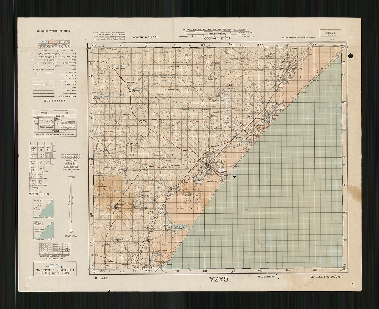
Gaza |
|||||||||||||||||||||||
| מפרסם |
Survey of Palestine |
|||||||||||||||||||||||
| תיאור |
Gaza. Compiled, drawn & reproduced by Survey of Palestine. |
|||||||||||||||||||||||
| שפה | אנגלית | |||||||||||||||||||||||
| תאריך הוצאה לאור | 1945 | |||||||||||||||||||||||
| טכניקה | 1 sheet : color ; | |||||||||||||||||||||||
| ממדים | גובה: 50 ס"מ; רוחב: 62 ס"מ | |||||||||||||||||||||||
| אוסף |
|
|||||||||||||||||||||||
| מיקום נוכחי |
|
|||||||||||||||||||||||
| מיקום הוצאה | יפו | |||||||||||||||||||||||
| חיפוש בקטלוג מרחב | יפו | |||||||||||||||||||||||
| הערות |
Reprinted with minor road revision, S. of P. Dec.1945. English: Palestine. 1:100,000. 1942-1947 ; 11 | |||||||||||||||||||||||
| קנה מידה | 1:100,000 cm | |||||||||||||||||||||||
| IE PID | IE60918672 | |||||||||||||||||||||||
| רוזטה שם קובץ | FL60918674 | |||||||||||||||||||||||
| מזהה רשומה בספרייה הלאומית (P3959) | 990038090240205171 | |||||||||||||||||||||||
| חיפוש בקטלוג מרחב | אנגלית, המרכז למיפוי ארץ ישראל | |||||||||||||||||||||||
| חיפוש בקטלוג מרחב | Survey of Palestine | |||||||||||||||||||||||
| מקור/צלם |
|
|||||||||||||||||||||||
| גרסאות אחרות | ||||||||||||||||||||||||
| Jpg / Tif version |
|
|||||||||||||||||||||||

.jpg)

.jpg&action=edit§ion=1)
רישיון
[עריכה].jpg&action=edit§ion=2)
This work created by the United Kingdom Government is in the public domain.
This is because it is one of the following:
HMSO has declared that the expiry of Crown Copyrights applies worldwide (ref: HMSO Email Reply)
|
 |
היסטוריית הקובץ
ניתן ללחוץ על תאריך/שעה כדי לראות את הקובץ כפי שנראה באותו זמן.
| תאריך/שעה | תמונה ממוזערת | ממדים | משתמש | הערה | |
|---|---|---|---|---|---|
| נוכחית | 13:42, 9 באוגוסט 2023 | | 13,216 × 16,170 (229.71 מ"ב) | Geagea (שיחה | תרומות) | pattypan 22.03 |
אין באפשרותך לדרוס את הקובץ הזה.
שימוש בקובץ
הדפים הבאים משתמשים בקובץ הזה:
.jpg&redirect=no)
.jpg&oldid=792157764)