File:Survey of Palestine, Jerusalem 22-VII-D (FL191853727 2367708).jpg
קפיצה לניווט
קפיצה לחיפוש

גודל התצוגה המקדימה הזאת: 552 × 599 פיקסלים. רזולוציות אחרות: 221 × 240 פיקסלים | 442 × 480 פיקסלים | 707 × 768 פיקסלים | 943 × 1,024 פיקסלים | 1,886 × 2,048 פיקסלים | 14,486 × 15,730 פיקסלים.
לקובץ המקורי (14,486 × 15,730 פיקסלים, גודל הקובץ: 245.82 מ"ב, סוג MIME: image/jpeg)
כיתובים
כיתובים
נא להוסיף משפט שמסביר מה הקובץ מייצג
תקציר
[עריכה]| Jerusalem
( |
||||||||||||||||||||||||
|---|---|---|---|---|---|---|---|---|---|---|---|---|---|---|---|---|---|---|---|---|---|---|---|---|
| אומן |
|
|||||||||||||||||||||||
| כותרת |
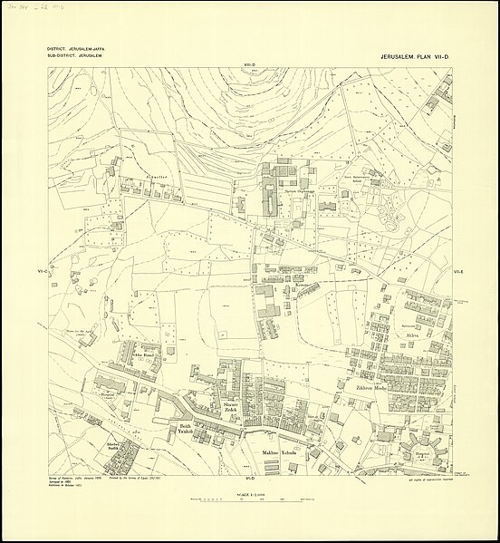
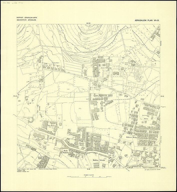
Jerusalem |
|||||||||||||||||||||||
| מפרסם |
Survey of Egypt |
|||||||||||||||||||||||
| תיאור |
Jerusalem. Survey of Palestine. |
|||||||||||||||||||||||
| שפה | אנגלית | |||||||||||||||||||||||
| תאריך הוצאה לאור | 1925 | |||||||||||||||||||||||
| אוסף |
|
|||||||||||||||||||||||
| מיקום נוכחי |
|
|||||||||||||||||||||||
| מיקום הוצאה | יפו | |||||||||||||||||||||||
| חיפוש בקטלוג מרחב | יפו | |||||||||||||||||||||||
| הערות |
Surveyed in 1921-1922, additions 1924, Survey of Palestine, Jaffa, Jan. 1925, Printed by the Survey of Egypt; Link to Digital version of map in Albright Institue: https://aiar.userservices.exlibrisgroup.com/view/delivery/972AI_INST/127799590002696 List: [V-D, V-E, V-F, V-G, VI-D, VI-E, VI-F, VI-G, VII-D, VII-E, VII-G Photography by Ardon Bar-Hama courtesy of George Blumenthal; VII-F © Hebrew University in Jerusalem]; כולל סימון מגדל שעון בכיכר אלנבי [=כיכר צהל].;$aSheet V-D Princess house [Jeanne Merkus]. English: Jerusalem. 1:2,000 | |||||||||||||||||||||||
| קנה מידה | 1:2,000 cm | |||||||||||||||||||||||
| IE PID | IE191853706 | |||||||||||||||||||||||
| רוזטה שם קובץ | FL191853727 | |||||||||||||||||||||||
| מזהה רשומה בספרייה הלאומית (P3959) | 990023677080205171 | |||||||||||||||||||||||
| חיפוש בקטלוג מרחב | אנגלית, המרכז למיפוי ארץ ישראל | |||||||||||||||||||||||
| חיפוש בקטלוג מרחב | Survey of Egypt | |||||||||||||||||||||||
| מקור/צלם |
|
|||||||||||||||||||||||
| גרסאות אחרות | ||||||||||||||||||||||||
| Jpg / Tif version |
|
|||||||||||||||||||||||

.jpg)

.jpg&action=edit§ion=1)
רישיון
[עריכה].jpg&action=edit§ion=2)
This work created by the United Kingdom Government is in the public domain.
This is because it is one of the following:
HMSO has declared that the expiry of Crown Copyrights applies worldwide (ref: HMSO Email Reply)
|
 |
היסטוריית הקובץ
ניתן ללחוץ על תאריך/שעה כדי לראות את הקובץ כפי שנראה באותו זמן.
| תאריך/שעה | תמונה ממוזערת | ממדים | משתמש | הערה | |
|---|---|---|---|---|---|
| נוכחית | 08:59, 31 ביולי 2023 | | 15,730 × 14,486 (245.82 מ"ב) | Geagea (שיחה | תרומות) | pattypan 22.03 |
אין באפשרותך לדרוס את הקובץ הזה.
שימוש בקובץ
הדף הבא משתמש בקובץ הזה:
.jpg&oldid=788743208)