File:Texas and Pacific Railway Shortest Line to the Great Cotton, Grain and Stock Regions of Texas 1878 UTA.jpg
Vai alla navigazione
Vai alla ricerca

Dimensioni di questa anteprima: 653 × 600 pixel. Altre risoluzioni: 261 × 240 pixel | 523 × 480 pixel | 836 × 768 pixel | 1 115 × 1 024 pixel | 2 230 × 2 048 pixel | 2 927 × 2 688 pixel.
File originale (2 927 × 2 688 pixel, dimensione del file: 1,86 MB, tipo MIME: image/jpeg)
Didascalie
Didascalie
Aggiungi una brevissima spiegazione di ciò che questo file rappresenta
Dettagli
[modifica]
| Titolo |
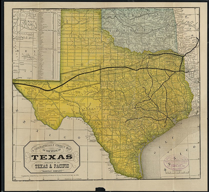
English: A Geographically Correct Map of the State of Texas |
||||||||||||||||||||||||||
| Data | |||||||||||||||||||||||||||
| Fonte | UTA Libraries Cartographic Connections: mappa / testo | ||||||||||||||||||||||||||
| Creatore |
Sconosciuto |
||||||||||||||||||||||||||
| Attribuzione |
English: The University of Texas at Arlington Libraries Special Collections |
||||||||||||||||||||||||||
| Geotemporal data | |||||||||||||||||||||||||||
| Map location | Texas | ||||||||||||||||||||||||||
| Georeferencing | If inappropriate please set warp_status = skip to hide. | ||||||||||||||||||||||||||
| Bibliographic data | |||||||||||||||||||||||||||
| Luogo di pubblicazione | Saint Louis | ||||||||||||||||||||||||||
| Casa editrice |
Woodward, Tiernan & Hale (for the Texas & Pacific Railway Company) |
||||||||||||||||||||||||||
| Archival data | |||||||||||||||||||||||||||
| Collezione |
|
||||||||||||||||||||||||||
Licenza
[modifica]

|
This file was provided to Wikimedia Commons by the University of Texas at Arlington Libraries as part of a cooperation project. The University of Texas at Arlington Libraries is part of the University of Texas at Arlington, a public research university located in Arlington, Texas.
|
This work was published before January 1, 1929 and it is anonymous or pseudonymous due to unknown authorship. It is in the public domain in the United States as well as countries and areas where the copyright terms of anonymous or pseudonymous works are 95 years or fewer since publication.
|
Cronologia del file
Fare clic su un gruppo data/ora per vedere il file come si presentava nel momento indicato.
| Data/Ora | Miniatura | Dimensioni | Utente | Commento | |
|---|---|---|---|---|---|
| attuale | 20:06, 2 apr 2022 | | 2 927 × 2 688 (1,86 MB) | Michael Barera (discussione | contributi) | == {{int:filedesc}} == {{Map |title = {{en|'''''A Geographically Correct Map of the State of Texas'''''}} |description = |legend = |author = {{Unknown|author}} |date = 1878 |source = UTA Libraries ''Cartographic Connections'': [https://libguides.uta.edu/ld.php?content_id=931877 {{I18n/map}}] / [https://libguides.uta.edu/ccon {{I18n/text}}] |permission = |map date = |location = {{Texas}} |projec... |
Impossibile sovrascrivere questo file.
Utilizzo del file
Le seguenti 4 pagine usano questo file:
Utilizzo globale del file
Anche i seguenti wiki usano questo file:
- Usato nelle seguenti pagine di de.wikipedia.org:
- Usato nelle seguenti pagine di en.wikipedia.org:
- Usato nelle seguenti pagine di fr.wikipedia.org:
- Usato nelle seguenti pagine di it.wikipedia.org: