File:The Bunker Hill Steps linking Hope Street to Fifth Street in Los Angeles, California LCCN2013632115.tif
קפיצה לניווט
קפיצה לחיפוש

גודל התצוגה המקדימה הזאת מסוג JPG של קובץ ה־TIF הזה: 800 × 534 פיקסלים. רזולוציות אחרות: 320 × 214 פיקסלים | 640 × 427 פיקסלים | 1,024 × 683 פיקסלים | 1,280 × 854 פיקסלים | 2,560 × 1,709 פיקסלים | 7,360 × 4,912 פיקסלים.
לקובץ המקורי (7,360 × 4,912 פיקסלים, גודל הקובץ: 206.9 מ"ב, סוג MIME: image/tiff)
כיתובים
כיתובים
נא להוסיף משפט שמסביר מה הקובץ מייצג
תקציר[עריכה]
| תיאור |
English: Title: The Bunker Hill Steps linking Hope Street to Fifth Street in Los Angeles, California
Physical description: 1 photograph : digital, tiff file, color. Notes: Title, date, and keywords provided by the photographer.; Credit line: The Jon B. Lovelace Collection of California Photographs in Carol M. Highsmith's America Project, Library of Congress, Prints and Photographs Division.; Gift; The Capital Group Companies Charitable Foundation in memory of Jon B. Lovelace; 2012; (DLC/PP-2012:063).; The steps are Los Angeles' architectural translation of Rome's Spanish Steps and are often referred to as the "Spanish Steps." Designed by Lawrence Halprin, they are divided by a raised, mock rock bottom cascading water channel that originates at the top.; Forms part of: Jon B. Lovelace Collection of California Photographs in Carol M. Highsmith's America Project in the Carol M. Highsmith Archive. |
||||||||||||||||||||||||||
| תאריך יצירה | |||||||||||||||||||||||||||
| מקור |
Library of Congress
|
||||||||||||||||||||||||||
| יוצר |
|
||||||||||||||||||||||||||
| אישורים והיתרים (שימוש חוזר בקובץ זה) |
No known restrictions on publication.
|
||||||||||||||||||||||||||


| מיקום המצלמה | | תמונה זו ותמונות נוספות במיקום: OpenStreetMap |
|---|
רישיון[עריכה]
| This work is from the Carol M. Highsmith Archive collection at the Library of Congress. According to the library, there are no known copyright restrictions on the use of this work. Carol M. Highsmith has stipulated that her photographs are in the public domain. Photographs of sculpture or other works of art may be restricted by the copyright of the artist. |
 |
היסטוריית הקובץ
ניתן ללחוץ על תאריך/שעה כדי לראות את הקובץ כפי שנראה באותו זמן.
| תאריך/שעה | תמונה ממוזערת | ממדים | משתמש | הערה | |
|---|---|---|---|---|---|
| נוכחית | 00:14, 3 בספטמבר 2016 |  | 4,912 × 7,360 (206.9 מ"ב) | Fæ (שיחה | תרומות) | LOC 2013632115, Carol M. Highsmith collection. P620.8160 TIFF (206.9mb) |
| 00:13, 3 בספטמבר 2016 | 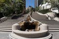 | 4,912 × 7,360 (206.9 מ"ב) | Fæ (שיחה | תרומות) | LOC 2013632115, Carol M. Highsmith collection. P620.8160 TIFF (206.9mb) |
אין באפשרותך לדרוס את הקובץ הזה.
שימוש בקובץ
אין דפים המשתמשים בקובץ זה.
שימוש גלובלי בקובץ
אתרי הוויקי השונים הבאים משתמשים בקובץ זה:
- שימוש באתר he.wikipedia.org