File:Tonlesap.jpg
둘러보기로 이동
검색으로 이동
미리 보기 크기: 597 × 599 픽셀 다른 해상도: 239 × 240 픽셀 | 478 × 480 픽셀 | 765 × 768 픽셀 | 1,020 × 1,024 픽셀 | 2,039 × 2,048 픽셀 | 4,079 × 4,096 픽셀
원본 파일 (4,079 × 4,096 픽셀, 파일 크기: 17.17 MB, MIME 종류: image/jpeg)
캡션
설명
이 파일이 나타내는 바에 대한 한 줄 설명을 추가합니다
| 설명 |
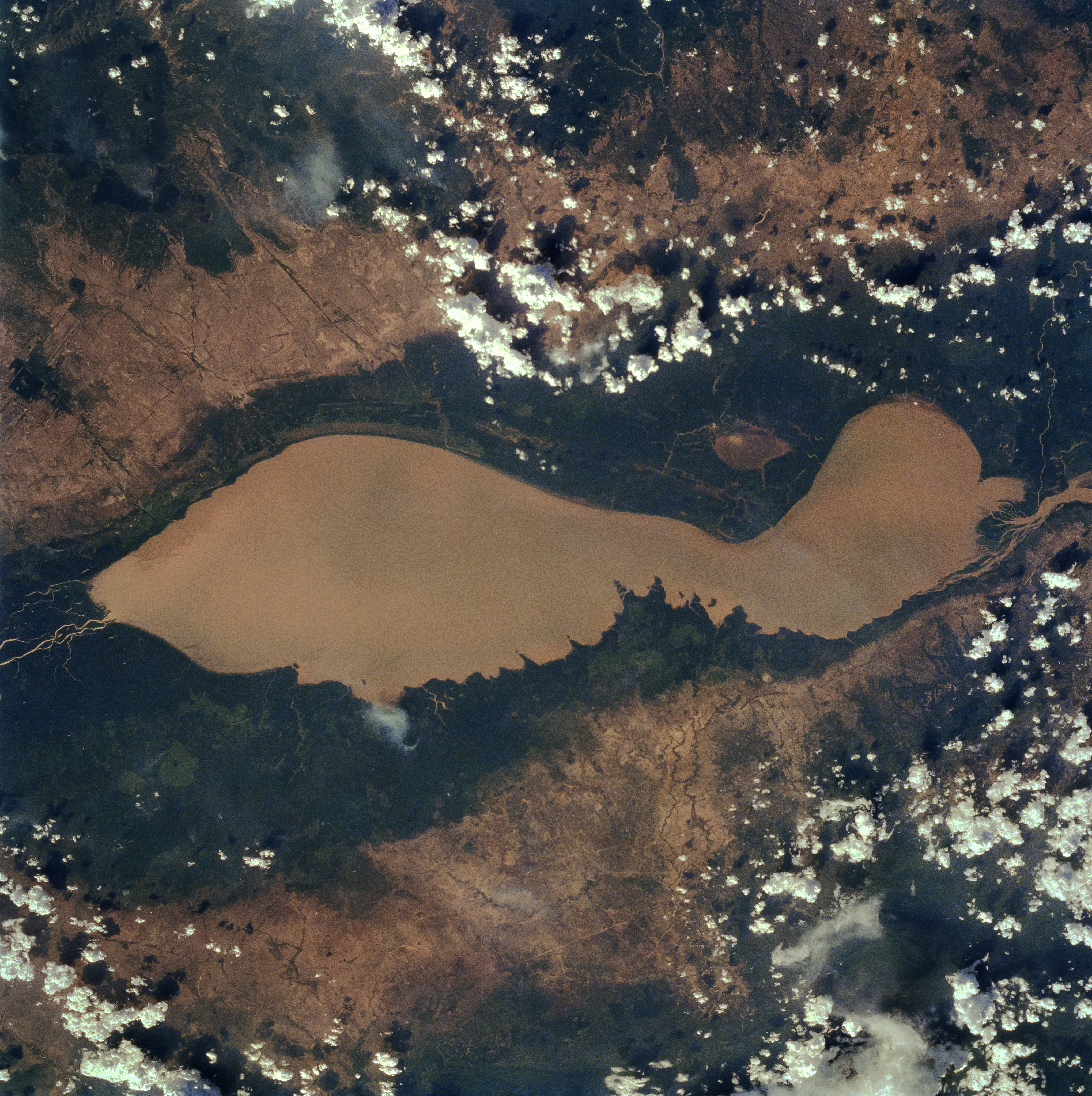
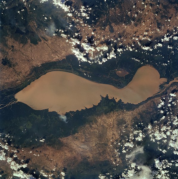
English: The Tonle Sap (also know as the Great Lake) occupies a depression in the Cambodian Plain and is a shallow silt-laden lake. It is the largest lake in Southeast Asia and is fed by many streams. The Tonle Sap is drained by the Tonle Sab River (upper center), which flows south-southeast to the Mekong River (not visible on the image). The river connecting the Tonle Sap with the Mekong creates a unique phenomenon not known in any other part of the world: reversing its direction of flow twice a year. For most of the time, the Tonle Sab River flows from the lake to the Mekong River near the capital city of Phnom Penh. However, during the Southeast Asian monsoon season from June to November, when the Mekong drains large areas of Southeast Asia, the Tonle Sab flows from the Mekong back into the Tonle Sap. During the monsoon season, the Tonle Sap increases from 1000 sq. miles (2600 sq. km) to near 4020 sq. miles (10400 sq. km) raising the lake level 30 feet (9 meters), causing enormous floods in the region surrounding the lake. |
| 날짜 | |
| 출처 |
Earth from Space - Image Information Gateway to Astronaut Photography of Earth |
| 저자 | NASA/Johnson Space Center |
| 저작권 (이 파일을 인용하기) |
PD-USGov-NASA |
This image or video was catalogued by one of the centers of the United States National Aeronautics and Space Administration (NASA) under Photo ID: STS059-84-80. This tag does not indicate the copyright status of the attached work. A normal copyright tag is still required. See Commons:Licensing. Other languages:
|
| 이 파일은 NASA에서 제작하였으므로 퍼블릭 도메인입니다. NASA의 저작권 정책에 따르면 NASA의 자료는 명시하지 않는 이상 저작권의 보호를 받지 않습니다. (Template:PD-USGov, 또는 NASA 저작권 정책 문서, JPL 그림 사용 정책을 참고하세요.) | ||
 |
주의사항:
|
파일 역사
날짜/시간 링크를 클릭하면 해당 시간의 파일을 볼 수 있습니다.
| 날짜/시간 | 섬네일 | 크기 | 사용자 | 설명 | |
|---|---|---|---|---|---|
| 현재 | 2022년 4월 4일 (월) 10:40 | | 4,079 × 4,096 (17.17 MB) | Tiouraren (토론 | 기여) | larger version |
| 2015년 7월 15일 (수) 06:48 |  | 902 × 695 (293 KB) | Wikirictor (토론 | 기여) | i re-sized it, enhanced its quality and rotated it in order to have north on top. | |
| 2006년 6월 18일 (일) 05:04 |  | 637 × 640 (53 KB) | Georgio~commonswiki (토론 | 기여) | {{Information |Description=Earth Sciences and Image Analysis, NASA-Johnson Space Center. 16 Apr. 2004. "Earth from Space - Image Information." |Source=http://earth.jsc.nasa.gov/sseop/efs/photoinfo.pl?PHOTO=STS059-84-80 |Date=16 Apr. 2004. |Author=NASA |Pe |
이 파일을 덮어쓸 수 없습니다.
이 파일을 사용하는 문서
다음 문서 2개가 이 파일을 사용하고 있습니다:
이 파일을 사용하고 있는 모든 위키의 문서 목록
다음 위키에서 이 파일을 사용하고 있습니다:
- af.wikipedia.org에서 이 파일을 사용하고 있는 문서 목록
- ar.wikipedia.org에서 이 파일을 사용하고 있는 문서 목록
- az.wikipedia.org에서 이 파일을 사용하고 있는 문서 목록
- bg.wikipedia.org에서 이 파일을 사용하고 있는 문서 목록
- ca.wikipedia.org에서 이 파일을 사용하고 있는 문서 목록
- ceb.wikipedia.org에서 이 파일을 사용하고 있는 문서 목록
- cv.wikipedia.org에서 이 파일을 사용하고 있는 문서 목록
- cy.wikipedia.org에서 이 파일을 사용하고 있는 문서 목록
- en.wikipedia.org에서 이 파일을 사용하고 있는 문서 목록
- en.wikivoyage.org에서 이 파일을 사용하고 있는 문서 목록
- eo.wikipedia.org에서 이 파일을 사용하고 있는 문서 목록
- es.wikipedia.org에서 이 파일을 사용하고 있는 문서 목록
- eu.wikipedia.org에서 이 파일을 사용하고 있는 문서 목록
- he.wikivoyage.org에서 이 파일을 사용하고 있는 문서 목록
- id.wikipedia.org에서 이 파일을 사용하고 있는 문서 목록
- it.wikipedia.org에서 이 파일을 사용하고 있는 문서 목록
- it.wikivoyage.org에서 이 파일을 사용하고 있는 문서 목록
- ja.wikipedia.org에서 이 파일을 사용하고 있는 문서 목록
- ka.wikipedia.org에서 이 파일을 사용하고 있는 문서 목록
- ko.wikipedia.org에서 이 파일을 사용하고 있는 문서 목록
- ms.wikipedia.org에서 이 파일을 사용하고 있는 문서 목록
- my.wikipedia.org에서 이 파일을 사용하고 있는 문서 목록
- no.wikipedia.org에서 이 파일을 사용하고 있는 문서 목록
- pl.wikipedia.org에서 이 파일을 사용하고 있는 문서 목록
- ru.wikipedia.org에서 이 파일을 사용하고 있는 문서 목록
- sh.wikipedia.org에서 이 파일을 사용하고 있는 문서 목록
- sv.wikipedia.org에서 이 파일을 사용하고 있는 문서 목록
- te.wikipedia.org에서 이 파일을 사용하고 있는 문서 목록
- th.wikipedia.org에서 이 파일을 사용하고 있는 문서 목록
- tl.wikipedia.org에서 이 파일을 사용하고 있는 문서 목록
- uk.wikipedia.org에서 이 파일을 사용하고 있는 문서 목록
- ur.wikipedia.org에서 이 파일을 사용하고 있는 문서 목록
- vi.wikipedia.org에서 이 파일을 사용하고 있는 문서 목록
- war.wikipedia.org에서 이 파일을 사용하고 있는 문서 목록
- www.wikidata.org에서 이 파일을 사용하고 있는 문서 목록
- zh-yue.wikipedia.org에서 이 파일을 사용하고 있는 문서 목록
- zh.wikipedia.org에서 이 파일을 사용하고 있는 문서 목록