File:Vallard map rotated.jpg
Vallard_map_rotated.jpg (795 × 599 pixel, dimensione del file: 149 KB, tipo MIME: image/jpeg)
Didascalie
Didascalie

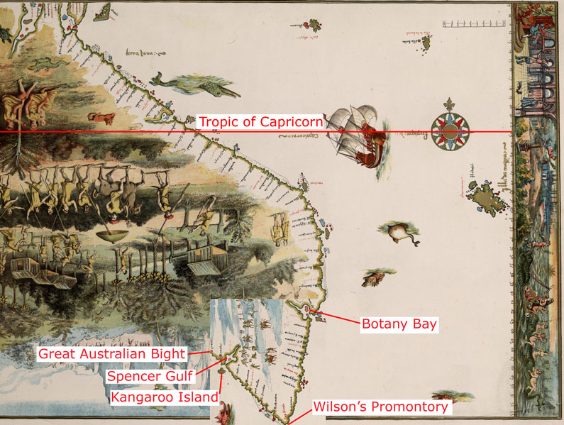
The 1542 Vallard map, with part of the bottom area rotated at 90 degrees, in the same way as described as done by journalist Peter Trickett [1] The image labelled with the claimed modern day locations shown on the map.
It should be noted that the latitude this would give for Wilson's Promontory using the scale visible on the right hand side of the map is 54°S (see: 54°S 145°E / 54°S 145°E) which is far to the south of Tasmania; when Wilson's Promontory is only at 39°S (39°02′S 146°23′E / 39.033°S 146.383°E). The claimed Botany Bay also appears at 43°S which is as far south as Hobart (see: 43°S 147°E / 43°S 147°E), when it is actually only at 33°S (33°58′S 151°10′E / 33.967°S 151.17°E)
|
Quest'opera è nel pubblico dominio anche in tutti i Paesi e nelle aree in cui la durata del copyright è la vita dell'autore più 70 anni o meno.
| |
| Questo file è stato identificato come libero da restrizioni conosciute riguardanti le leggi sul copyright, compresi tutti i diritti connessi e vicini. | |
Cronologia del file
Fare clic su un gruppo data/ora per vedere il file come si presentava nel momento indicato.
| Data/Ora | Miniatura | Dimensioni | Utente | Commento | |
|---|---|---|---|---|---|
| attuale | 08:59, 23 mar 2007 | | 795 × 599 (149 KB) | Roke~commonswiki (discussione | contributi) | The 1542 Vallard map, with part of the bottom area rotated at 90 degrees, in the same way as described as done by journalist Peter Trickett [http://www.smh.com.au/news/national/rotated-map-puts-a-twist-in-the-foundation- |
Impossibile sovrascrivere questo file.
Utilizzo del file
Nessuna pagina utilizza questo file.
Utilizzo globale del file
Anche i seguenti wiki usano questo file:
- Usato nelle seguenti pagine di en.wikipedia.org:
- Usato nelle seguenti pagine di fr.wikipedia.org:
- Usato nelle seguenti pagine di id.wikipedia.org:
- Usato nelle seguenti pagine di it.wikipedia.org: