File:War in donbass.svg
둘러보기로 이동
검색으로 이동

SVG 파일의 PNG 형식의 미리보기 크기: 427 × 599 픽셀. 다른 해상도: 171 × 240 픽셀 | 342 × 480 픽셀 | 547 × 768 픽셀 | 729 × 1,024 픽셀 | 1,459 × 2,048 픽셀 | 570 × 800 픽셀
원본 파일 (SVG 파일, 실제 크기 570 × 800 픽셀, 파일 크기: 79 KB)
캡션
설명
이 파일이 나타내는 바에 대한 한 줄 설명을 추가합니다
War in Donbass
파일 설명
[편집]| 설명 |
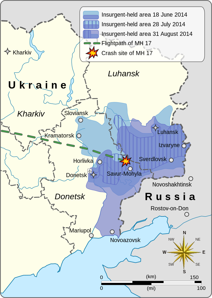
English: This is a map of the War in Donbass. It shows the expansion and contraction of pro-Russian insurgent-held areas over the duration of the conflict, starting with 18 June 2014, then as of 28 July, and finally as of 31 August. It also depicts the flightpath and crash-site of Malaysia Airlines Flight 17.
|
|||||||||||||||||
| 날짜 | ||||||||||||||||||
| 출처 |
다음을 기초로 한 자작: Europe laea location map.svg
|
|||||||||||||||||
| 저자 | Goran tek-en | |||||||||||||||||
| 저작권 (이 파일을 인용하기) |
이 파일은 크리에이티브 커먼즈 저작자표시-동일조건변경허락 4.0 국제 라이선스로 배포됩니다. 저작자표시: Goran tek-en
|
|||||||||||||||||
| 다른 버전 |
|
|||||||||||||||||
| SVG 발전 | ||||||||||||||||||


.svg)
| 대상 위치 | | 이 지역의 다른 사진을 보기: OpenStreetMap |
|---|


파일 역사
날짜/시간 링크를 클릭하면 해당 시간의 파일을 볼 수 있습니다.
| 날짜/시간 | 섬네일 | 크기 | 사용자 | 설명 | |
|---|---|---|---|---|---|
| 현재 | 2021년 12월 5일 (일) 19:11 | | 570 × 800 (79 KB) | Goran tek-en (토론 | 기여) | ppi to 96, optimized |
| 2015년 1월 15일 (목) 10:14 |  | 570 × 800 (140 KB) | Goran tek-en (토론 | 기여) | corrected spelling, corrected area of 31 August | |
| 2015년 1월 14일 (수) 04:50 |  | 570 × 800 (139 KB) | RGloucester (토론 | 기여) | Reverted to version as of 16:17, 24 November 2014 | |
| 2014년 11월 25일 (화) 02:10 |  | 570 × 800 (140 KB) | Mondolkiri1 (토론 | 기여) | Horlivka was never reconquered by the Ukrainian govt. If some correction shall be done about previous military positions, they should be around Lugansk, not Horlivks. | |
| 2014년 11월 24일 (월) 16:17 |  | 570 × 800 (139 KB) | Goran tek-en (토론 | 기여) | User created page with UploadWizard |
이 파일을 덮어쓸 수 없습니다.
이 파일을 사용하는 문서
다음 문서 3개가 이 파일을 사용하고 있습니다:
이 파일을 사용하고 있는 모든 위키의 문서 목록
다음 위키에서 이 파일을 사용하고 있습니다:
- bg.wikipedia.org에서 이 파일을 사용하고 있는 문서 목록
- da.wikipedia.org에서 이 파일을 사용하고 있는 문서 목록
- de.wikipedia.org에서 이 파일을 사용하고 있는 문서 목록
- el.wikipedia.org에서 이 파일을 사용하고 있는 문서 목록
- en.wikipedia.org에서 이 파일을 사용하고 있는 문서 목록
- et.wikipedia.org에서 이 파일을 사용하고 있는 문서 목록
- eu.wikipedia.org에서 이 파일을 사용하고 있는 문서 목록
- ga.wikipedia.org에서 이 파일을 사용하고 있는 문서 목록
- he.wikipedia.org에서 이 파일을 사용하고 있는 문서 목록
- id.wikipedia.org에서 이 파일을 사용하고 있는 문서 목록
- kk.wikipedia.org에서 이 파일을 사용하고 있는 문서 목록
- ko.wikipedia.org에서 이 파일을 사용하고 있는 문서 목록
- lv.wikipedia.org에서 이 파일을 사용하고 있는 문서 목록
- ro.wikipedia.org에서 이 파일을 사용하고 있는 문서 목록
- ru.wikipedia.org에서 이 파일을 사용하고 있는 문서 목록
- sc.wikipedia.org에서 이 파일을 사용하고 있는 문서 목록
- sk.wikipedia.org에서 이 파일을 사용하고 있는 문서 목록
- so.wikipedia.org에서 이 파일을 사용하고 있는 문서 목록
- sr.wikipedia.org에서 이 파일을 사용하고 있는 문서 목록