File:World Speed Limits.svg
Vai alla navigazione
Vai alla ricerca

Dimensioni di questa anteprima PNG per questo file SVG: 800 × 459 pixel. Altre risoluzioni: 320 × 184 pixel | 640 × 367 pixel | 1 024 × 587 pixel | 1 280 × 734 pixel | 2 560 × 1 469 pixel | 2 754 × 1 580 pixel.
File originale (file in formato SVG, dimensioni nominali 2 754 × 1 580 pixel, dimensione del file: 960 KB)
Didascalie
Didascalie
Aggiungi una brevissima spiegazione di ciò che questo file rappresenta
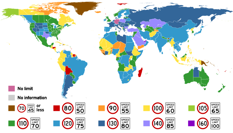
Speed limits around the world

|
Questa immagine è ritenuta la più recente che esista. Non esitate ad aggiornarla quando sia necessario.
|

|
Questo file può essere aggiornato per contenere nuove informazioni. Se si desidera utilizzare una versione specifica del file senza i nuovi aggiornamenti, è necessario caricare la versione richiesta in un file separato. |
Dettagli[modifica]
| Descrizione |
English: Highest posted speed limits around the world. In the key in the image, Vienna Convention standard signs indicate metric limits, and MUTCD standard signs indicate the equivalent imperial limits.
Español: Límites de velocidad máximos en los varios países del mundo. En varios casos, el límite indicado existe solamente en unos pocos tramos, y no por todo el país. En la leyenda, los señales europeos son métricos, y los señales estadounidenses utilizan unidades inglesas. Rosado indica velocidad ilimitada, y gris india una falta de información.
Français : Limites de vitesse maximales dans les pays du monde. Dans quelques cas, le limite indiqué existe seulement sur certains sections routiers, et pas partout le pays. Dans la légende, les panneaux européens sont métriques, et les panneaux américains utilisent des unités anglaises. Rose indique vitesse illimitée, et gris indique une manque d'information.
Italiano: I limiti di velocità più alti imposti per paese. Nella legenda i segnali secondo la Convenzione di Vienna indicano i limiti in km/h, e i segnali secondo lo standard statunitense (MUTCD) indicano il corrispondente valore in mph. |
| Data | |
| Fonte | Opera propria |
| Autore | Amateria1121 |
|
|
Questo file può essere aggiornato per contenere nuove informazioni. Se si desidera utilizzare una versione specifica del file senza i nuovi aggiornamenti, è necessario caricare la versione richiesta in un file separato. |
Licenza[modifica]
Io, detentore del copyright su quest'opera, dichiaro di pubblicarla con la seguente licenza:
Questo file è disponibile in base alla licenza Creative Commons Attribuzione-Condividi allo stesso modo 4.0 Internazionale
- Tu sei libero:
- di condividere – di copiare, distribuire e trasmettere quest'opera
- di modificare – di adattare l'opera
- Alle seguenti condizioni:
- attribuzione – Devi fornire i crediti appropriati, un collegamento alla licenza e indicare se sono state apportate modifiche. Puoi farlo in qualsiasi modo ragionevole, ma non in alcun modo che suggerisca che il licenziante approvi te o il tuo uso.
- condividi allo stesso modo – Se remixi, trasformi o sviluppi il materiale, devi distribuire i tuoi contributi in base alla stessa licenza o compatibile all'originale.
Cronologia del file
Fare clic su un gruppo data/ora per vedere il file come si presentava nel momento indicato.
| Data/Ora | Miniatura | Dimensioni | Utente | Commento | |
|---|---|---|---|---|---|
| attuale | 13:30, 22 gen 2024 | | 2 754 × 1 580 (960 KB) | Purin128AL (discussione | contributi) | Updated colour scheme, greenland speed |
| 09:22, 15 gen 2024 |  | 2 755 × 1 581 (949 KB) | Purin128AL (discussione | contributi) | Fix file dimensions | |
| 09:10, 15 gen 2024 |  | 512 × 294 (763 KB) | Purin128AL (discussione | contributi) | Update multiple countries | |
| 15:05, 30 giu 2022 |  | 512 × 294 (927 KB) | Ahmetlii (discussione | contributi) | Turkey: The maximum speed limit has been increased to 140 kmph, starting from July 1 | |
| 16:09, 27 giu 2021 |  | 512 × 294 (927 KB) | Purin128AL (discussione | contributi) | Fixed speed limit for San Marino, Vatican, Andorra, etc | |
| 15:37, 27 giu 2021 |  | 512 × 294 (945 KB) | Purin128AL (discussione | contributi) | Background is now not transparent | |
| 15:28, 27 giu 2021 |  | 512 × 286 (945 KB) | Purin128AL (discussione | contributi) | Removed empty white box in the middle, changed colours | |
| 15:26, 27 giu 2021 |  | 512 × 286 (945 KB) | Purin128AL (discussione | contributi) | Edied UAE speed limit, should be 160 instead of 140 | |
| 14:58, 29 set 2020 |  | 2 754 × 1 580 (1,43 MB) | Xtrela (discussione | contributi) | trying again | |
| 14:55, 29 set 2020 |  | 2 754 × 1 580 (1,55 MB) | Xtrela (discussione | contributi) | Reverted to version as of 07:20, 9 August 2020 (UTC) |
Impossibile sovrascrivere questo file.
Utilizzo del file
Le seguenti 65 pagine usano questo file:
- User:Chumwa/OgreBot/Potential transport maps/2016 November 21-30
- User:Chumwa/OgreBot/Potential transport maps/2017 August 21-31
- User:Chumwa/OgreBot/Potential transport maps/2017 February 1-9
- User:Chumwa/OgreBot/Potential transport maps/2017 January 1-10
- User:Chumwa/OgreBot/Potential transport maps/2017 January 21-31
- User:Chumwa/OgreBot/Potential transport maps/2017 May 1-10
- User:Chumwa/OgreBot/Potential transport maps/2017 May 21-31
- User:Chumwa/OgreBot/Potential transport maps/2017 November 1-10
- User:Chumwa/OgreBot/Potential transport maps/2017 September 1-10
- User:Chumwa/OgreBot/Potential transport maps/2018 May 1-10
- User:Chumwa/OgreBot/Potential transport maps/2019 April 11-20
- User:Chumwa/OgreBot/Potential transport maps/2019 February 1-9
- User:Chumwa/OgreBot/Potential transport maps/2019 July 1-10
- User:Chumwa/OgreBot/Potential transport maps/2019 March 21-31
- User:Chumwa/OgreBot/Potential transport maps/2019 October 11-20
- User:Chumwa/OgreBot/Transport Maps/2014 December 1-10
- User:Chumwa/OgreBot/Transport Maps/2015 April 1-10
- User:Chumwa/OgreBot/Transport Maps/2015 July 21-31
- User:Chumwa/OgreBot/Transport Maps/2015 June 21-30
- User:Chumwa/OgreBot/Transport Maps/2015 March 11-20
- User:Chumwa/OgreBot/Transport Maps/2015 May 11-20
- User:Chumwa/OgreBot/Transport Maps/2015 November 1-10
- User:Chumwa/OgreBot/Transport Maps/2015 October 1-10
- User:Chumwa/OgreBot/Transport Maps/2016 March 1-10
- User:Chumwa/OgreBot/Transport Maps/2016 November 21-30
- User:Chumwa/OgreBot/Transport Maps/2017 August 21-31
- User:Chumwa/OgreBot/Transport Maps/2017 February 1-9
- User:Chumwa/OgreBot/Transport Maps/2017 January 1-10
- User:Chumwa/OgreBot/Transport Maps/2017 January 21-31
- User:Chumwa/OgreBot/Transport Maps/2017 May 1-10
- User:Chumwa/OgreBot/Transport Maps/2017 May 21-31
- User:Chumwa/OgreBot/Transport Maps/2017 November 1-10
- User:Chumwa/OgreBot/Transport Maps/2017 September 1-10
- User:Chumwa/OgreBot/Transport Maps/2018 May 1-10
- User:Chumwa/OgreBot/Transport Maps/2019 April 11-20
- User:Chumwa/OgreBot/Transport Maps/2019 February 1-9
- User:Chumwa/OgreBot/Transport Maps/2019 July 1-10
- User:Chumwa/OgreBot/Transport Maps/2019 March 21-31
- User:Chumwa/OgreBot/Transport Maps/2019 October 11-20
- User:Chumwa/OgreBot/Transport Maps/2020 August 1-10
- User:Chumwa/OgreBot/Transport Maps/2020 July 1-10
- User:Chumwa/OgreBot/Transport Maps/2020 March 1-10
- User:Chumwa/OgreBot/Transport Maps/2020 March 21-31
- User:Chumwa/OgreBot/Transport Maps/2020 September 21-30
- User:Chumwa/OgreBot/Transport Maps/2021 June 21-30
- User:Chumwa/OgreBot/Transport Maps/2022 June 21-30
- User:Chumwa/OgreBot/Transport Maps/2024 January 11-20
- User:Chumwa/OgreBot/Transport Maps/2024 January 21-31
- User:Chumwa/OgreBot/Travel and communication maps/2016 March 1-10
- User:Chumwa/OgreBot/Travel and communication maps/2016 November 21-30
- User:Chumwa/OgreBot/Travel and communication maps/2017 August 21-31
- User:Chumwa/OgreBot/Travel and communication maps/2017 February 1-9
- User:Chumwa/OgreBot/Travel and communication maps/2017 January 1-10
- User:Chumwa/OgreBot/Travel and communication maps/2017 January 21-31
- User:Chumwa/OgreBot/Travel and communication maps/2017 May 1-10
- User:Chumwa/OgreBot/Travel and communication maps/2017 May 21-31
- User:Chumwa/OgreBot/Travel and communication maps/2017 November 1-10
- User:Chumwa/OgreBot/Travel and communication maps/2017 September 1-10
- User:Chumwa/OgreBot/Travel and communication maps/2018 May 1-10
- User:Chumwa/OgreBot/Travel and communication maps/2019 April 11-20
- User:Chumwa/OgreBot/Travel and communication maps/2019 February 1-9
- User:Chumwa/OgreBot/Travel and communication maps/2019 July 1-10
- User:Chumwa/OgreBot/Travel and communication maps/2019 March 21-31
- User:Chumwa/OgreBot/Travel and communication maps/2019 October 11-20
- Commons:Files used on the AARoads Wiki/73
Utilizzo globale del file
Anche i seguenti wiki usano questo file:
- Usato nelle seguenti pagine di cs.wikipedia.org:
- Usato nelle seguenti pagine di de.wikipedia.org:
- Usato nelle seguenti pagine di en.wikipedia.org:
- Usato nelle seguenti pagine di es.wikipedia.org:
- Usato nelle seguenti pagine di fi.wikipedia.org:
- Usato nelle seguenti pagine di fr.wikipedia.org:
- Usato nelle seguenti pagine di gl.wikipedia.org:
- Usato nelle seguenti pagine di it.wikipedia.org:
- Usato nelle seguenti pagine di ja.wikipedia.org:
- Usato nelle seguenti pagine di lmo.wikipedia.org:
- Usato nelle seguenti pagine di pl.wikipedia.org:
- Usato nelle seguenti pagine di simple.wikipedia.org:
- Usato nelle seguenti pagine di tr.wikipedia.org:
- Usato nelle seguenti pagine di uk.wikipedia.org:
- Usato nelle seguenti pagine di zh.wikipedia.org: