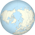
File:Worldmap northern.svg
跳转到导航
跳转到搜索

此SVG文件的PNG预览的大小:553 × 553像素。 其他分辨率:240 × 240像素 | 480 × 480像素 | 768 × 768像素 | 1,024 × 1,024像素 | 2,048 × 2,048像素。
原始文件 (SVG文件,尺寸为553 × 553像素,文件大小:589 KB)

原始文件 (SVG文件,尺寸为553 × 553像素,文件大小:589 KB)
| 描述Worldmap northern.svg |
English: A polar projection of the northern hemisphere, with national borders, from Image:Worldmap_location_NED_50m.svg. Created from Natural Earth Data using gringer's perlshaper script. |
| 日期 | |
| 来源 | 自己的作品 |
| 作者 | Gringer (talk) |
| 其他版本 | 此文件衍生的作品: Muskox distribution combined.png |
| Public domainPublic domainfalsefalse |
| 我,本作品著作权人,释出本作品至公有领域。这适用于全世界。 在一些国家这可能不合法;如果是这样的话,那么: 我无条件地授予任何人以任何目的使用本作品的权利,除非这些条件是法律规定所必需的。 |
点击某个日期/时间查看对应时刻的文件。
| 日期/时间 | 缩略图 | 大小 | 用户 | 备注 | |
|---|---|---|---|---|---|
| 当前 | 2013年5月1日 (三) 12:34 |  | 553 × 553(589 KB) | Gringer(留言 | 贡献) | updated script -- proper group ordering |
| 2013年4月29日 (一) 01:03 |  | 552 × 552(465 KB) | Gringer(留言 | 贡献) | Updated perlshaper script | |
| 2010年9月3日 (五) 10:31 |  | 550 × 550(563 KB) | Gringer(留言 | 贡献) | Updated using [http://www.naturalearthdata.com Natural Earth Data]. | |
| 2009年2月13日 (五) 01:17 |  | 181 × 181(308 KB) | Gringer(留言 | 贡献) | increase in ocean size to make border sit mostly outside land | |
| 2009年2月13日 (五) 01:10 |  | 180 × 180(308 KB) | Gringer(留言 | 贡献) | {{Information |Description={{en|1=A polar projection of the northern hemisphere from Image:Worldmap_wdb_combined.svg. Created from [http://www.evl.uic.edu/pape/data/WDB/ CIA World Databank data] using an updated version of my [http://user.interface.o |
您不可以覆盖此文件。
以下页面使用本文件:
以下其他wiki使用此文件:
此文件含有额外信息,这些信息可能是创建或数字化该文件时使用的数码相机或扫描仪所添加的。如果文件已从其原始状态修改,某些详细信息可能无法完全反映修改后的文件。
| 宽度 | 553 |
|---|---|
| 高度 | 553 |