Namibia
ナビゲーションに移動
検索に移動
アフリカ南部の国    .svg) | |||||
| メディアをアップロード | |||||
| 話し言葉の音声 | |||||
|---|---|---|---|---|---|
| 発音音声 | |||||
| 分類 | |||||
| 以下の一部分 |
| ||||
| 名前の由来 | |||||
| 文化 | |||||
| 場所 |
| ||||
| 隣接・位置する水域 | |||||
| 行政中心地 | |||||
| 立法府 | |||||
| 行政府 | |||||
| 公用語 | |||||
| アンセム |
| ||||
| 通貨 | |||||
| 元首 |
| ||||
| 行政府の長 | |||||
| 成立日 |
| ||||
| 最も高い地点 | |||||
| 人口 |
| ||||
| 面積 |
| ||||
| 先行 | |||||
| トップレベルドメイン | |||||
| 公式ウェブサイト | |||||
 | |||||
ナミビア共和国、通称ナミビアは、アフリカ南西部に位置する共和制国家である。北にアンゴラ、北東にザンビア、東にボツワナ、南に南アフリカ共和国と国境を接し、西は大西洋に面する。首都はウィントフック。
国の象徴[編集]
メインカテゴリー: Symbols of Namibia


国立公園[編集]
メインカテゴリー: National parks of Namibia, および animals of Namibia
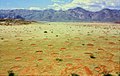
ナミブ=ナウクルフト国立公園[編集]
 location in Namibia (#11)
|
メインギャラリー: Namib-Naukluft National Park.
-
 Namib Rand Nature Reserve
 -
 Red Namib sand dune
 -
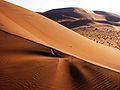 Namib Desert
 -

-
-
 Neckartaldamm
 -


.jpg)


.jpg)
.jpg)
ソーサスフライ[編集]
メインギャラリー: Sossusvlei.
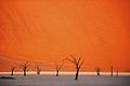
-
 Oceanic fog near Sossusvlei
 -
 Road to Sossusvlei
 -
 Sossusvlei Dune
 -

-


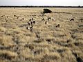
動物[編集]

.jpg)

エトーシャ国立公園[編集]
location in Namibia (#5)
|
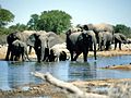
メインギャラリー: Etosha National Park.
-
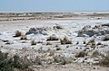
 Etosha pan
 -
-
-
-
 Fort Namutoni


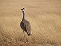
動物[編集]
-

-

-
-

-

-
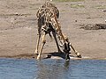 trinkende Giraffe im Etosha Nationalpark
 -
 Dreibandregenpfeifer im Etosha Nationalpark


.jpg)

.jpg)


Sperrgebiet[編集]
location in Namibia (#19)
|
メインカテゴリー: Sperrgebiet


.jpg)
リューデリッツ[編集]
メインギャラリー: Lüderitz.
-
 Diaz Point
 -
 Große Bucht
 -
 Halifax Island
 -
 Mercury Island


.jpg)
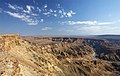
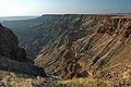
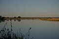
フィッシュ川渓谷[編集]
location in Namibia (#1)
|
メインギャラリー: Fish River Canyon.
-

-
-
-
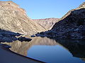 river bed of the Fish River


スケルトン海岸国立公園[編集]
location in Namibia (#3)
|
メインカテゴリー: Skeleton Coast


世界遺産[編集]
メインカテゴリー: World Heritage Sites in Namibia
トゥウェイフルフォンテーン[編集]
 location in Namibia
|
メインギャラリー: Twyfelfontein.
-
 Lion Petroglyph
 -
 Rock Painting/ Felsmalerei
 -
 San rock art/ San-Felskunst
 -
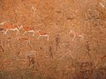 Weiße Dame
 -
 Dancing Kudu


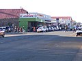
都市、町および;村落[編集]
主なカテゴリー: cities in Namibia および villages in Namibia
-
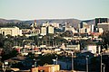
ウィントフック
(首都) -
-
-

-
 Namibia - Otjikandero Himba Orphan Village - Photo taken in october 2015
 -
 Koës
Koës -
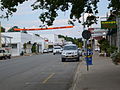
 Henties bay


.jpg)

ナミビアの行政区画[編集]
メインカテゴリー: regions of Namibia
カプリビ州[編集]
メインギャラリー: Caprivi.
-
 map of Caprivi
 -
カティマ・ムリロ
(首都) -
 Driving on the Trans-Caprivi Corridor
 -
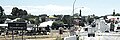
 a Village in the caprivi flood plain/ein Dorf im Überschmemmungsgebiet des Zambesi
 -


エロンゴ州[編集]
メインギャラリー: Erongo.
-
 map of Erongo
 -

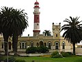
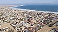
スワコプムント
(首都) -
 Dune bashing near Swakopmund
 -

-
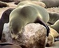
 Cape Cross Seal Colony/ Kreuzkap-Seebärenkolonie
 -

.jpg)
.jpg)


ハルダプ州[編集]
メインギャラリー: Hardap.
-
 map of Hardap
 -
マリエンタール
(首都) -
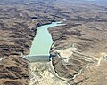
 Hardap dam
 -
 Gamsberg
 -


カラス州[編集]
メインギャラリー: Karas.
-
 map of Karas
 -

ケートマンスフープ
(首都) -

-

-

-


東カバンゴ州[編集]
メインギャラリー: Kavango.
-
 map of Kavango
 -

ルンドゥ
(首都) -
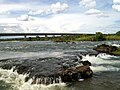
 Popa Falls
 -
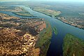
 Okavango river at Utokota
 -
 Okavango river at Rundu


ホマス州[編集]
メインギャラリー: Khomas.
-
 map of Khomas
 -

ウィントフック
(首都) -
 HESS telescopes/ HESS-Teleskope


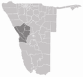
クネネ州[編集]
メインギャラリー: Kunene.
-
 map of Kunene
 -

オプウォ
(首都) -
 Kunene river
 -
 Ruacana Falls
 -
 Himba village
 -
 Grootberg
 -
 Fairy circles/ Feenkreise und Hartmannberge

.jpg)


オハングウェナ州[編集]
メインギャラリー: Ohangwena.
-
 map of Ohangwena
 -
エーンハナ
(首都)


オマヘケ州[編集]
メインギャラリー: Omaheke.
-
 map of Omaheke
 -

ゴバビス
(首都) -


オムサティ州[編集]
メインギャラリー: Omusati.
-
 map of Omusati
 -

アウタピ
(首都)


オシャナ州[編集]
メインギャラリー: Oshana.
-
 map of Oshana
 -
オシャカティ
(首都) -
 Der 1976 errichtete Sendemast (275 Meter hoch) im Zentrum von Oshakati
 -
 Dr. Frans Aupa Indongo Open Market in Oshakati, am 11.3.2016 eroeffnet
 -
 Der 48 Meter hohe Aussichtsturm Oshungo ya Shakati am neuen Markt von Oshakati
 -
 Efundia, Oshana


オシコト州[編集]
メインギャラリー: Oshikoto.
-
 map of Oshikoto
 -

オムシーヤ
(首都) -


オチョソンデュパ州[編集]
メインギャラリー: Otjozondjupa.
-
 map of Otjozondjupa
 -
オティワロンゴ
(首都) -

-
 Cheetah Conservation Fund in Otjiwarongo


衛星画像[編集]
メインカテゴリー: Satellite pictures of Namibia
-
 NASA's Long Duration Exposure Facility during a photographic survey above the town of Lüderitz
 -
 Fish River Canyon, Huns-berge from LandSat 7
 -
 Sossusvlei, Namib desert from LandSat 7
 -
 Walvis Bay, Erongo from LandSat 7
 -
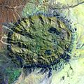 Brandberg, Erongo from LandSat 7


政治[編集]
メインカテゴリー: Politics of Namibia
-

-

-

サム・ヌジョマ
共和国大統領 1990年と2005年の間 -

ヒフィケプニェ・ポハンバ
共和国大統領 2005年と2015年の間 -

ナハス・アングラ
ナミビアの首相 2005年と2012年の間 -

ヘイジ・ガインゴブ
共和国大統領 2015年と現在の間 -

サーラ・クーゴンゲルワ=アマディラ
ナミビアの首相 2015年と現在の間


.jpg)
スポーツ[編集]
メインカテゴリー: Sports in Namibia

