Panama Canal
ナビゲーションに移動
検索に移動

パナマ共和国の国際運河   | |||||
| メディアをアップロード | |||||
| 話し言葉の音声 | |||||
|---|---|---|---|---|---|
| 分類 | |||||
| 以下の一部分 |
| ||||
| 場所 | |||||
| 以下と接続 | |||||
| 依頼者 |
| ||||
| 以下を含む | |||||
| 出発地 |
| ||||
| 目的地 |
| ||||
| 遺産保護指定 | |||||
| 公式開始日 |
| ||||
| 全長 |
| ||||
| 標高 |
| ||||
 | |||||
The Panama Canal is a large canal, 51 miles (82 kilometers) long, that cuts through the isthmus of Panama, connecting the Atlantic and Pacific oceans.
Views
[編集]-
 English: SS Kroonland transits the Panama Canal on 2 February 1915. She was the largest passenger ship to that date to transit the canal
 -
 English: Bridge of the Americas.Español: Puente de las Américas
 -
 English: Miraflores Locks.Español: Esclusas de Miraflores
 -
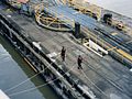
 English: A "mule"
 -
-

-
 English: Watching the clearance
 -
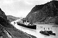
 English: approaching Gaillard Cut
 -
 English: Gaillard Cut
 -
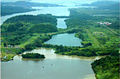
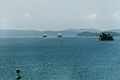 Español: Lago GatúnEnglish: Gatun Lake, pictured here in 2000, is having difficulty supplying water for the canal's operation.Français : Les navires suivent un chenal balisé entre les îles.
 -
 English: Gatun Locks.Español: Esclusas de Gatún
 -
 English: Gatun Locks.Español: Apertura de las esclusas de Gatún
 -

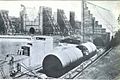
 English: The Thor is a drilling and blasting barge used to deepen and widen the main ship route of the Canal.
 -
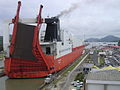 English: Picture of a ship at the Miraflores Locks of the Panama Canal
 -

-
 Svenska: Panamakanalens huvudkontor ligger i Balboa, Panama.
 -
 Lëtzebuergesch: Eng Schleis vum Pananamakanal
 -
 English: The 'Puente de las Americas', crossing the Panamá Canal to the North of Panamá City, ssen from the foot of Cerro Ancón.
 -
 Deutsch: Sicht vom Cerro Ancón (Panama City) auf den Panamakanal
 -
 Panamax ship crossing the Miraflores Locks
 -
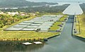
 Aerial view of the Miraflores (center bottom) and Cocolí (center top) locks
 -
 New Agua Clara locks in the Atlantic side
 -
 Neopanamax ship crossing the new Agua Clara locks
 -
 Control Tower of the new Agua Clara locks
 -
 Bridge of the Americas


1904-1914 Construction
[編集]-
 English: Pedro Miguel Locks under construction at the Panama Canal
 -
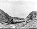
 English: The famous Culebra Cut, Panama Canal, 1907
 -
 English: Construction of Panama Canal, Isthmian Historical Society, ca1913
 -
 Français : Le mur central des écluses de Gatún pendant sa construction en 1910. L'homme debout en bas à droite illustre sa taille.
 -
 Français : Les principaux moules à l'avant-plan pendant la construction : à l'arrière, les moules des murs.
 -
 Čeština: Práce na Culebra Cut v prosinci 1904
 -
 English: Work on lock, Panama Canal, November 1910
 -
 failed design


1939-1940 Excavation
[編集]-
 English: 1939 Excavation.

2007-2016 Expansion
[編集]-
 English: Dredging of Atlantic Navigation Access Channel
 -
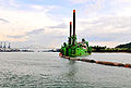 English: Breydel Dredge at the south Access Channel in the Pacific entrance
 -
 English: Aereal view of the Pacific Construction Site
 -
 English: Pacific Construction Site of the Third Set of Locks - Progress as of Feb 2010.
 -
 English: Pacific Construction Site of the Third Set of Locks (Cocolí locks) - Progress as of July 2015.


conceptual views
[編集]-
 English: Filling and Empting System for the Third Set of Locks
 -
 English: Conceptual view of the Third Set of Locks
 -
 English: Conceptual view of the Third Set of Locks
 -
 English: Conceptual view of the Third Set of Locks
 -
 English: Conceptual view of the Third Set of Locks
 -
 English: Conceptual view of the Third Set of Locks


Maps
[編集]-
 English: Map of the Panama Canal
 -
 English: Map of Panama with the Canal
 -
 English: Panama Canal, courtesy NASA
 -
 English: The Panama Canal Zone
 -
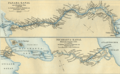
 English: This elevation map of the Panama Canal, prepared in 1923, shows the topography of the region through which the canal was cut.
 -
Deutsch: Historische Karte des Panamakanals und des Nicaragua-Kanals
-
 Čeština: Goethalsova mapa Gatunské pr(ehrady
 -
 Español: Tráfico por el Canal de Panamá (años 1980 - 2005, texto en francés).
 -
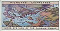 birdseye diagram


