<nowiki>Sopot; Sopot; Sopot; Sopot; Сопот; Sopot; Sopot; Sopot; 索波特; Sopot; 소포트; Sopot; Sopoty; Sopot; Sopot; Sopòt; Sopot; Sopot; Sopot (Poljska); Sopot; Sopot; Sopot; Sopota; Sopot; Сопот; Sopot; Sopot; Sopot; Sopot; Sopot; Sopot; Sopot; سوبوت; 索璞特; Sopot; Sopot; Sopot; Сопот; Sopot; Сопот; Сопат; Սոպոտ; 索波特; Sopot; სოპოტი; ソポト; سوبوت; Sopot; סופוט; Сопот; 索波特; Sopot; Sopot; Sopot; Sopot; Sopot; Sopot; Sopot; Сопат; Sopot; Sopot; Сопот; Sopot; Sopotas; Sopot; سوپوت; Sopot; Sopot; Sopot; Sopot; Sopot, Polandia; Sopot; Sopot; Сопот; سوپوت; Сопот (Польш); Sopot; Sopot; Σόποτ; სოპოტი; ciudad de Polonia; város Lengyelországban; ciutat de Polònia; tref glan-môr, ar arfordir Môr y Baltig, Gwlad Pwyl; qytet në Poloni; քաղաք Լեհաստանում; град в Полша; oraș din Polonia de astăzi; ポーランドの都市; مدينه فى محافظه بوميرانيا; місто на правах повіту Польщі; Пүлшә шәһәре; urbo en nuntempa Pollando; град во Полска; città della Polonia; station balnéaire au nord de la voïvodie de Poméranie; linn Poolas Pomorze vojevoodkonnas; baile sa Pholainn; město w Pólskej; cidade na atual Polônia; raħal fil-Polonja; ნოღა პომერანიაშ სავოევოდეს, პოლონეთი; горад у Польшчы; град у Пољској; Ostseebad im Ballungsraum Danzig, Polen; miestas dabartinės Lenkijos teritorijoje; cidade com direitos de condado no norte da Polônia, na voivodia da Pomerânia; город в Польше, Поморское воеводство; munisipyo; miasto w województwie pomorskim; by i nordlige Polen; stad in het hedendaagse Polen; עיירת נופש בפולין; места ў Паморскім ваяводзтве Польшчы; sídlo v Pomořském vojvodství v Polsku; pilsēta mūsdienu Polijā; town in Poland; stad i dagens Polen; 波兰城镇; ქალაქი პომერანიის სავოევოდოში, პოლონეთში; Sopot İlçesi; Sopot ilçesi; Sopoto; Zoppot; Zoppot</nowiki>
Q92689 VIAF-identificatiecode: 124302254 GND-identificatiecode: 4079533-0 LCAuth-identificatiecode: n50013319 NKC-identificatiecode: ge130893 JGU-identificatiecode van de Nationale Bibliotheek van Israël: 987007554828405171 OpenStreetMap-identificatiecode voor knoop: 31530688
Pier in Sopot, longest wooden pier in Europe - 450 meter from bank, 650 whole
Saint George Church.Kościół Św. Jerzego.
Latarnia morska.
beach and pier
Mainstreet
Kathedraal
Train station
Pomnik AK
Krzywy Domek
Fontanna
Krzywy Domek
Coastline
molo widok z latarni morskiej
kutry przy sopockiej plaży
latarnia morska w Sopocie
Molo w Sopocie
Plaża w Sopocie
Molo w Sopocie
Pomnik AK w Sopocie
Zakład balneologiczny w Sopocie
Dit is een galerijpagina met speciaal geselecteerde afbeeldingen en andere media bestanden. Ze zijn gekozen als hoogtepunten van een specifiek onderwerp, maar vertegenwoordigen niet het volledige scala aan bestanden dat beschikbaar is op Commons. Zie Category:Sopot, Poland voor een bredere selectie van bestanden die zijn verbonden met Sopot, Poland.


 the longest wooden pier in Europe
 Pier in Sopot, longest wooden pier in Europe - 450 meter from bank, 650 whole
 Saint George Church.Kościół Św. Jerzego.
 Latarnia morska.
 beach and pier
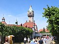

 Mainstreet
 Kathedraal
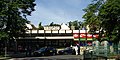 Train station
 Pomnik AK
 Krzywy Domek
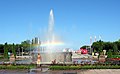
 Fontanna
 Krzywy Domek
 Coastline
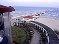 molo widok z latarni morskiej
 kutry przy sopockiej plaży
 latarnia morska w Sopocie
 Molo w Sopocie
 Plaża w Sopocie
 Molo w Sopocie
 Pomnik AK w Sopocie
 Zakład balneologiczny w Sopocie


.jpg)


.jpg)


.JPG)
