Hansestaden Visby
(重定向自Visby)
| 相机位置 | | 所有坐标的地图 - OpenStreetMap |
|---|
English: The Hanseatic town Visby is the description of Visby, Sweden, from the UNESCO World Heritage Committee.
Visby was founded in the 10th century, on the then independent Baltic Sea island of Gotland. The Hansaetic League formed it during ensuing centuries, during which it came to Denmark. In 1645, it came into Swedish occupation, in which it has remained until today.
town of the Hanseatic League in Sweden  | |||||
| 上传媒体 | |||||
| 隶属于 | |||||
|---|---|---|---|---|---|
| 位置 | 维斯比, 哥得兰市镇, 哥得兰省, 瑞典 | ||||
| 可分为 | |||||
| 文化遗产保护状况 |
| ||||
| 相异物 | |||||
 | |||||
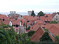
Photos[编辑]
-
 Panorama
 -
 satellite image
 -
 The harbor
 -
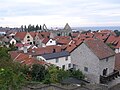
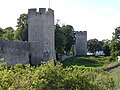
 City walls
 -
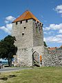 A tower in the wall
 -
 Strandpromenaden
 -
 Almedalen
 -
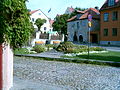
 Fishermans Alley
 -
 Packhusplan square
 -
 Street
 -
 Drotten Church
 -
 Helgeand Church
 -
 St Clemens Church
 -
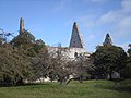
 St Lars Church
 -
 St Olof Church
 -
 St Per and St Hans
 -
 St Gertrud Chapel
 -
 St George Church
 -
 Model of Visborg Castle
 -
-

-

-

-

-

-

-

-

-

-
-

-

-

-


.jpg)


