Category:Girraween National Park
parc national du Queensland (Australie)  | |||||
| Téléverser des médias | |||||
| Nature de l’élément | |||||
|---|---|---|---|---|---|
| Lieu | Queensland, Australie | ||||
| Opérateur |
| ||||
| Catégorie des aires protégées de l'UICN | |||||
| Date de fondation ou de création |
| ||||
| Superficie |
| ||||
| site officiel | |||||
 | |||||
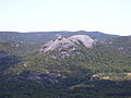
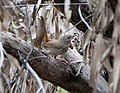
Girraween National Park is an area of the Granite Belt] in the Darling Downs region of Queensland, Australia reserved as a national park. Girraween is known for its spectacular flowers, dramatic landscapes and unique wildlife. The park is situated 40 km south of Stanthorpe. The southern boundary of the park is the state border between Queensland and New South Wales. It is a twin park with Bald Rock National Park, which lies across the border in New South Wales, and features Bald Rock, the second-largest monolith (after Uluru) on the continent. Curiously, South Bald Rock and West Bald Rock lie in Girraween National Park in Queensland, not in Bald Rock National Park in New South Wales.
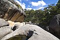
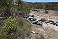
It features granite landscapes, balancing boulders, clear streams, wetlands, cascades and open forest. The granite outcroppings, such as the Pyramids and Castle Rock at 1112 m, dominate the local scenery. The park contains many kilometres of graded walking trails to the park's major features like the First Pyramid, Second Pyramid, The Sphinx, Turtle Rock, Underground Creek, the Eye of the Needle and Mount Norman - the highest point in the park at 1267 metres. Fire trails can be followed when venturing into the southern and eastern sections of the park. The park has a temperate climate. During winter snow can fall in the area.
Sous-catégories
Cette catégorie comprend 9 sous-catégories, dont les 9 ci-dessous.
Média dans la catégorie « Girraween National Park »
Cette catégorie comprend 68 fichiers, dont les 68 ci-dessous.
-
 1 Girraween National Park 1.jpg 4 047 × 792 ; 561 kio
-
 1 Girraween National Park 2.jpg 3 116 × 812 ; 617 kio
-
 1 Girraween National Park 3.jpg 6 841 × 761 ; 1,35 Mio
-
 1 Girraween National Park 4.JPG 2 304 × 1 728 ; 1,02 Mio
-
 Actinotus gibbonsii halfway to summit of Mt Norman P2152352.jpg 4 000 × 3 000 ; 2,5 Mio
-
 At the foot of Pyramid. Girraween National Park (22318387102).jpg 1 600 × 1 067 ; 929 kio
-
 Balancing rock (24077399154).jpg 1 200 × 900 ; 670 kio
-
 Balancing Rock - panoramio.jpg 1 920 × 2 560 ; 2,59 Mio
-
 Black butts Girraween National Park yarra64.jpg 2 048 × 1 365 ; 560 kio
-
 Chestnut- Rumped Heathwren small fx.jpg 4 013 × 3 110 ; 3,38 Mio
-
 Daviesia latifolia - Bitter Pea, Hop Bitter-pea (21764456673).jpg 900 × 1 200 ; 373 kio
-
 Daviesia latifolia - Bitter Pea, Hop Bitter-pea (22396340461).jpg 1 355 × 900 ; 360 kio
-
 Dotted Sun Orchid (21764509293).jpg 900 × 1 200 ; 209 kio
-
 Flowers of Girraween (22198743939).jpg 1 354 × 900 ; 763 kio
-
 Giraween National Park - Balancing Rock - I got it 2.jpg 2 592 × 3 872 ; 6,9 Mio
-
 Giraween National Park - Balancing Rock - I got it.jpg 990 × 2 539 ; 2,42 Mio
-
 Giraween National Park - Hiking the Pyramid.jpg 2 731 × 1 913 ; 2,94 Mio
-
 Giraween National Park - The Pyramids.jpg 2 592 × 1 168 ; 2,16 Mio
-
 Giraween National Park QLD.jpg 3 072 × 4 608 ; 3,98 Mio
-
 Giraween National Park.jpg 3 872 × 2 592 ; 2,23 Mio
-
 Giraween Panorama2a.jpg 7 054 × 2 405 ; 8,47 Mio
-
 Girraween - Granite Arch.jpg 768 × 1 024 ; 483 kio
-
 Girraween Nat Pk Qld.jpg 4 992 × 3 285 ; 3,95 Mio
-
 Girraween National Park (30958137894).jpg 8 872 × 3 016 ; 9,29 Mio
-
 Girraween National Park (31651497482).jpg 8 533 × 2 390 ; 6,82 Mio
-
 Girraween National Park Pyramid 9.jpg 1 024 × 683 ; 284 kio
-
 Girraween National Park, from mt. Norman (22143624508).jpg 1 600 × 1 067 ; 707 kio
-
 Girraween NP.jpg 2 048 × 1 152 ; 972 kio
-
 Girraween rocks (22174666554).jpg 1 600 × 1 067 ; 671 kio
-
 Girraween rocks (22379028058).jpg 1 600 × 1 063 ; 756 kio
-
 Girraween, climbing The Pyramids (5703100397).jpg 1 024 × 680 ; 322 kio
-
 Girraween, view from The Pyramids (5703669018).jpg 1 024 × 680 ; 297 kio
-
 Google Street View Car in Girraween.jpg 1 280 × 842 ; 304 kio
-
 Granite Arch, Girraween National Park, Australia (5741598940).jpg 1 028 × 684 ; 449 kio
-
 Granite escarpment and woodland Girraween National Park Wyberba Queensland 1980s IMG 0062 (3).jpg 6 400 × 4 329 ; 16,32 Mio
-
 Granite escarpment and woodland Girraween National Park Wyberba Queensland 1980s IMG 0066 (3).jpg 6 400 × 4 325 ; 36,16 Mio
-
 Granite heather - Micromyrtus sessilis (22372499102).jpg 1 350 × 900 ; 590 kio
-
 Granite hill Girraween National Park Wyberba Queensland 1980s IMG 0021 (4).jpg 6 390 × 4 325 ; 22,31 Mio
-
 Granite tor Girraween National Park Wyberba Queensland IMGP3627.jpg 3 008 × 2 000 ; 3,26 Mio
-
 Granite tor Girraween National Park Wyberba Queensland IMGP3628.jpg 3 008 × 2 000 ; 2,88 Mio
-
 Granite tor Girraween National Park Wyberba Queensland IMGP3629.jpg 3 008 × 2 000 ; 2,79 Mio
-
 Granite tor Girraween National Park Wyberba Queensland IMGP7947.jpg 3 008 × 2 000 ; 3,17 Mio
-
 Grevillea viridiflava.jpg 1 029 × 1 006 ; 130 kio
-
 John at Bald Rock Creek Girraween National Park Wyberba Queensland 1980s IMG 0007.jpg 4 256 × 6 432 ; 16,71 Mio
-
 John Girraween National Park Wyberba Queensland 1980s IMG 0078.jpg 4 326 × 6 453 ; 26,37 Mio
-
 John Girraween National Park Wyberba Queensland 1980s IMG 0079.jpg 6 448 × 4 359 ; 21,16 Mio
-
 John Girraween National Park Wyberba Queensland 1980s IMG 0081.jpg 4 288 × 6 480 ; 21,38 Mio
-
 John Girraween National Park Wyberba Queensland 1980s IMG 0082.jpg 4 326 × 6 412 ; 30,33 Mio
-
 John Girraween National Park Wyberba Queensland 1990s IMG 0037 (2).jpg 4 386 × 6 448 ; 22,84 Mio
-
 John Girraween National Park Wyberba Queensland 1990s IMG 0038 (2).jpg 6 431 × 4 250 ; 28,85 Mio
-
 John in open forest Girraween National Park Wyberba Queensland 1990s IMG 0046.jpg 6 417 × 4 318 ; 33,31 Mio
-
 Kunzea obovata in Girraween (22372488162).jpg 1 350 × 900 ; 817 kio
-
 Linear-leaf Grevillea habitat (Grevillea viridiflava) in Girraween (22623495565).jpg 1 600 × 1 067 ; 1 001 kio
-
 Mushroom Girraween National Park Wyberba Qld IMG 0005.jpg 6 400 × 4 304 ; 6,06 Mio
-
 Mushroom Girraween National Park Wyberba Qld IMG 0012.jpg 6 896 × 4 304 ; 5,5 Mio
-
 Mushroom Girraween National Park Wyberba Qld IMG 0017 (2).jpg 4 368 × 7 040 ; 6,57 Mio
-
 Phebalium whitei, habitat (22372454982).jpg 1 354 × 900 ; 869 kio
-
 Prostanthera saxicola - Tatters.jpg 1 093 × 820 ; 141 kio
-
 Stanthorpe from Mount Marley lookout (7597351814).jpg 1 024 × 680 ; 367 kio
-
 Stockwell family Girraween National Park Wyberba Queensland 1980s IMG 0083 (2).jpg 6 416 × 4 352 ; 16,13 Mio
-
 The Junction - Girraween National Park QLD (48696901712).jpg 10 895 × 4 430 ; 54,47 Mio
-
 Two Pyramids. Girraween National Park (22143327410).jpg 1 600 × 1 067 ; 788 kio
-
 View from Mt Norman, Girraween National Park (22143334810).jpg 1 600 × 1 063 ; 804 kio
-
 View from the Pyramid. Girraween National Park (22143636418).jpg 1 200 × 1 200 ; 574 kio
-
 Vistagirrahween email.jpg 878 × 577 ; 160 kio
-
 Walking down from mt. Norman, Girraween National Park (22318362772).jpg 1 600 × 1 063 ; 836 kio
-
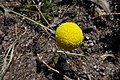 Yellow Billy buttons (Craspedia uniflora) (21764517673).jpg 1 350 × 900 ; 322 kio
-
 Гномики (Gnomes among the boulders) (5741046727).jpg 604 × 804 ; 255 kio


.jpg)
.jpg)


.jpg)
.jpg)
.jpg)
.jpg)


.jpg)

.jpg)
.jpg)
.jpg)
.jpg)

.jpg)
.jpg)
.jpg)
.jpg)
.jpg)


.jpg)
.jpg)

.jpg)
_in_Girraween_(22623495565).jpg)


.jpg)
.jpg)

.jpg)
.jpg)
.jpg)
.jpg)
.jpg)
.jpg)
_(21764517673).jpg)
_(5741046727).jpg)
.jpg)
.jpg)
.jpg)