Cape Town
Hopp til navigering
Hopp til søk
Afrikaans: Kaapstad is saam met Pretoria (die setel van die regering) en Bloemfontein (die geregtelike hoofstad) een van die drie hoofstede van die Republiek van Suid-Afrika en setel van die parlement.
Dansk: Kapstaden ved Kap Det Gode Håb er er den tredjestørste by i Sydafrika med knapt 3 millioner indbyggere.
Deutsch: Kapstadt ist nach Johannesburg und Durban die drittgrößte Stadt Südafrikas.
English: Cape Town is the second most populous city in South Africa. It is the provincial capital of the Western Cape, as well as the legislative capital of the country.
Nederlands: Kaapstad is samen met Pretoria (de zetel van de regering) en Bloemfontein (de gerechtelijke hoofdstad) een van de drie hoofdsteden van de Republiek van Zuid-Afrika en zetel van het parlement.
Svenska: Kapstaden är Sydafrikas näst största storstadsområde (efter Johannesburg), med 3,5 miljoner invånare i storstadskommunen
日本語: 南アフリカ共和国の都市ケープタウン。南アフリカで2番目に人口が多く、西ケープ州の州都であり、同時に南アフリカの首都である。
en av Sør-Afrikas tre hovedsteder        | |||||
| Last opp mediefiler | |||||
| Forekomst av |
| ||||
|---|---|---|---|---|---|
| Del av | |||||
| Oppkalt etter | |||||
| Plassering | City of Cape Town, Wes-Kaap, Sør-Afrika | ||||
| Tilgrensende vannmasse | |||||
| Øverste politiske forvaltningsleder |
| ||||
| Opptrer i |
| ||||
| Dato for etablering, fremstilling e.l. |
| ||||
| Folketall |
| ||||
| Areal |
| ||||
| Høyde over havet |
| ||||
| Angivelig det samme som | City of Cape Town | ||||
| offisielt nettsted | |||||
 | |||||
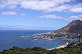
Views and skylines[rediger]
-
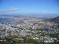
 View towards Cape Town from Robben Island
 -
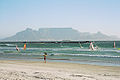 View from Bloubergstrand
 -
 table mountain
 -
 View of Camps Bay from Table Mountain
 -
 view
view -
 Khayelitsha


.jpg)


City Bowl[rediger]
-
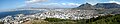
 City Bowl seen from Table Mountain
 -
 Central Cape Town seen from Lion's Head
 -
 Another view from Lion's Head
 -
 View of the City Bowl from Lions Head
 -
 View over the City Bowl towards the Northern Suburbs
 -
 A 360° panorama from Devil's Peak
 -
 Panoramic view of the City Bowl from Lion's Head
 -
 CBD skyline from the approach along Eastern Boulevard


Maps and satellite images[rediger]
-
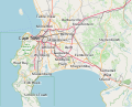 Street map of greater Cape Town
 -
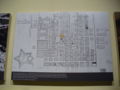
 Street map of the City Bowl
 -
 Location of the City of Cape Town in the Western Cape
 -
 Plan of Cape Town in 1798
 -
 Cape Town and Table Bay (1882)
 -
 Cape Peninsula (1890s)
 -
 Satellite image superimposed on elevation data
 -
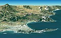
 Image from SPOT satellite
 -
 Population density
 -
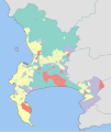
 Dominant languages
 -
 Dominant population groups
 -
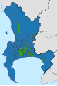 Proportional representation ballot results in the 2006 local elections
 -
 Ward councillor ballot results in the 2011 local elections


.svg)


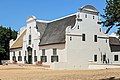
Architecture[rediger]
-
 Jameson Hall, the University of Cape Town's well-known landmark
 -
 Canal Walk Mall, Century City, Cape Town
 -

-
 Entrance CT Castle
 -

-


City Hall[rediger]
Supertech CapeTown archive copy at the Wayback Machine

Churches[rediger]
-
 at south end of Long St
 -
 St. George's Cathedral, Wale St.


Squares and parks[rediger]
Streets[rediger]
-
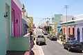 English: Bo-Kaap city street
 -
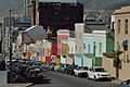 English: Bo-Kaap city street
 -
 English: Bo-Kaap city street
 -
 English: Bo-Kaap city street


Train station[rediger]
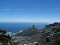
Mountain views[rediger]
-
 Afrikaans: TafelbergEnglish: Table Mountain
 -
 Afrikaans: DuiwelspiekEnglish: Devil's Peak
 -
 Afrikaans: LeeukopEnglish: Lion's Head


Harbour, beaches and seafront[rediger]
-
 Camps Bay
 -
 Waterfront harbor
 -
 Hout Bay harbor
 -
 Simonstown harbor.
 -
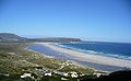 Long Beach
 -
 Kalk Bay Harbor


Victoria & Alfred Waterfront[rediger]
-
 View across the Victoria Basin
 -
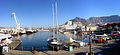 View across the Victoria Basin
 -
 Nedbank/BOE building at night


Kirstenbosch Botanical Gardens[rediger]
-
 Castle Rock
 -
 Tree ferns at "The Dell"
 -
 Tree aloe
 -
 World's longest leaves
 -
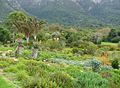 View from the aloe garden


Cape Peninsula[rediger]
-
 African Penguins at Boulders
 -
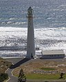 Slangkop Lighthouse, near Kommetjie
 -
 Duiker Island, Hout Bay
 -
 The new Chapmans Peak Drive
 -
 Hout Bay


Other free image and media sources[rediger]
-
English: Pengiuns near Cape Town
-
-
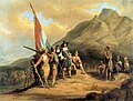
 English: Rhodes memorial.


