Category:16 Lubartowska Street in Lublin
Jump to navigation
Jump to search
| Object location | | View all coordinates using: OpenStreetMap |
|---|
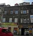
Polski: Lublin, ul. Lubartowska 16 - zespół kamienicy, 1883-1898:
- kamienica, 1883-1898 (ID 606111)
- oficyna boczna, 1883-1898 (ID 720758)
Media in category "16 Lubartowska Street in Lublin"
The following 5 files are in this category, out of 5 total.
-
 Lublin, ul. Lubartowska 16; kamienica z boczną oficyną -widok od W.jpg 3,622 × 2,061; 1.49 MB
-
 Lublin, ul. Lubartowska 16; kamienica, boczna oficyna -widok od ul. Wodopojnej.jpg 3,813 × 2,496; 1.89 MB
-
 PL Lublin Lubartowska 16 kamienica.jpg 2,329 × 2,464; 3.49 MB
-
 PL Lublin Lubartowska 16 kamienica2.jpg 3,264 × 2,448; 4.52 MB
-
 PL Lublin Lubartowska 16 kamienica3.jpg 1,788 × 2,630; 3.18 MB


