Category:1781 maps of New Jersey
Jump to navigation
Jump to search
States of the United States: California · Massachusetts · New Hampshire · New Jersey · New York · Virginia
| 1780 1781 1782 1784 |
Media in category "1781 maps of New Jersey"
The following 19 files are in this category, out of 19 total.
-
 A map containing part of the Provinces of New York and New Jersey, LOC gm71005417.jpg 11,006 × 20,254; 27.97 MB
-
 A map containing part of the Provinces of New York and New Jersey, LOC gm71005417.tif 11,006 × 20,254; 637.77 MB
-
 A map of Monmouth County. LOC gm72003604.jpg 16,217 × 9,048; 14.52 MB
-
 A map of Monmouth County. LOC gm72003604.tif 16,217 × 9,048; 419.8 MB
-
 A map of part of the province of Jersey. LOC gm72003589.jpg 8,264 × 6,151; 6.3 MB
-
 A map of part of the province of Jersey. LOC gm72003589.tif 8,264 × 6,151; 145.43 MB
-
 A map, Middlesex County. LOC gm72003603.jpg 8,665 × 7,694; 6.65 MB
-
 A map, Middlesex County. LOC gm72003603.tif 8,665 × 7,694; 190.74 MB
-
 A map, Somerset County. LOC gm72003602.jpg 8,172 × 5,829; 5.48 MB
-
 A map, Somerset County. LOC gm72003602.tif 8,172 × 5,829; 136.28 MB
-

-

-
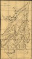
 A sketch of the northern parts of New Jersey. LOC gm72003605.jpg 10,324 × 11,900; 16.35 MB
-
 A sketch of the northern parts of New Jersey. LOC gm72003605.tif 10,324 × 11,900; 351.49 MB
-
 Carte de la Pensylvanie et du Nouveau Jersey (NYPL b15346084-433617).jpg 4,479 × 2,633; 2.25 MB
-

-

-
 Position du camp de l'armée combinée a Philipsburg du 6 juillet au 19 aoust. LOC gm71000986.jpg 12,676 × 5,216; 6.97 MB
-
 Position du camp de l'armée combinée a Philipsburg du 6 juillet au 19 aoust. LOC gm71000986.tif 12,676 × 5,216; 189.17 MB


.jpg)
.jpg)