Category:1850s railroad maps of the United States
Jump to navigation
Jump to search
Subcategories
This category has the following 2 subcategories, out of 2 total.
Media in category "1850s railroad maps of the United States"
The following 23 files are in this category, out of 23 total.
-
 1850 Galena & Chicago Union.jpg 1,134 × 788; 156 KB
-
 1850 IC.jpg 3,536 × 5,856; 2.99 MB
-
 1850 Michigan Southern.jpg 6,678 × 2,700; 2.12 MB
-
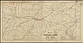
 1850 Ohio & Pennsylvania.jpg 12,256 × 4,736; 5.49 MB
-
 1850 Western District of Columbia.jpg 852 × 1,513; 365 KB
-
-
-
 1850s PW&B map.jpg 8,138 × 2,480; 6.79 MB
-
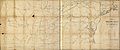 1851 PRR.jpg 17,184 × 7,168; 18.48 MB
-

-

-
 1852 Map of the Virginia Central Railroad and Planned Construction.jpg 8,425 × 5,747; 7.08 MB
-

-
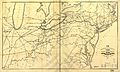 1853 Erie.jpg 14,176 × 8,448; 18.4 MB
-
 1855 Erie.jpg 10,656 × 5,375; 9.17 MB
-
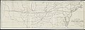
 1855 PRR.jpg 21,344 × 2,656; 11.73 MB
-
 1856 Chesterfield RR.jpg 1,094 × 574; 210 KB
-
 Wytheville Mt Airy Map 1856.JPG 659 × 432; 76 KB
-
 Map of the Milwaukee and Mississippi Rail-Road (13995291355).jpg 2,000 × 751; 1.51 MB
-
 1857 PRR.jpg 2,592 × 1,306; 977 KB
-
 185x Portland & Ogdensburg.jpg 7,942 × 5,917; 6.66 MB
-
 Rail road and county map of Illinois showing its internal improvements 1854. LOC 98688464.jpg 8,464 × 10,784; 18.87 MB
-
 Rail road and county map of Illinois showing its internal improvements 1854. LOC 98688464.tif 8,464 × 10,784; 261.14 MB


.jpg)