Category:1875 maps of Oklahoma
Jump to navigation
Jump to search
States of the United States: California · Connecticut · Illinois · Indiana · Iowa · Massachusetts · Michigan · New Jersey · New York · Ohio · Oklahoma · Oregon · Pennsylvania · Tennessee · Texas · Utah · Virginia · Wyoming
| 1875 1876 1879 |
Media in category "1875 maps of Oklahoma"
This category contains only the following file.
-
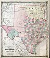 Warner & Beers County Map of Texas and Indian Territory 1875 UTA.jpg 4,661 × 5,368; 11.21 MB
