Category:1888 maps of Washington, D.C.
Jump to navigation
Jump to search
States of the United States: California · Connecticut · Florida · Georgia · Idaho · Illinois · Indiana · Iowa · Kansas · Massachusetts · Michigan · Minnesota · Missouri · Montana · New Hampshire · New York · North Carolina · North Dakota · Ohio · Oregon · Pennsylvania · South Carolina · South Dakota · Tennessee · Texas · Virginia · Washington · Wisconsin · Wyoming – Washington, D.C.
| ← 1880 1884 1885 1888 → |
Subcategories
This category has only the following subcategory.
Media in category "1888 maps of Washington, D.C."
The following 22 files are in this category, out of 22 total.
-
 "The Rest" - (part of Tenleytown, Washington D.C.) LOC 88693134.jpg 3,719 × 5,160; 2.54 MB
-
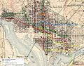 1888 WDC Streetcar Map.JPG 1,042 × 816; 326 KB
-

-

-

-
 Map of the city of Washington showing the location of sewers - October 1st 1888 LOC 87695545.jpg 8,521 × 8,864; 10.64 MB
-
 Map of the city of Washington showing the location of sewers - October 1st 1888 LOC 87695545.tif 8,521 × 8,864; 216.09 MB
-

-

-
 Map of Washington, D.C. - NARA - 31491082.jpg 9,813 × 9,909; 10.92 MB
-

-

-

-

-

-

-
 Plat of survey and subdivision of "Washington Heights" LOC 79694113.jpg 6,326 × 8,044; 4.63 MB
-
 Plat of survey and subdivision of "Washington Heights" LOC 79694113.tif 6,326 × 8,044; 145.59 MB
-
 Plat of survey and subdivision of "Washington Heights" LOC 79694114.jpg 6,632 × 8,311; 4.88 MB
-
 Plat of survey and subdivision of "Washington Heights" LOC 79694114.tif 6,632 × 8,311; 157.7 MB
-
 Sanborn Fire Insurance Map from Washington, District of Columbia, District of Columbia. 1888 Page 1.tif 13,662 × 9,900; 386.99 MB
-

_LOC_88693134.jpg)


